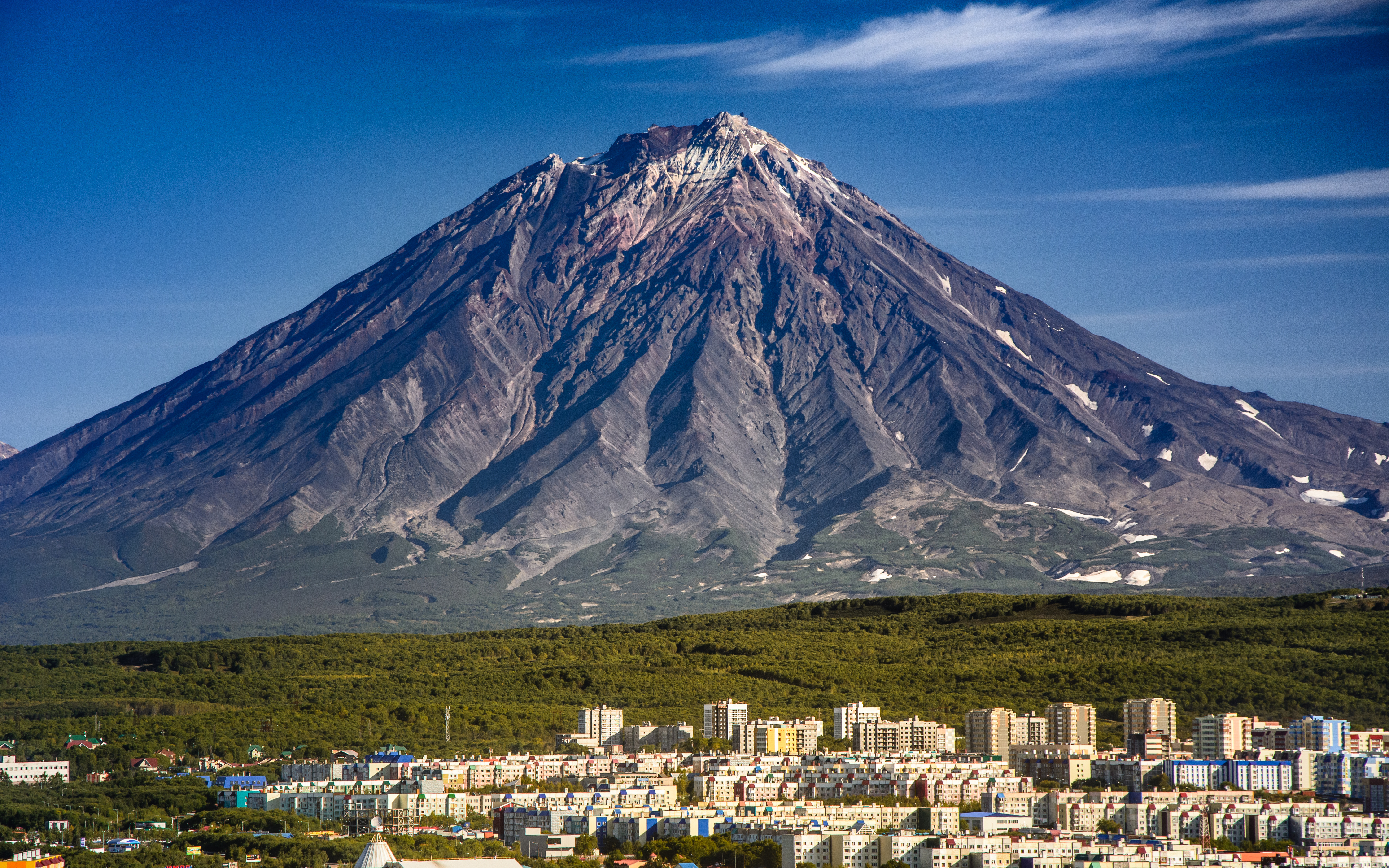
Kamchatka
Petropavlovsk-Kamchatsky is the second-largest mainland city in the world that cannot be reached by road. The largest is Iquitos, deep in the Peruvian Amazon. That comparison hints at Kamchatka's fundamental character: a 1,250-kilometer peninsula jutting into the North Pacific, larger than the state of California, home to 160 volcanoes and roughly 315,000 people -- half of whom live in and around the capital. There are no highways leading in, no railroad, no bridge. You fly, or you do not come at all. The isolation has preserved something extraordinary: a landscape where fire, ice, and wildlife coexist on a scale that most of the planet lost centuries ago.
Where Fire Meets Ice
Kamchatka sits where the Pacific Plate dives beneath the Okhotsk Plate, and the geological consequences are spectacular. Twenty-nine of its 160 volcanoes are active. Nineteen of them collectively form a UNESCO World Heritage Site. The Kronotsky Nature Reserve, accessible only by helicopter, contains the Valley of the Geysers -- until a catastrophic mudslide buried two-thirds of it in 2007, this was the second-largest geyser field on Earth and the only one in all of Eurasia, with 90 geysers steaming in a six-kilometer valley. Two of the most powerful earthquakes ever recorded struck the peninsula: a 9.3-magnitude event in 1737 and a 9.0 in 1952, the latter generating a tsunami that damaged Hawaii and reached Chile and New Zealand.
Bering's Gateway
In 1740, Vitus Bering sailed into Avacha Bay and founded a settlement named after his two ships, the St. Peter and the St. Paul -- Petropavlovsk. One year later, survivors of Bering's second expedition staggered back to that settlement carrying news of his death, the discovery of Alaska, and bundles of sea otter pelts so luxurious they sparked Russia's expansion across the Pacific. The city endured a legendary siege during the Crimean War in 1854, when roughly 920 Russian defenders held off a joint Anglo-French fleet of 6 ships with approximately 200 guns and 1,700 troops. After that, Russia razed and abandoned the city rather than risk another attack. Kamchatka faded from strategic importance until World War II, when the Soviet military declared the entire peninsula a closed zone -- off-limits to Russian civilians until 1989 and to foreigners until 1991.
Bears, Salmon, and Acid Lakes
Brown bears wander into the suburbs of Petropavlovsk-Kamchatsky with enough regularity that locals treat it as routine rather than crisis. In the backcountry, bears are the dominant presence: the peninsula's rivers run thick with chinook, sockeye, coho, and pink salmon, and the bears know every fishing spot. Kamchatka contains the southernmost expanse of Arctic tundra on Earth, and its wildlife reflects that position at the edge of the subarctic. Giant Kamchatka crabs fill the waters offshore, selling locally at a fraction of their international price. The volcanic terrain produces features found almost nowhere else: lakes of concentrated acid, hot springs that steam through snow, and geothermal vents that keep patches of ground warm enough to walk on barefoot in winter.
Cold War Shadow
Kamchatka's remoteness made it ideal for purposes its indigenous Itelmen and Koryak peoples never imagined. The peninsula hosts Russia's largest nuclear submarine pen and construction yard. The Kura Missile Test Range in the north serves as the impact zone for intercontinental ballistic missiles fired from launch sites thousands of kilometers away. In 1983, Soviet forces shot down Korean Air Flight 007, a civilian airliner that strayed over Kamchatka's restricted military airspace -- all 269 people aboard were killed. Until 1994, the United States maintained Eareckson Air Station on Shemya Island, just 935 kilometers from Kura, equipped with the Cobra Dane radar to monitor Soviet missile tests. The military presence that closed Kamchatka for decades also, inadvertently, protected its wilderness from development.
Getting There Is the Adventure
All commercial flights land at Yelizovo, 16 kilometers from Petropavlovsk-Kamchatsky. From there, reaching the peninsula's wonders requires helicopter charters in aging Mi-8 workhorses, six-wheel-drive trucks on unpaved tracks, or, in the village of Esso, dogsleds used in place of taxis. Weather cancellations are routine -- one traveler reported spending 13 days on the peninsula before managing a helicopter excursion on day 12. Indigenous Itelmen villages can be visited five hours from the capital, and at summer's end, the Alhalalalai festival celebrates Itelmen culture with traditional dance and ceremony. For those willing to endure the logistics, Kamchatka offers volcano climbing, heli-skiing, bear watching, salmon fishing, and the deep quiet of a landscape that has simply never been tamed.
From the Air
Located at 57.00N, 160.00E, the Kamchatka Peninsula extends roughly 1,250 km from north to south in the Russian Far East. The sole commercial airport is Yelizovo (UHPP), 16 km from Petropavlovsk-Kamchatsky. The peninsula is defined by two parallel volcanic mountain ranges with a central valley. Klyuchevskaya Sopka (4,750 m) is the highest active volcano in Eurasia and a prominent landmark. Approach from the east over the Pacific for dramatic volcano views. Watch for volcanic ash advisories -- eruptions frequently disrupt trans-Pacific air routes. Expect marine weather, frequent cloud cover, and strong winds.