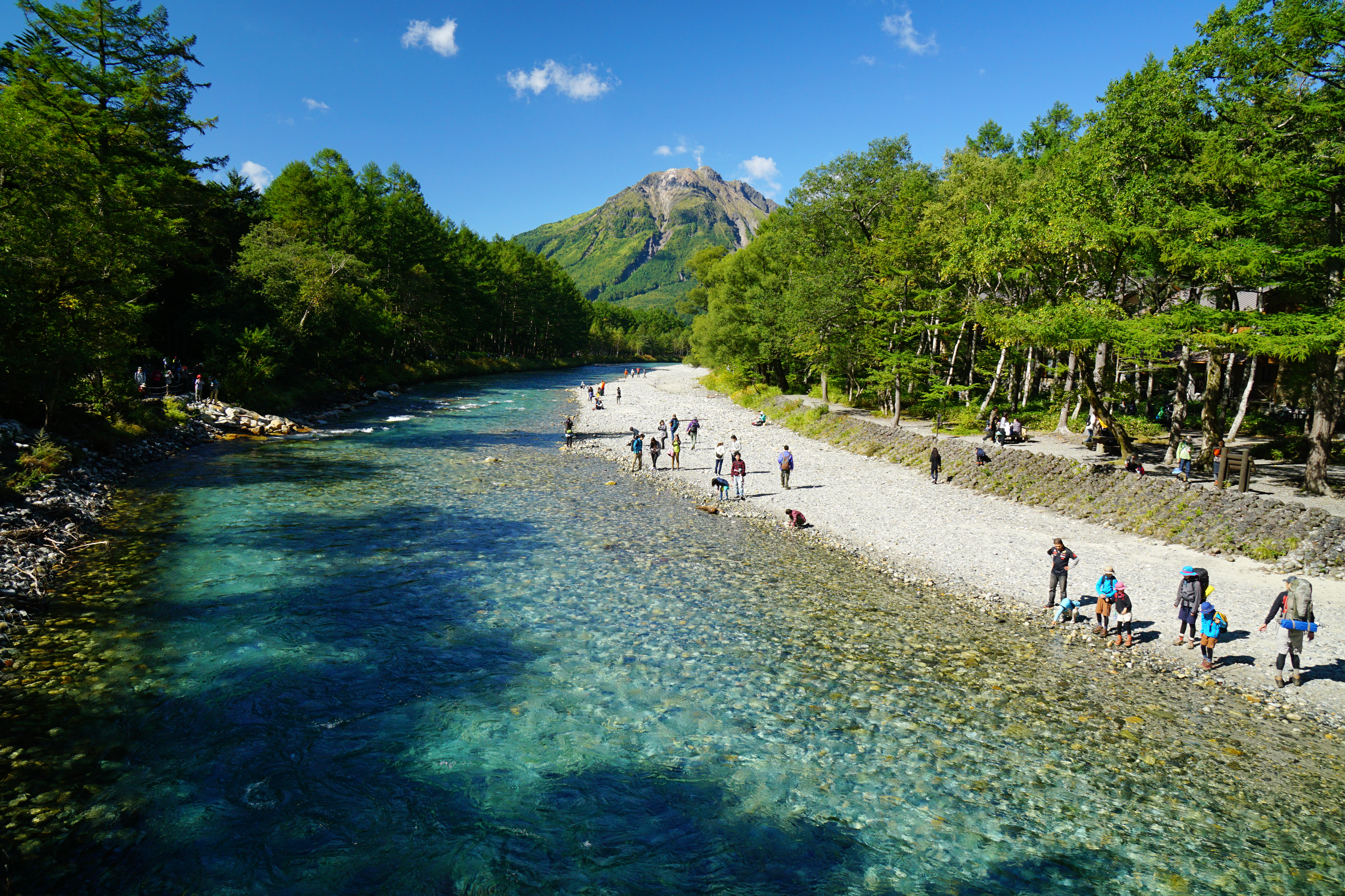
Kamikochi
A narrow suspension bridge sways over water so clear you can count the stones on the riverbed. This is Kappa-bashi, named for the mythical water creatures said to lurk in Japan's mountain streams, and it is the gateway to one of the most carefully protected alpine valleys in Asia. Kamikochi sits between 1,400 and 1,600 meters above sea level in the heart of the Hida Mountains, an 18-kilometer corridor of marshes, ponds, and old-growth forest flanked by some of Japan's tallest peaks. No private cars have been allowed past the Kama Tunnel since 1994. The only way in is by shuttle bus or taxi, a deliberate inconvenience that has kept this valley startlingly wild.
Where Volcanoes Built a Lake
The valley owes much of its character to Mount Yake, the active volcano that anchors its southern end. In 1915, during the Taisho period, Yake erupted and dammed the Azusa River, creating Lake Taisho -- a shallow, luminous body of water where the skeletal trunks of drowned trees still stand like bleached sentinels. The Azusa River itself is the headwater of the Shinano, Japan's longest river, and it threads the entire length of the valley before spilling into that volcanic lake. Because the valley floor is remarkably flat for such mountainous terrain, marshes and ponds appear everywhere: Takezawa Marsh, Tashiro Pond, Myojin Pond. Fed by snowmelt and underground aquifers, the water stays cold enough to sting even at the height of summer.
The Missionary and the Mountain Fever
Until the mid-nineteenth century, Kamikochi was a logging site, its old-growth timber systematically felled and floated down the Azusa. The valley's transformation from resource extraction zone to conservation icon began with an unlikely figure: Reverend Walter Weston, a British Anglican missionary who arrived in Japan in 1888. Weston fell in love with the Northern Alps and climbed extensively through the region, later publishing his experiences in a book that introduced recreational mountaineering to a Japanese audience. His advocacy helped build the case for designating Kamikochi as a protected area. Every June, the Weston Festival at Kamikochi marks the opening of the climbing season with a ceremony at his bronze memorial plaque. The Japanese Alpine Club, which Weston helped establish in 1905 as its first honorary member, continues to steward the mountaineering tradition he championed.
Kappa on the Bridge
The valley's most famous landmark carries a name from folklore. Kappa-bashi, the narrow pedestrian bridge over the Azusa River, references the kappa -- mischievous water deities from Japanese mythology believed to inhabit mountain streams. The literary connection deepened in 1927 when novelist Ryunosuke Akutagawa published Kappa, a satirical novel that helped spark a domestic tourism boom to the area. The bridge's naming actually predates the novel, though its exact origin remains uncertain. Today, Kappa-bashi is the first thing most visitors encounter after stepping off the shuttle bus. From the bridge, Mount Hotaka fills the northern horizon, its jagged ridgeline often veiled in clouds. The park facilities -- camping areas, traditional ryokan inns, a post office, souvenir shops -- cluster between the bus terminal and this crossing, making the bridge both a literal and symbolic threshold between civilization and wilderness.
The Cathedral of Peaks
Kamikochi is ringed by an extraordinary assembly of summits. Mount Hotaka to the north includes Oku-Hotaka-dake, the highest point in the Hida Mountains at 3,190 meters and the third-tallest peak in all of Japan. Mount Yari, the spear-shaped peak nicknamed the Matterhorn of Japan, stands at 3,180 meters to the northeast. Mount Yake smolders to the south. The valley serves as basecamp for multi-day traverses linking these giants, with the Yarigatake route and the Yari-Hotaka ridge walk ranking among the most celebrated alpine hikes in the country. Mountain huts dot the higher elevations, making overnight expeditions surprisingly accessible. The park opens mid-April and closes mid-November, with peak crowds arriving during summer school holidays and again in October when the autumn foliage sets the valley ablaze in amber and crimson.
A Valley Held in Trust
Kamikochi holds dual designation as both a Special Natural Monument and a Special Place of Scenic Beauty -- distinctions reserved for Japan's most exceptional landscapes. The entire valley falls within Chubu-Sangaku National Park, and the restrictions are strict: no private vehicles, no permanent residential development, limited commercial activity. The Tokusawa area at the valley's far northern end once served as grazing land for horses and cattle, but even that was absorbed into the park in 1934. Japanese macaques forage along the riverbanks. Bear bells hang at trailheads. The commitment to preservation means Kamikochi today looks much as it did when Weston first walked its trails, a rare thing in a nation where development presses hard against every wild place.
From the Air
Kamikochi valley sits at 36.247N, 137.633E, at 1,400-1,600 meters elevation in the Hida Mountains (Northern Alps). The valley runs roughly north-south for 18 km, flanked by peaks exceeding 3,000 meters including Mount Hotaka (3,190 m) to the north and active volcano Mount Yake to the south. Lake Taisho is visible at the southern end. The nearest airport is Matsumoto Airport (RJAF), approximately 50 km east. Approach with caution -- surrounding terrain rises steeply to over 3,000 meters, and mountain weather can deteriorate rapidly. The valley floor itself is identifiable by its flat, marshy terrain contrasting sharply with the surrounding steep ridgelines.