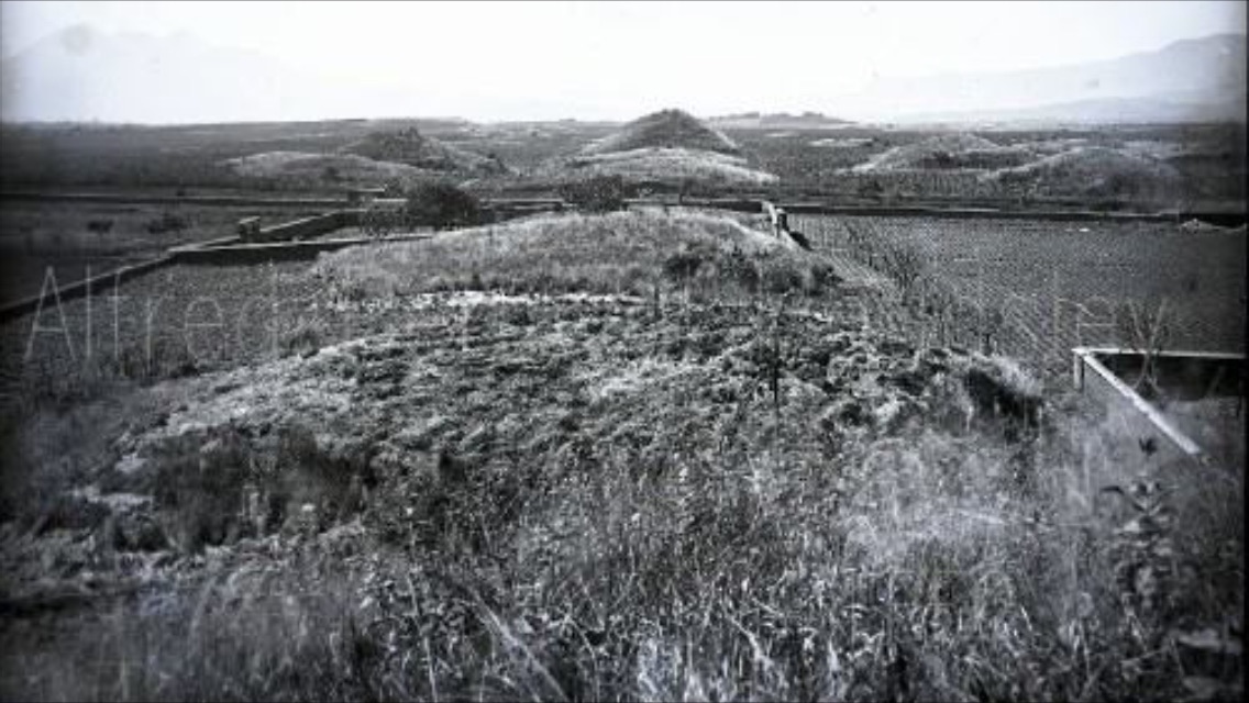
Kaminaljuyu
Somewhere beneath the parking lots and apartment blocks of Guatemala City's Zone 7, a civilization produced fifteen million pottery fragments in a single mound. That number — estimated by archaeologists who excavated Kaminaljuyu, the "Hill of the Dead" in the K'iche' language — hints at the industrial scale of a city most people drive over without knowing it exists. Occupied from roughly 1500 BC to 1200 AD, Kaminaljuyu once comprised some 200 platforms and pyramidal mounds spread across five square kilometers of highland valley. At its peak, between 400 BC and 100 AD, it was among the largest and most influential urban centers in the Maya world. Today, a half-square-kilometer park preserves a fraction of what remains — fewer than 35 mounds out of the original hundreds, the rest consumed by the sprawl of a modern capital that grew directly on top of its ancient predecessor.
A City Built on Ash
Kaminaljuyu's setting was both its advantage and its defining constraint. The valley floor sits on volcanic deposits hundreds of meters deep — rich soils ideal for farming but devoid of the limestone that Maya builders in the lowlands used for their monumental architecture. Without suitable stone, Kaminaljuyu's people built their pyramids and temples from adobe, layering structures one atop another in what archaeologists describe as an onion-skin fashion. The largest excavated mound, designated E-III-3, contained seven buildings nested inside each other across centuries of construction. Within it lay two extraordinarily rich royal tombs, probably belonging to consecutive rulers during the Miraflores period — the city's golden age. The surrounding landscape was shaped by deep volcanic ravines called barrancos, and at the city's heart lay Lake Miraflores, a shallow body of water that sustained early settlement before eventually drying up.
Obsidian and Empire
What Kaminaljuyu lacked in building stone, it more than compensated for in trade. The El Chayal obsidian quarry, roughly 25 miles to the east, supplied volcanic glass that Kaminaljuyu's workshops shaped into tools and exported across the Maya realm. Large-scale obsidian workshops dotted the ancient city, and the material became a source of both wealth and political leverage. By the Middle Preclassic period, the community was large enough to generate heavy refuse deposits — the archaeological signature of dense, permanent habitation. Cotton, maize, avocados, cacao, black beans, and sapodilla all grew in the rich volcanic soil. Specialists practiced loom-weaving and expert pottery-making. Arboriculture flourished, with groves of crop trees terraced down to the edges of the great ravines. Kaminaljuyu was not merely a ceremonial center. It was a working city — a place where people farmed, manufactured, traded, and governed on a scale that predated the better-known Classic Maya cities of the Peten lowlands by centuries.
Before the Lowlands Rose
For decades, scholarly attention focused on the great Classic Maya cities of the northern lowlands — Tikal, Calakmul, Palenque — and Kaminaljuyu faded into the background of Maya studies. But the site's significance is hard to overstate. Large-scale stone carvings found here were forerunners of Classic Maya carving, and Kaminaljuyu appears to have had a literate elite before anywhere else in the Maya world. Uncarved stelae — upright stone shafts associated with time-reckoning and kingship — appeared at Kaminaljuyu and nearby sites during the Middle Preclassic, marking the emergence of institutions that would define Maya civilization for the next millennium. Religious practices elaborated here during this period included the erection of mounds as substructures for temples, the development of a complex pantheon of deities rooted in mythology of which the Popol Vuh preserves a fragment, and warfare to procure captives for royal sacrifice. The Southern Maya Area, long overshadowed, is now understood as seminal to the civilization's origins.
Swallowed by Its Successor
Kaminaljuyu's destruction was not dramatic. No invading army burned it. No volcanic eruption buried it in ash. Instead, Guatemala City simply grew over it, one subdivision at a time. When archaeologists first mapped the site in the 1930s, roughly 200 mounds were still visible. A local football club discovered one of the most important buried structures by accident, cutting into the edge of an inconspicuous mound to lengthen their practice field. The Carnegie Institution of Washington sent Alfred Kidder, Jesse Jennings, and Edwin Shook to investigate, and their resulting monograph brought the first sustained scholarly attention to the site. But excavation could not keep pace with development. By the late twentieth century, the vast majority of the ancient city had been built over — its adobe pyramids bulldozed or simply absorbed into the foundations of modern buildings. The archaeological park that remains is a small green island in a sea of concrete, preserving enough to suggest the scale of what was lost but not enough to convey it.
From the Air
Kaminaljuyu's archaeological park is located at 14.635°N, 90.542°W in Zone 7 of Guatemala City, roughly 3 km west of the city center. From 3,000-5,000 feet AGL, the park appears as a small green rectangle amid dense urban development in the western suburbs. La Aurora International Airport (MGGT) lies approximately 5 km to the southeast. Guatemala City sits at roughly 4,900 feet elevation in a highland valley. The volcanic peaks of Agua, Fuego, and Acatenango are visible to the west and southwest on clear days. The deep barrancos (ravines) that once defined the ancient city's geography are still visible as green corridors cutting through the urban grid.