Kangra Valley Railway
The metal ball is warm from the last driver's hand. At each station along the Kangra Valley Railway, the locomotive pilot receives a token -- a steel sphere released from a Neale's Ball Token instrument -- that grants sole authority to enter the next stretch of single-line track. No electronic override, no satellite link. Just a ball on a ring, passed from stationmaster to driver, exactly as it has been done since the 1930s. This 164-kilometer narrow-gauge line from Pathankot in Punjab to Jogindernagar in Himachal Pradesh is the longest narrow-gauge railway in India, and it runs on a signaling system so old it has become heritage in its own right.
A Railway Born Twice
The idea for the line emerged from competing ambitions. Surveys in 1912 and 1914 envisioned opening the Kangra and Kullu valleys for their timber and mineral wealth, but the colonial government judged the returns too slim. What changed the calculus was hydropower: the proposed Uhl Hydropower Project at Shanan required heavy equipment that only rail could deliver. The railway appeared in the 1926-1927 budget, and on May 2, 1926, William Malcolm Hailey, Governor of Punjab Province, broke ground. Captain E.B.N. Taylor of the North Western State Railway supervised construction. The Pathankot-to-Nagrota section opened for freight on December 1, 1928, and the full line to Jogindernagar followed on April 1, 1929, when passenger service began. The original cost estimate of 113 lakh rupees ballooned to 296 lakh -- more than double -- thanks to the terrain that made the railway so spectacular and so expensive to build.
Dismantled for War, Rebuilt for Peace
In 1942, the British Empire needed steel more than it needed a mountain railway. Track and iron infrastructure from Nagrota to Jogindernagar were ripped up and shipped to the Middle East for the war effort, truncating the line to just 67 miles. Twelve years passed before restoration came. On April 15, 1954, with Lal Bahadur Shastri serving as India's Railway Minister, the full Kangra Valley Railway reopened -- an act of reconstruction that carried symbolic weight for a newly independent nation reclaiming its infrastructure. The line faced another disruption in 1973 when the Maharana Pratap Sagar reservoir submerged part of the original route. Engineers diverted the track to higher ground along the reservoir's eastern shore, abandoning the stations at Anur and Mangwal. The new alignment opened on December 29, 1976, giving the railway its current path.
993 Bridges and a Sharpest Curve
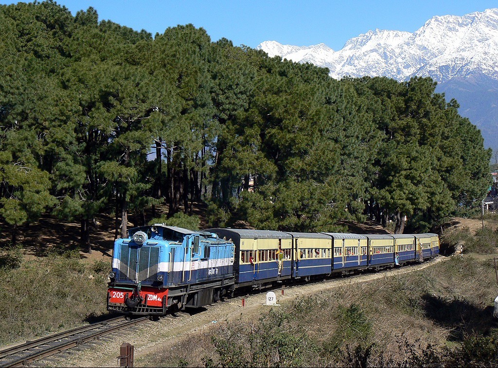
The statistics read like a dare. In its 164 kilometers, the Kangra Valley Railway crosses 993 bridges, navigates 484 curves, passes through two tunnels -- Dhundi and Daulatpur -- and climbs from the plains of Pathankot at 384 meters above sea level to its highest point at Ahju station, 1,290 meters up. The sharpest turn is Curve Number 300. The steepest gradient, 1 in 25, comes just beyond Baijnath Paprola station, where the line drops toward a 13th-century Shiva temple visible from the platform. Between Guler and Palampur, the Dhauladhar mountains reveal themselves in stages: first as distant white ridges, then as an overwhelming wall of snow and rock that never quite leaves your peripheral vision. The Reond Gorge, spanned by a steel arch bridge near Kangra station, offers a view straight down into the chasm carved by the Baner Khad river.
Tea Gardens to Terminus
The final section from Palampur to Jogindernagar is the most dramatic. Leaving Palampur, the line passes through tea gardens that have made the town famous, then begins its steepest climbing. At Panchrukhi, a chalet-style station building evokes the colonial era when British engineers dotted the route with alpine-inspired architecture. Ahju station, the line's summit, has a similar charm -- a small building perched at 1,290 meters with the unhurried atmosphere of a place that time has treated gently. From Ahju, the railway descends through low hills, crosses the Gugli Khad, and winds into Jogindernagar, where two platforms and a rolling-stock inspection pit mark the end of the line. The Kangra Valley Railway sits on India's tentative list for UNESCO World Heritage status, recognized not for any single monument but for the entirety of the experience: the bridges, the tunnels, the ball-token signals, the slow revelation of the Himalayas through a train window.
From the Air
The railway runs roughly east-southeast from Pathankot (32.27N, 75.65E) to Jogindernagar (31.99N, 76.79E) across 164 km of Himalayan foothills in Himachal Pradesh. The line is visible from moderate altitude as a thin thread following river valleys below the Dhauladhar range. Key landmarks include the Maharana Pratap Sagar reservoir near the western section and the Kangra Fort near Kangra station. Nearest airports: Pathankot Airport (VIPK) at the western terminus and Gaggal Airport (VIGG) near Kangra. The snow-capped Dhauladhar peaks to the north provide excellent visual reference. Best visibility in autumn and winter months when haze is minimal.