Kaniakapupu
The name means "the singing of the land shells." Kaniakapupu, deep in the forested upper slopes of Nu'uanu Valley on Oahu, was named for the kahuli -- tiny tree snails that Hawaiian folklore says could vocalize and sing sweet songs after dark. The snails are nearly gone now, victims of invasive predators, and the palace they serenaded is a ruin swallowed by bamboo. But in the 1840s, this was the summer retreat of King Kamehameha III and Queen Kalama, a stone house five miles outside Honolulu where the Hawaiian monarch escaped the dust and heat of his capital. In 1847, an estimated ten thousand guests gathered here for a grand luau celebrating Hawaiian Sovereignty Restoration Day. By 1874, maps labeled it "Old Ruins." No one recorded why it was abandoned.
A King's Escape
In the early nineteenth century, Honolulu was a dusty, arid settlement. The only reliable water came from the Nu'uanu Stream, and the summer heat drove anyone who could afford it a few miles upvalley into the forested highlands, where the air was cool and the vegetation thick. American missionaries, white merchants, and Hawaiian royals all built European-style homes in this green suburb. Kamehameha III chose the land division called Luakaha -- "place of relaxation" -- about five miles from town, reachable by horse and carriage. Governor Kekuanao'a oversaw the construction of a stone house there, noted in the journal of missionary Amos Starr Cooke on July 5, 1842. By 1845, the retreat was complete, timed to coincide with the capital's move from Lahaina to Honolulu. The king modeled his new arrangement of residences -- the official Hale Ali'i in town and the country house in Nu'uanu -- on the spatial layout of Moku'ula, his former royal complex in Lahaina.
The Feast of Ten Thousand
The palace's most famous moment came on July 31, 1847, when Kamehameha III hosted a massive luau to celebrate the restoration of Hawaiian sovereignty after a brief British occupation in 1843. Contemporary accounts describe an estimated ten thousand guests -- chiefs, commoners, foreign dignitaries, and missionaries -- feasting among the trees. Children from the Royal School attended with their teachers, the Cookes; among those children were all of the future Hawaiian monarchs. Danish explorer Steen Anderson Bille, who visited Oahu in 1846 during his circumnavigation aboard the corvette Galathea, described the retreat as a place of genuine hospitality. New England merchant Gorham Gilman, who lived in the islands from 1840 to 1861, left another written account. These scattered descriptions are all that survive of a place that was, for a few years, the social heart of the Hawaiian kingdom.
Layers Beneath the Stones
The site carries history older than the palace. Oral traditions associate the area with a heiau -- a Hawaiian temple -- dedicated to Lono, the god of fertility and healing. Archaeologists Susan Lebo and James Bayman, writing in 2001, note that the name Kaniakapupu may be a modern misnomer originating in the early twentieth century. The actual Kaniakapupu Heiau, also called Kawaluna Heiau, was associated with Kuali'i, a sixteenth-century high chief who consolidated control over the Kona district of Oahu after a ceremony there. Tradition holds that Kamehameha I rested his troops near Luakaha during his 1795 invasion of Oahu, the campaign that culminated in the Battle of Nu'uanu, where defeated warriors were driven off the Nu'uanu Pali to their deaths. The palace, then, sits on ground layered with conquest, ceremony, and power -- centuries of Hawaiian history compressed into a few acres of forest.
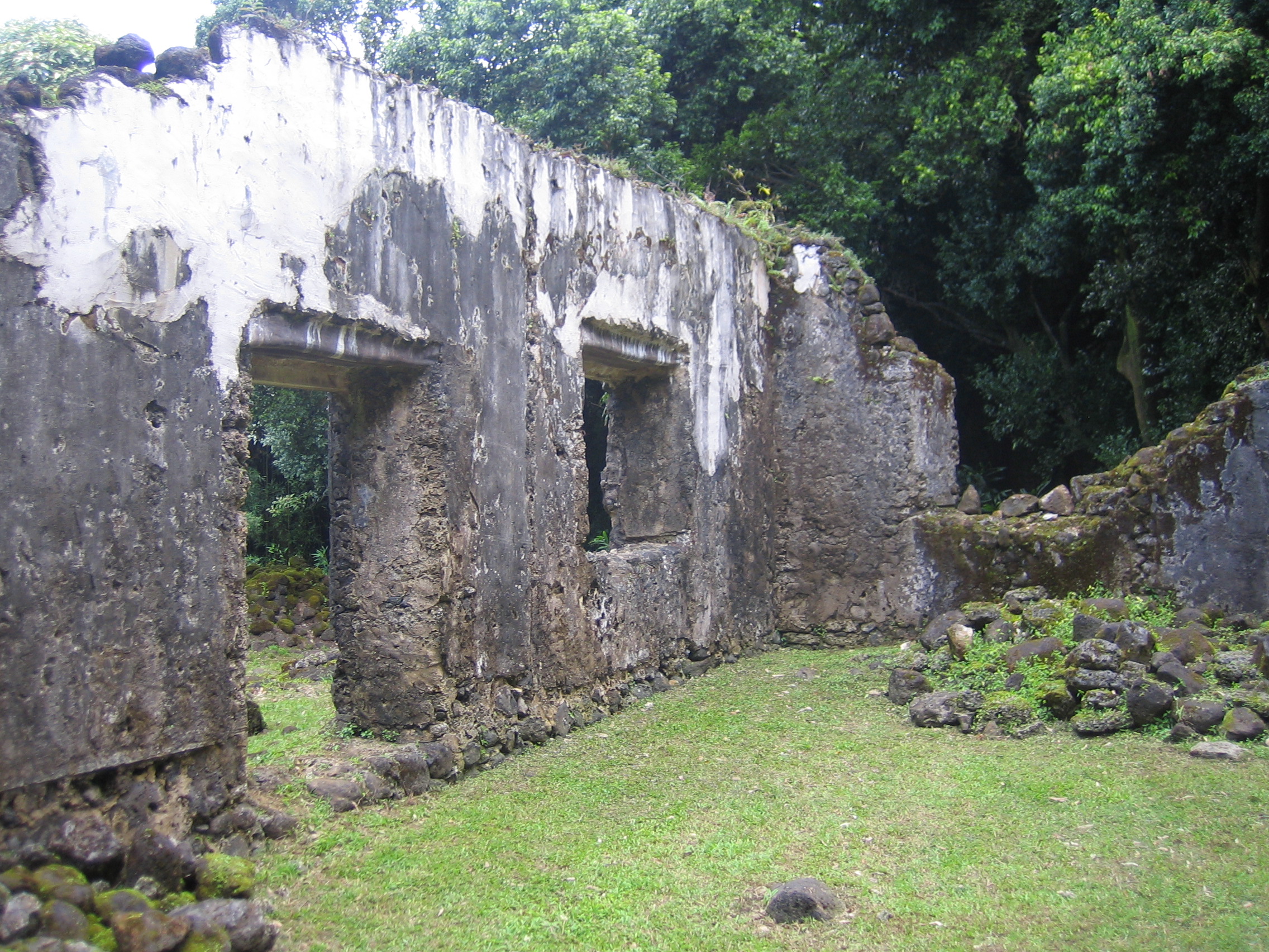
Ruins and Reckoning
Rediscovered in the 1950s, the ruins were cleared and stabilized by the Territorial Commission on Historic Sites. But neglect returned, and by the 1980s the forest had reclaimed much of the structure. The Historic Hawaii Foundation established a preservation fund in 1998, and conservation work was completed two years later. Kaniakapupu was added to the National Register of Historic Places in 1966. Today the site is managed by the State Historic Preservation Division, with help from the volunteer organization Aha Hui Malama O Kaniakapupu. It remains officially off-limits to the public -- accessible only by an unmarked trail off the Pali Highway through dense invasive bamboo -- though enforcement is sporadic. In 2016, vandals scratched crosses into the historic stone walls. Social media had drawn visitors who treated the ruins as a photo backdrop rather than a sacred place. The state responded by asking websites and tourism blogs to remove directions to the site. The singing snails are silent. The stones, slowly, are learning to be forgotten again.
From the Air
Located at 21.35N, 157.81W in the upper Nu'uanu Valley on Oahu, beneath the Ko'olau Range. The ruins are hidden beneath dense canopy and not visible from the air, but the valley itself -- a deep green corridor running north from Honolulu toward the Pali -- is distinctive. Best context at 2,000-4,000 feet AGL approaching from the south. The Nu'uanu Pali lookout is visible at the head of the valley. Nearest airports: PHNL (Honolulu International, 6 nm SW), PHNG (Kaneohe Bay MCAS, 4 nm NE).