Kaptai Dam
Bangladesh has exactly one hydroelectric power station. That fact alone makes Kaptai Dam significant -- a single earth-fill embankment on the Karnaphuli River, upstream from Chittagong in the Rangamati District, generating every watt of hydroelectric power the country produces. But the dam's significance extends well beyond its turbines. When the reservoir filled in the early 1960s, it drowned the farmland and homes of the Chakma people, an indigenous community that had lived in the Chittagong Hill Tracts for generations. More than 40,000 Chakma fled to India. They were never compensated. The scarcity of land that followed is considered a root cause of armed conflict that has simmered in the Hill Tracts ever since.
Sixty Years of Planning
Engineers first contemplated damming the Karnaphuli in 1906, during the British colonial period. A second study followed in 1923, but nothing came of either. After partition, the idea gained urgency: East Pakistan needed power, and the Karnaphuli's flow through the steep hills north of Chittagong offered genuine potential. In 1946, E. A. Moore recommended a dam site at Barkal, 65 kilometers upstream of where the dam would eventually be built. Four years later, the Marz Rendal Vatten Consulting Engineers proposed Chilardak, 45 kilometers upstream. Government engineers countered with Chitmoram, downstream. It was not until 1951, under chief engineer Khwaja Azimuddin, that the final site at Kaptai was selected. The American firm Utah International Inc. won the construction contract, and work began in 1957.
Concrete, Corruption, and Cold War Cash
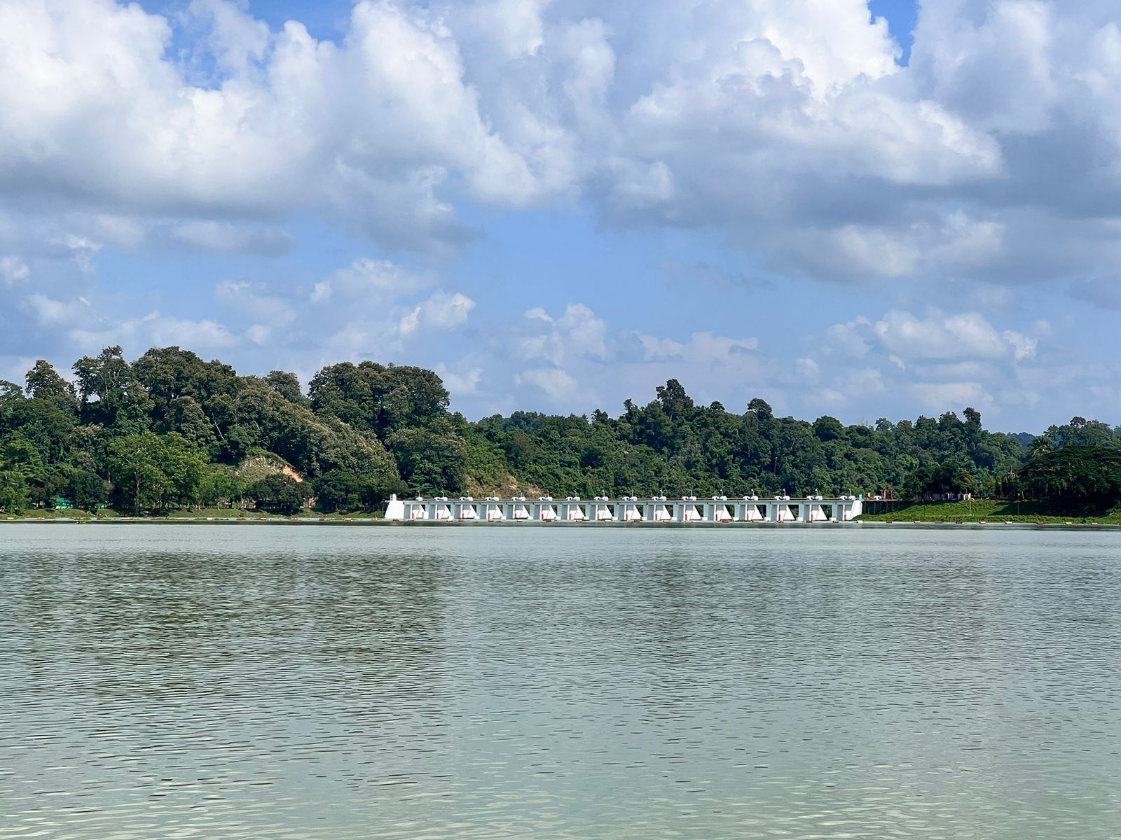
The dam was a Cold War project as much as an engineering one. Financed jointly by the East Pakistan government, the United States, and the Overseas Economic Cooperation Fund, it carried a price tag of $100 million -- enormous for the era and the region. American aid to Pakistan was notoriously plagued by mismanagement, and the Karnaphuli project was no exception. Progress stalled until Governor Azam Khan partnered with American aid chief Colonel Charles W. Edwards to push the project through. The Chicago Daily News reported that the dam's completion in 1962, during the presidency of Ayub Khan, represented the first major success of American aid in the region. The initial build included a spillway, penstock, and two 40 MW Kaplan turbine generators. A third 50 MW generator followed in 1982, and two more in 1988, bringing total capacity to 230 MW.
The People the Reservoir Swallowed
When Kaptai Lake began to fill behind the new dam, it swallowed farms, villages, and a way of life. The Chakma people -- an indigenous Buddhist community with deep roots in the Chittagong Hill Tracts -- lost their homes and the fertile valley land they had cultivated for generations. No compensation was offered. More than 40,000 Chakma crossed the border into Arunachal Pradesh, India, where their descendants still live, many without citizenship rights more than sixty years later. Those who remained found themselves crowded onto shrinking tracts of hillside land, competing for resources with Bengali settlers who migrated into the area. The resulting tensions escalated into armed insurgency, and the Chittagong Hill Tracts became one of South Asia's longest-running low-intensity conflicts.
Power and Its Price
From the air, Kaptai Lake is striking: a long, sinuous reservoir winding through green hills, its fingers reaching into narrow valleys. It looks like wilderness. It is, in part, a graveyard of villages. The dam itself -- an earth-fill embankment, unremarkable by engineering standards -- sits where the river narrows before beginning its final descent toward Chittagong and the Bay of Bengal. The Karnafuli Hydroelectric Power Station beside it hums along, feeding electricity into a national grid that serves 170 million people. Bangladesh has since built gas-fired and coal-fired power plants, but Kaptai remains the country's only source of hydroelectric energy, a distinction that makes it both indispensable and irreplaceable. The wilderness that once surrounded the river has not recovered. The wildlife habitats that the reservoir destroyed are gone, and the ecological cost continues to compound alongside the human one.
From the Air
Located at 22.50N, 92.23E in the Chittagong Hill Tracts. Kaptai Lake is the dominant visual feature -- a large, irregularly shaped reservoir clearly visible from cruising altitude, snaking through green hill terrain. The dam itself sits at the southern end of the lake where the Karnaphuli River narrows. Shah Amanat International Airport (VGEG) in Chittagong is approximately 60 km to the southwest. Approach from the west for the best view of the full reservoir extent. The area is hilly with elevations reaching 500-1,000 ft, so maintain adequate altitude.