Karafuto Prefecture
For thirty-eight years, the southern half of Sakhalin Island was Japanese. Maps labeled it Karafuto, and its capital, Toyohara -- now Yuzhno-Sakhalinsk -- had paved streets, paper mills, Shinto shrines, and a railway station built in the style of a Japanese country town. When the Soviet army crossed the 50th parallel in August 1945, three days before Japan's surrender, it swept away a colonial world so thoroughly that today you have to look carefully to find any trace of it at all.
Spoils of an Earlier War
Karafuto became Japanese territory in 1905, after the Russo-Japanese War ended with the Treaty of Portsmouth. Russia ceded the portion of Sakhalin south of the 50th parallel, and Japan established a formal prefecture in 1907 to govern its new northern frontier. The first capital was Otomari -- the town the Russians had called Korsakov -- before the administration moved to Toyohara in 1908. Initially classified as part of Japan's external lands, Karafuto was incorporated into the Japanese metropole in April 1943, a bureaucratic elevation that reflected both the territory's growing population and the empire's wartime need to consolidate its holdings. By that point, over 400,000 people lived there.
Paper, Coal, and Northern Frontier Life
Karafuto's economy ran on resources pulled from the land and the sea. Fishing and forestry dominated, supplemented by coal and petroleum extraction. The paper industry was particularly well developed -- the island's vast conifer forests fed pulp mills that supplied rayon production across the empire. Agriculture struggled against the short growing season, but the Japanese settlers adapted, and towns like Esutoru in the north central region and Maoka on the west coast grew into functioning communities with schools, hospitals, and rail connections. The railway network, built to Japanese narrow gauge, linked the major settlements and carried timber and coal to the ports. Some of those locomotive frames would later serve the Soviet Railways until 1979, relics of one empire put to work by another.
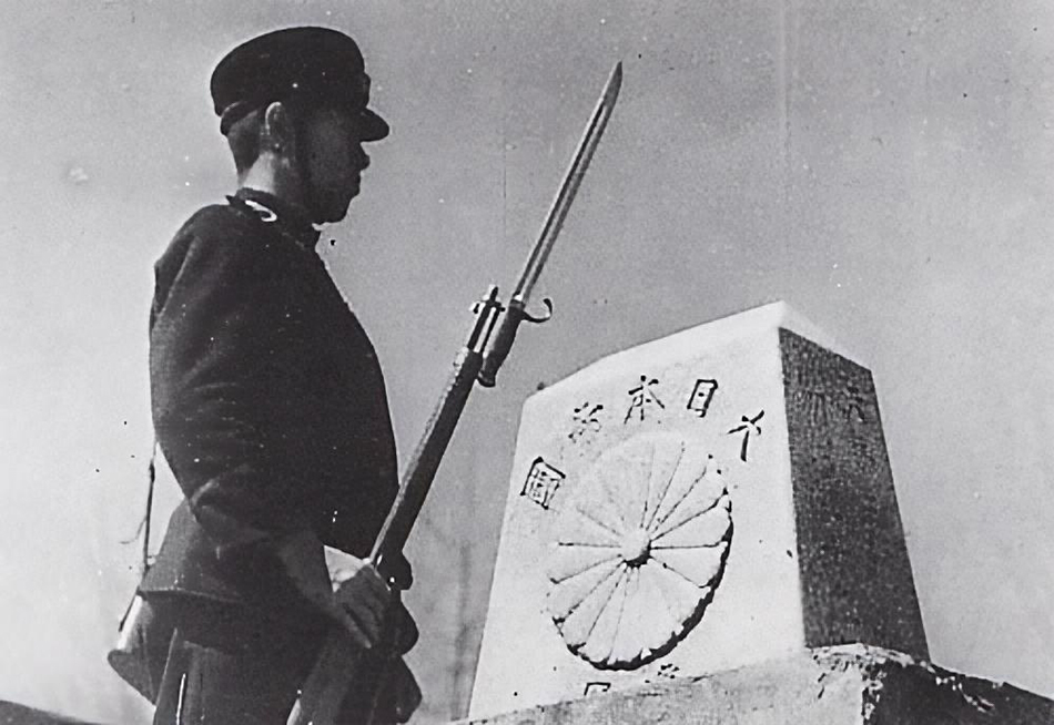
Eleven Days in August
The Soviet invasion of Karafuto began on August 11, 1945, when the 56th Rifle Corps crossed the 50th parallel. Japan's border fortifications were no match for the assault. The fighting was fierce but brief, and it came with a human cost that statistics alone cannot convey. Of the more than 400,000 civilians -- Japanese, Korean, a small White Russian community, and indigenous Ainu -- roughly 100,000 managed to flee south to Hokkaido before the Soviet forces sealed the escape routes. The rest were stranded. The military government established by the Soviet Army banned emigration, trapping hundreds of thousands of people in a territory that had been their home under one flag and was now claimed by another.
The People Left Behind
Repatriation came slowly, unevenly, and not for everyone. Most ethnic Japanese were eventually permitted to return to Japan, but the process stretched over years and left deep scars. Ethnic Koreans, many of whom had been brought to Karafuto as laborers during the colonial period, faced a different fate -- caught between a Japan that did not want them and a Soviet Union that had no plan for them, many remained on Sakhalin for decades. The indigenous Ainu, whose presence on the island predated both empires by millennia, were displaced yet again. The prefecture that Japan had governed for nearly four decades dissolved into memory, its towns renamed in Russian, its shrines dismantled, its paper mills converted or abandoned.
Traces in the Landscape
Flying over southern Sakhalin today, the grid patterns of Japanese-era town planning are still faintly visible beneath the Soviet and post-Soviet development. In Yuzhno-Sakhalinsk, the former Toyohara, a Japanese-built museum survives as the Sakhalin Regional Museum, its pagoda-style architecture an incongruous reminder of the colonial period. The railway gauge has long since been converted to Russian broad gauge, but the routes follow the paths Japanese engineers surveyed a century ago. Karafuto is gone from the maps, but not entirely from the ground. The island remembers, even when the signs are in a different language.
From the Air
Located at 48.50N, 142.50E in southern Sakhalin Island. The former Karafuto Prefecture covered everything south of 50N on Sakhalin. Toyohara (now Yuzhno-Sakhalinsk) is the former capital, visible as the largest city in southern Sakhalin. The 50th parallel, the former border, crosses the island's narrow waist. Nearest airport: Yuzhno-Sakhalinsk (UHSS). The railway corridor and town grids of the former Japanese prefecture are visible from altitude.