Karakum Desert
Somewhere in the Karakum Desert, a hole in the earth has been on fire for more than fifty years. Soviet geologists accidentally punched into a natural gas pocket near the town of Darvaza in 1971. The drilling rig collapsed into the cavern, and someone decided to set the escaping gas alight rather than let it poison the surrounding area. The fire was supposed to burn out in weeks. It never did. The Darvaza gas crater, which locals call the Door to Hell, still glows at night, a ring of flame visible from the surrounding darkness of a desert that covers roughly 350,000 square kilometers.
Black Sand Nation
The name Karakum translates to "Black Sand," a reference to the dark, shale-rich sediment beneath the surface. This desert occupies about seventy percent of Turkmenistan, stretching in a long east-west swath from near the Caspian Sea to the border with Uzbekistan, where it meets the Kyzylkum, the "Red Sand" desert. Together, they form the fourth-largest desert system in the world. The population density tells the story of habitability: one person per 6.5 square kilometers. The desert divides into three distinct regions. The elevated Trans-Unguz Karakum occupies the north. The low-lying Central Karakum spreads through the middle. The southeastern Karakum, home to a chain of salt marshes, trails off toward the Afghan border.
Rivers That Vanish
Water has always been the Karakum's defining contradiction. The Murghab and Tejen rivers flow north out of the Hindu Kush mountains, enter the desert from the south, and simply disappear, absorbed by sand and irrigation before reaching any sea. The Amu Darya skirts the desert's northeastern edge, its waters now largely diverted into the Karakum Canal, the second-largest irrigation canal in the world. This canal carries water hundreds of kilometers south across the desert, sustaining the cotton fields that Soviet planners built and that independent Turkmenistan continues to cultivate. The cost of this engineering has been measured in the disappearance of the Aral Sea to the north, where the diversion of its feeder rivers has created the Aralkum, a new desert occupying fifteen thousand square miles of former seabed since the early 1980s.
Life in the Furnace
Despite its harshness, the Karakum supports a community of adapted species. Corsac foxes hunt at night. Goitered gazelles move across the hardpan in small herds. Tolai hares and jerboas emerge from burrows after sunset. Lizards, turtles, and snakes dominate the reptile fauna, while the insect world includes ants, termites, dung beetles, and darkling beetles. Desert sparrows and larks are among the few birds that maintain year-round populations. The landscape looks barren from above, but at ground level, every dune system and salt flat hosts its own miniature ecosystem shaped by millennia of adaptation to extremes of heat, cold, and drought.
Ancient Rivers, Future Lakes
The Karakum carries geological memories of a wetter past. During the late Pleistocene, the Amu Darya flowed not to the Aral Sea but westward through the desert to Sarykamysh Lake and then to the Caspian Sea. Sedimentation and floods redirected the river, eventually carving the connection to the Aral Basin. Now Turkmenistan is attempting to reverse the desert's aridity by force. A man-made lake is under construction in the Karashor Depression, planned to span 770 square miles with a maximum depth of 230 feet when complete. Filling it could take fifteen years and cost up to 4.5 billion dollars. A network of collector canals totaling 2,650 kilometers will carry irrigation runoff to the site. Whether this lake becomes a thriving reservoir or a saline evaporation basin remains an open question.
The Door to Hell
The Darvaza gas crater remains the Karakum's most famous landmark. Roughly seventy meters across, the crater burns continuously, its flames fed by the same vast natural gas reserves that make Turkmenistan one of the world's major gas-producing nations. Hundreds of visitors travel to the remote site each year, camping at the crater's edge to watch the fire illuminate the desert night. The area also sits above significant oil deposits. Together, oil and gas extraction and cotton irrigation define the Karakum's modern economy, two industries that draw wealth from beneath and across a landscape that most of the world imagines as empty.
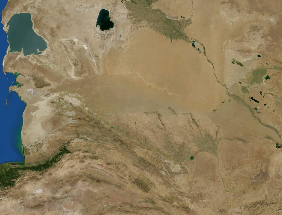
From the Air
Centered approximately at 39.00N, 60.00E, the Karakum Desert covers most of Turkmenistan. From cruising altitude, the landscape is an immense expanse of tan, gray, and brown terrain with minimal vegetation. The Karakum Canal is visible as a thin dark line cutting south across the desert. The Darvaza gas crater, at approximately 40.25N 58.44E, is identifiable at night by its glow. Key airports include Ashgabat (UTAA), Mary (UTAM), and Turkmenbashi (UTAK). The Caspian Sea coastline defines the western boundary. Best visibility in cooler months; summer heat creates significant haze and turbulence at lower altitudes.