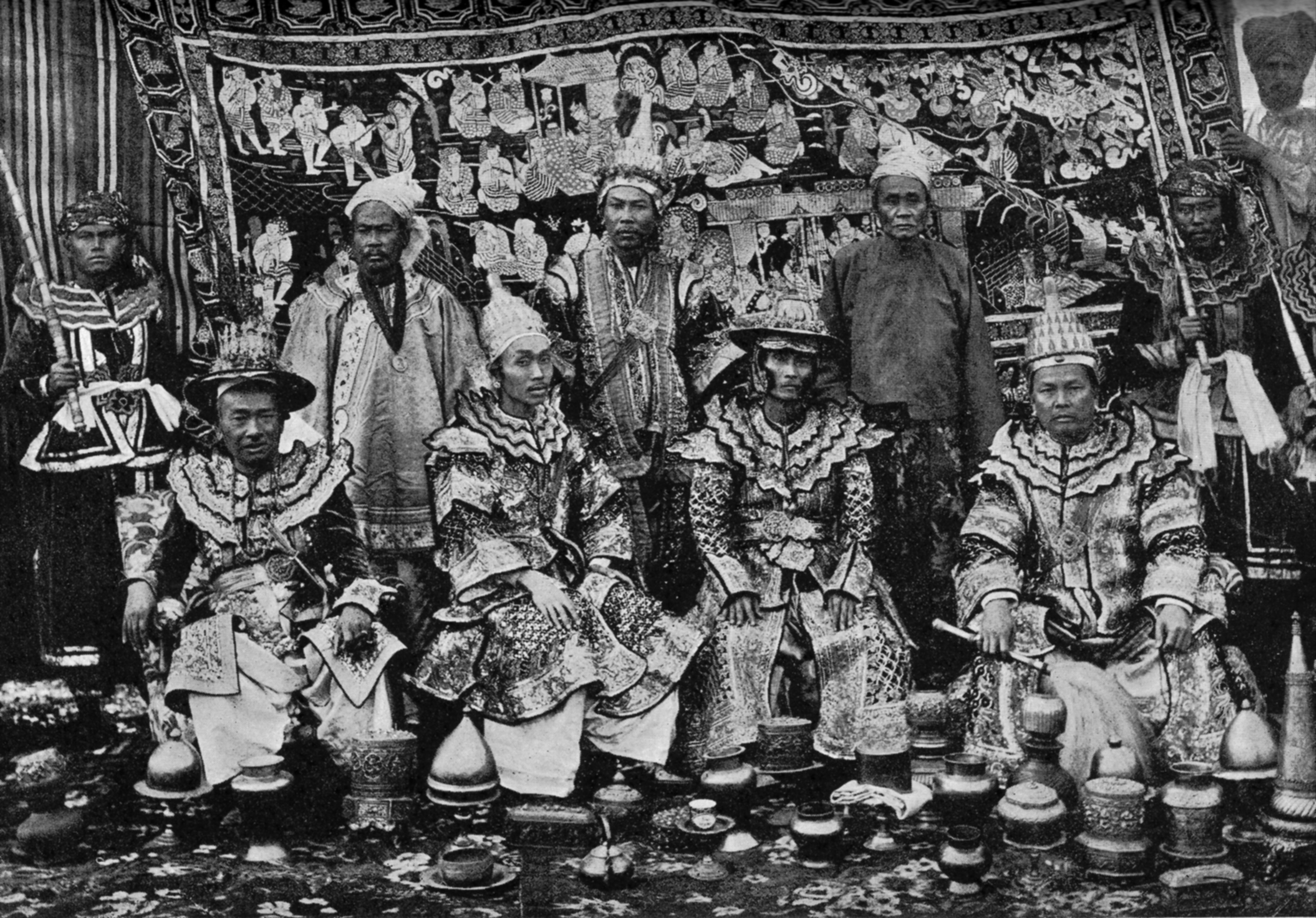
Karenni States
In 1875, the British Empire and Burmese King Mindon Min signed a treaty that recognized something unusual: a set of small highland states that belonged to neither of them. The Karenni States, home to the Red Karen people in what is now eastern Myanmar's Kayah State, occupied a legal limbo that would persist for decades. That ambiguity defined them. Too small to be independent, too remote to be easily governed, and too proud to be absorbed without a fight, the Karenni have spent more than a century navigating between empires, colonial powers, military juntas, and their own fierce desire for self-determination.
Five Principalities on the Salween
Historical records for the Karenni States before the nineteenth century are sparse. Local tradition holds that a principality led by a ruler called a Sawphya existed under Shan overlordship, gradually gaining independence during the eighteenth century. By the 1800s, the territory had split into five principalities: Kyebogyi, the largest of the western states at 350 square miles; Bawlake at 200 square miles; tiny Naungpale and Nammekon; and Kantarawadi, the eastern state spanning 2,500 square miles across both sides of the Salween River. In 1901, the total population across all five states was fewer than 46,000 people. What they lacked in numbers, however, the Karenni compensated for in strategic geography, sitting astride the routes between the Shan highlands, the Sittang valley, and the Thai border.
Neither Burma's Nor Britain's
The Karenni's ambiguous status began with a plea for protection. In 1864, a Karenni prince asked the British for protectorate status, fearing Burmese encroachment. The British declined. When the prince died in 1869, his two sons tried again. The British refused once more, but they did agree to arbitrate with the Burmese king. When Burma insisted on its claims over Karenni territory, Britain responded not by absorbing the states but by recognizing four of them as independent under British protection on June 21, 1875. Kantarawadi, the largest state, was left independent without even that tenuous shield. This arrangement created a political oddity: states that were technically sovereign yet dependent on a colonial power that had not formally colonized them. In 1892, the Karenni rulers accepted stipends from the British government, making their states tributary to British Burma, and an assistant superintendent stationed at Loikaw exercised day-to-day oversight. By the 1930s, the Mawchi Mine in Bawlake had become one of the world's most important sources of tungsten, giving the small states an outsized economic significance.
War and Partition
World War II brought another power into the Karenni highlands. In May 1942, the Thai Phayap Army invaded neighboring Kengtung State, and by December, under an agreement between Thai Prime Minister Plaek Phibunsongkhram and the Empire of Japan, Thailand had annexed Kengtung and parts of the surrounding territory. Eastern Kantarawadi, more than half its total area, fell under Thai administration as part of the newly declared Saharat Thai Doem province, formalized in August 1943. After the war, the 1947 Constitution of the Union of Burma amalgamated the Karenni States into a single unit called Karenni State, with a provision allowing secession after ten years. In 1952, the Burmese government added the former Shan state of Mong Pai and renamed the whole Kayah State, a move widely seen as an attempt to divide the Karenni from the broader Karen independence movement in neighboring Karen State.
A People Displaced
The division did not produce the obedience the Burmese government sought. The Karenni fought alongside other Karen peoples against successive military governments, and by the 1980s the Karen National Liberation Army counted some 20,000 members. The political wing, the Karen National Union, pursued both armed resistance and diplomacy, gaining admission to the Unrepresented Nations and Peoples Organization in 1993. But for the Karenni people themselves, decades of conflict brought consequences measured in human lives rather than political milestones. Burmese military presence in Kayah State grew around hydropower installations and mining operations, and with it came land confiscation, forced labor, sexual violence, and landscapes seeded with landmines. By 2004, the BBC estimated that up to 200,000 Karen, including Karenni, had been displaced by the fighting, while another 160,000 lived in refugee camps on the Thai side of the border. The largest camp, at Mae La in Thailand's Tak province, housed around 50,000 people.
The Fight That Never Ended
In February 2010, reports documented the Burmese army burning Karen villages and displacing thousands more. Accusations of ethnic cleansing came from Karen leaders and the U.S. State Department alike. The Karen National Union relocated its headquarters to Mu Aye Pu, on the Myanmar-Thailand border, a position that spoke to both the movement's resilience and its displacement. For the Karenni, the irony of their history is the persistence of the condition that defined them in 1875: they remain a people whose sovereignty has been acknowledged in principle and denied in practice. The five small principalities on the Salween are gone, their rulers' powers formally surrendered to the Burmese government on April 29, 1959. But the question the Karenni have been asking since a prince first petitioned the British in 1864 -- who has the right to govern us? -- remains unanswered.
From the Air
The historical Karenni States correspond to modern Kayah State in eastern Myanmar, centered around 18.50N, 98.00E. The terrain is mountainous highlands bisected by the Salween River, with the Thai border to the east. Loikaw, the administrative center, sits in a river valley surrounded by hills. Nearest airports: Loikaw Airport (VYLO) and Heho Airport (VYHE) approximately 100 nm northwest. The rugged topography is best appreciated at 10,000-15,000 feet AGL, where the contrast between the river valleys and surrounding highlands is dramatic.