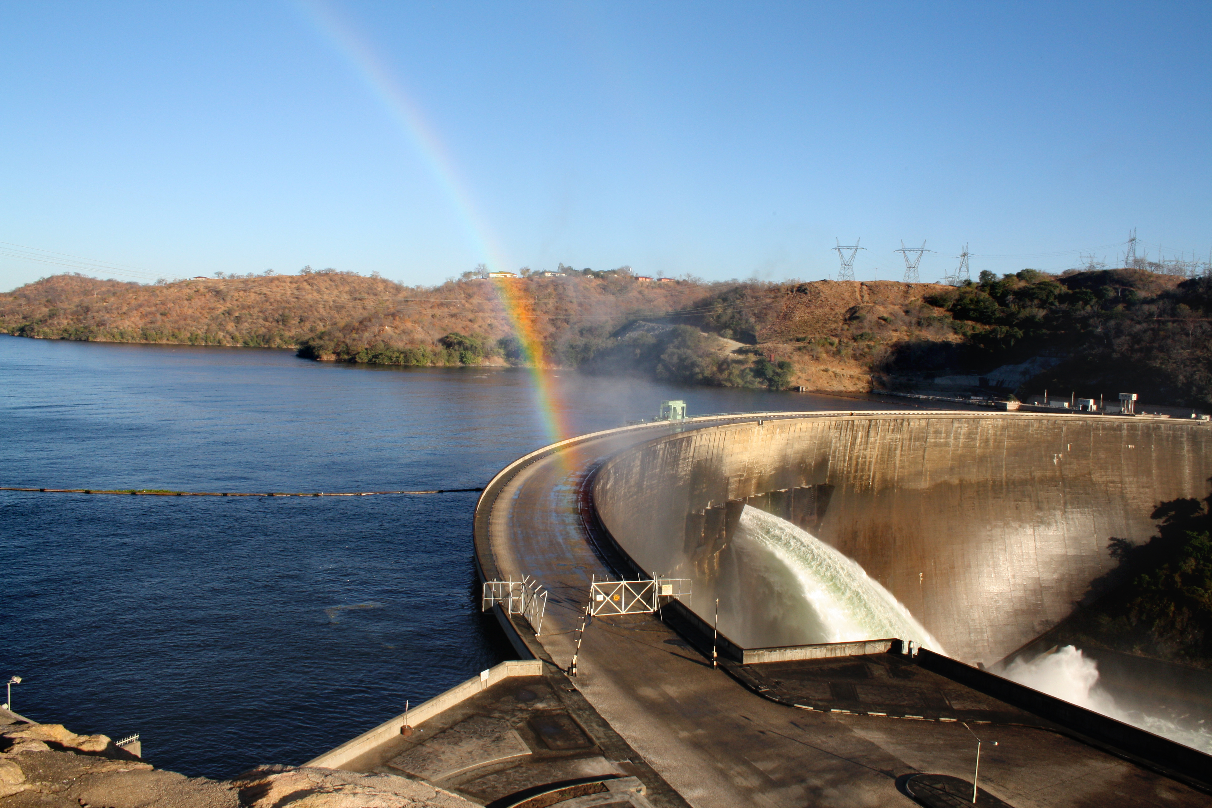
Kariba Dam
Eighty-six men died building it. Their names are not recorded in most accounts of Kariba Dam, but the concrete arch they raised between 1955 and 1959 still holds back the Zambezi River in a gorge between Zambia and Zimbabwe. Standing 128 meters tall and 579 meters long, the dam created Lake Kariba -- a reservoir stretching 280 kilometers and holding 185 cubic kilometers of water, making it the largest man-made lake in the world by volume when it filled. Queen Elizabeth the Queen Mother opened the dam on 17 May 1960. What she inaugurated was not just a power station but a fulcrum of southern African geopolitics, ecology, and human displacement whose consequences are still unfolding.
A River Divided by Politics
Before the dam existed, there was a simpler plan. Northern Rhodesia wanted to build a smaller dam on the Kafue River, closer to the Copperbelt mines that needed electricity. It would have been cheaper, less disruptive, and adequate for the region's needs. Southern Rhodesia, the wealthier partner in the Federation of Rhodesia and Nyasaland, overruled the idea and insisted on Kariba -- grander, more expensive, and positioned on its own doorstep. The Italian firm Cogefar-Impresit won the construction contract. By the time political problems delayed completion of the full project until 1977, costs had ballooned to $480 million. Today the dam is jointly owned by Zimbabwe and Zambia through the Zambezi River Authority, each country operating its own power station on opposite banks. Zimbabwe's south station, expanded in 2018 with Chinese-financed turbines, generates 1,050 megawatts. Zambia's north station, expanded in 2013, produces 960 megawatts. Together they supply 2,010 megawatts -- power that both nations depend on and that drought regularly threatens to shut off.
The Tonga Who Lost Their River
When the reservoir began to fill, approximately 57,000 Tonga people living along both banks of the Zambezi were forced from their homes. The resettlement remains one of the worst dam-displacement disasters in African history. Anthropologist Thayer Scudder, who studied the affected communities from the late 1950s onward, documented how promises of support went largely unfulfilled. American writer Jacques Leslie, visiting decades later for his book Deep Water, found conditions little changed since the 1970s. In 2002, displaced communities formed the Basilwizi Trust to advocate for their own development, seeking to serve as a bridge between the people of the Zambezi Valley and their government's decision-making process. Meanwhile, between 1958 and 1961, Operation Noah rescued approximately 6,000 large animals stranded by the rising waters -- a wildlife operation that earned international headlines even as the human cost received less attention.
The Dam That Might Break
In 2014, the BBC reported what engineers had been warning about privately: Kariba Dam was in a dangerous state. Decades of torrents from the spillway had eroded the basalt bedrock beneath the dam, carving a vast crater that undercut its foundations. If the dam failed, the Zambezi River Authority estimated, a tsunami-like wall of water would rip through the valley, reach the Mozambique border within eight hours, overwhelm the Cahora Bassa Dam downstream, and knock out 40 percent of southern Africa's hydroelectric capacity. The lives of 3.5 million people would be at risk. Rehabilitation work began in 2017, financed by the European Union, the World Bank, the Swedish government, and the African Development Bank. The project involves excavating the eroded plunge pool and rebuilding the spillway gates, with completion targeted for 2025. Engineers must work behind a temporary cofferdam to reshape the rock under dry conditions -- a delicate operation on a structure that 3.5 million lives depend upon.
Running on Empty
Even as repairs proceed, climate threatens what engineering might save. In January 2016, water levels dropped to 12 percent of capacity, just 1.75 meters above the minimum operating level for hydropower. By January 2023, levels had fallen to 1 percent of capacity, with output limited to 800 megawatts for only part of the day. Drought, compounded by the overuse of water for power generation, has repeatedly brought the reservoir to the edge of shutdown. The Kariba Dam controls 90 percent of the Zambezi's total runoff, meaning its operation reshapes the entire downstream ecology -- floodplains that once supported rich wildlife habitat now depend on decisions made at the dam's spillway gates. Industrial power users have proposed a 250-megawatt floating solar plant on Lake Kariba to reduce dependence on water levels, an acknowledgment that the hydroelectric certainty the dam was built to provide may no longer be certain at all.
From the Air
Kariba Dam sits at 16.52°S, 28.76°E in the Kariba Gorge on the Zambezi River, straddling the Zambia-Zimbabwe border. From 5,000-8,000 feet AGL, the double-curvature concrete arch is visible spanning the gorge, with Lake Kariba stretching 280 km to the west. The dam wall and spillway are prominent landmarks. Kariba Airport (FVKB) is nearby on the Zimbabwean side. The lake's vast expanse dominates the landscape at higher altitudes. Expect clear conditions in the dry season (May-October) and convective activity during the wet season.