Karijini National Park
Somewhere beneath your feet, the rock is older than the moon. The Pilbara craton — the ancient foundation beneath Karijini National Park — is a fragment of Earth's original crust that somehow survived the planetary violence of 3.5 billion years without being swallowed back into the mantle. Other cratons were ground up and recycled by the milling of plate tectonics. This one endured. It became the Hamersley Range, and the range eroded into the gorges that now cut forty metres deep through banded dolomite and shale, their walls striped red and cream and purple by the chemistry of an early Earth where photosynthetic bacteria were still in the business of rusting the oceans and building an atmosphere.
Written in Stone
About 2.5 billion years ago, the region lay under a shallow sea. Iron ores settled onto that seafloor, interlayered with volcanic ash. The atmosphere held almost no oxygen — the iron was being oxidised not by the air but by marine bacteria performing photosynthesis. Only once all the dissolved iron was consumed did those bacteria begin releasing oxygen into the atmosphere, turning Earth blue from space. That moment, around 2.3 billion years ago, is chemically recorded in Karijini's rock layers. The seabed compressed into dolomite and shale, uplifted into the Hamersley Range, then slowly carved by streams into the gorges visible today. In a wetter climate, mountains this old would have eroded entirely. Semi-desert preserved them. What looks like scenery is actually a geologic archive of life's earliest chapters.
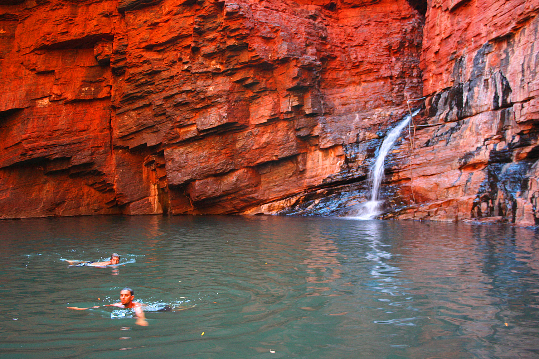
The Gorge Country
The northern edge of the Hamersley Range drops away in a series of gorges where seasonal creeks have cut down through the banded rock over millions of years. Fortescue Falls tumbles into Dales Gorge, where ferns grow incongruously lush in the canyon shadow. Weano Gorge narrows until walkers must wade through its pools, the walls close enough to touch on both sides. Hancock Gorge ends at Kermits Pool, a blue-green basin beneath an overhang of rock polished smooth by ancient floods. The Hamersley Gorge encloses the Spa Pool — water clear enough to read through, ringed by dolomite walls in shades of violet and rust. Each gorge is its own microclimate: sheltered from the desert heat, holding moisture in pockets where the kangaroo paw and mulla mulla bloom through the winter months.
The Human Thread
Aboriginal people have lived in this country for tens of thousands of years, long before the geological name 'Pilbara' was applied to it. The Hamersley Range held water in its gorges even through the driest periods — the rock pools that make the gorges so striking to visitors were survival infrastructure for the people who knew them. Large-scale iron ore mining arrived in the 1960s, when the region's mineral wealth was properly surveyed. The national park was established in 1969 and took its current name in 1991. A freight railway bisects the park today, loaded with iron ore from mines that produce more than any comparable operation on Earth. The two uses coexist uneasily. In 2020, the Juukan Gorge — west of Karijini, containing a cave with evidence of 46,000 years of human habitation — was demolished by Rio Tinto to expand a mine. The act was legal. The outrage that followed was not.
Desert Rules
Summer temperatures in Karijini regularly exceed 40°C. The gorges offer shade and water, which is why hikers descend into them, but those same narrow canyon walls become funnels in flash-flood conditions. Lives have been lost when rain fell kilometres away and the water arrived without warning, filling a gorge in minutes. The rule is absolute: evacuate the gorges immediately when it rains, anywhere in the vicinity. Winter days are warm and clear, the nights dropping toward frost. June through September is when the wildflowers open — the Karijini wattle blooming yellow against red earth — and when the red kangaroos are most easily spotted in the early morning light near the waterholes. Snakes exist but rarely enter the cool gorge floors. The greater hazard is the desert itself: no fuel, no mobile signal in most of the park, no rescue service within easy reach.
Finding the Place
The nearest town with fuel is Tom Price, 80 kilometres west, or Auski to the east. There is no public transport to or within the park. Most of Karijini's gorges are reached by turning off the Great Northern Highway onto Karijini Drive, a good sealed road. The Hamersley Gorge requires a longer detour on Highway 136 to the south. Flying into Tom Price from Perth takes about two hours, and car hire is available there. The Karijini Eco Retreat — the only formal accommodation within the park — runs a restaurant, but capacity is limited and bookings essential. For everything else, bring it with you.
From the Air
Karijini National Park lies at approximately 22.25°S, 117.98°E in the Pilbara region of Western Australia. From altitude, the gorges are not visible — the plateau surface appears as flat reddish desert with subtle tonal banding. The Hamersley Range scarp is visible as a slight elevation change along the northern edge. Nearest airports: Tom Price (YTMP), Newman (YNWN). Approach from the north or east at 4,000 ft or above in VFR conditions — the terrain is benign but remote, with summer turbulence common in the afternoon.