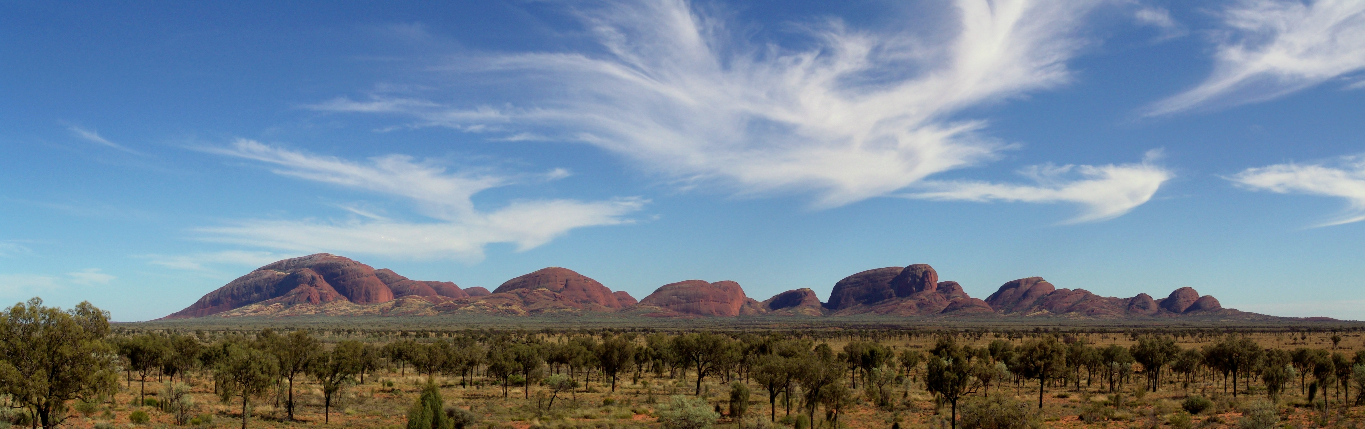
Kata Tjuta
The name means "many heads," and the first glimpse explains why. Thirty-six rounded domes of rust-red conglomerate rise from the flat desert floor southwest of Alice Springs, their shapes suggesting a council of giants frozen mid-conversation. Kata Tjuta -- known to Europeans as The Olgas -- stands 198 meters taller than its famous neighbor Uluru, yet receives a fraction of the attention. For the Anangu people who have lived in this country for tens of thousands of years, the formation is not a tourist attraction but a place of deep spiritual power, home to spirit energy from the Dreaming.
Stone Council of the Amadeus Basin
The domes cover an area of nearly 22 square kilometers, a sprawl of rock that dwarfs most geological formations on Earth. Mount Olga, the tallest dome, reaches 1,066 meters above sea level -- roughly 546 meters above the surrounding plain. From ground level the scale is deceptive; what appears to be a single mass resolves into distinct rounded peaks separated by steep-walled valleys and gorges. The rock itself is conglomerate: cobbles and boulders of granite, basalt, and other types cemented in coarse sandstone. In fresh cross-section it is medium to dark grey, sometimes tinged with green or pink. The vivid orange-red that travelers photograph at sunrise and sunset is a surface patina -- finely divided feldspar coated in iron oxide, a kind of geological rust that gives the entire Red Centre its name.
Six Hundred Million Years of Erosion
To understand Kata Tjuta, you have to think in geologic time. The Amadeus Basin formed roughly 850 to 800 million years ago. During the Petermann Orogeny, about 550 million years ago, tectonic forces pushed ancient granulite rocks northward in an event called the Woodroffe Thrust, and the erosion of those rising mountains deposited the Mount Currie Conglomerate -- the raw material from which both Kata Tjuta and Uluru would eventually be carved. Rubidium-strontium dating places the rock at 600 million years old. What we see today is the remnant of that deposit, sculpted by hundreds of millions of years of wind and water into the domed shapes that now define the landscape. The rock is tough but not eternal; fallen boulders of conglomerate litter the bases of the domes, evidence that the sculpting continues.
A Name Returned
In 1872, explorer Ernest Giles named the tallest dome Mount Olga at the behest of Baron Ferdinand von Mueller, honoring Queen Olga of Wurttemberg. It was a genteel exchange of favors: the queen and her husband, King Charles I, had recently made Mueller a Freiherr, and the naming was his way of repaying the compliment. For over a century the European name stuck. But in 1993 a dual naming policy allowed the Pitjantjatjara name to sit alongside it, and in 2002 the order was reversed: Kata Tjuta now comes first. The shift was more than bureaucratic. It acknowledged what the Anangu had always known -- that these rocks belong to a story far older than any European naming convention.
The Dreaming Lives Here
Much of the mythology surrounding Kata Tjuta is not shared with outsiders. What is known speaks to the depth of its significance: the Anangu believe the domes are homes to spirit energy from the Dreaming, and since 1995 the site has been used once again for cultural ceremonies. Among the stories that have been disclosed, the great snake king Wanambi is said to live on the summit and descend only during the dry season. His breath could transform a gentle breeze into a hurricane to punish wrongdoers. These are not quaint legends but living belief -- the landscape is read as text, every feature carrying meaning accumulated over millennia of continuous habitation.
Walking Between the Heads
Two trails enter the domes. The Valley of the Winds walk covers 7.4 kilometers over three to four hours, threading through gorges between the massive forms where the wind funnels and echoes in ways that justify the name. The shorter Walpa Gorge walk -- 2.6 kilometers, one to two hours -- follows a creek bed between two of the tallest domes into a sheltered valley. Both routes offer sunrise and sunset viewing areas accessible from Kata Tjuta Road. The park sits about 495 kilometers by road from Alice Springs via the Stuart and Lasseter Highways, a drive of roughly four and a half hours through some of the most sparsely populated country on the continent. Arriving at dusk, when the iron oxide patina catches the last light and the domes glow as if lit from within, the name's meaning becomes unmistakable: many heads, turned toward you, waiting.
From the Air
Kata Tjuta is located at 25.30S, 130.76E in the heart of the Red Centre, approximately 25 km west of Uluru. The 36 domes are highly visible from cruising altitude against the flat desert terrain. Connellan Airport (YAYE) at Yulara is the nearest airstrip, about 50 km to the east. Alice Springs Airport (YBAS) lies approximately 365 km to the northeast. Expect excellent visibility in dry conditions; dust storms can reduce visibility significantly. Recommended viewing altitude: 5,000-8,000 ft AGL for the full formation spread.