Katchal Island
At sunrise on January 1, 2000, voyagers from around the world crowded onto Katchal Island to witness what they believed would be the millennium's first sunrise. The moment made international news, and India even issued a commemorative stamp. Less than five years later, on December 26, 2004, the sun rose over a Katchal that barely existed anymore. The tsunami triggered by a magnitude 9.1 earthquake off the coast of Sumatra struck the island with catastrophic force, killing 344 people outright and leaving 1,549 of the roughly 5,000 missing across the Andaman and Nicobar Islands believed to be from Katchal alone. Of the 344 confirmed dead, only one body could be identified.
Ancient Trade Winds
Katchal, known to the indigenous Nicobarese people as Tihnyu, is the largest island in the central group of the Nicobars. Covering 146.5 square kilometers, it sits approximately 1,600 kilometers from the Indian mainland and 305 kilometers south of the territory's capital, Port Blair. Its highest point reaches 227 meters. The Nicobar Islands have drawn outside contact for centuries, positioned as they are along an ancient international sea trade route. An archaeological inscription dating to AD 1059 indicates that the islands were part of the overseas domain of the Tamil Chola king of Tanjore. In 1869, the British acquired the Nicobars from the Danes, folding them into what would become modern India. Languages spoken on Katchal reflect this layered history: Nicobarese, Hindi, Tamil, Telugu, and Santali.
The Protected People
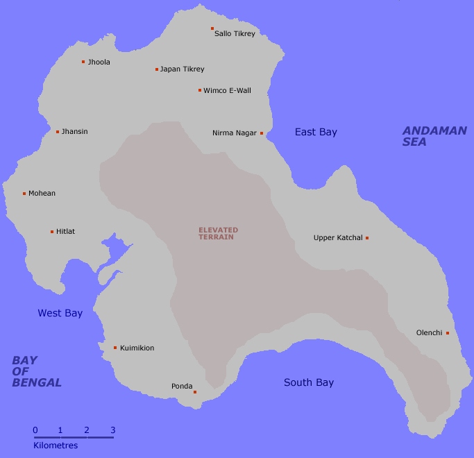
For much of their history, outsiders exploited Katchal's indigenous inhabitants with impunity, taking advantage of the island's remoteness and the islanders' limited contact with the wider world. On April 2, 1957, the Government of India declared the Nicobar Islands an Aboriginal Tribal Reserve Area, restricting access to protect the indigenous population from further exploitation. The designation remains in force. Even Indian nationals require a special tribal pass to visit, and only government servants posted to the island may reside there alongside the Nicobarese. After the 2004 tsunami forced survivors from their scattered villages, the native population regrouped into five tribal settlements: E-Wall, Meenakshi Ram Nagar, Japan Tikrey, Sallo Tikrey, and Upper Katchal. A sixth village, Mildera, houses non-tribal residents, primarily Tamil repatriates and members of the Ranchi community.
When the Wave Came
The scale of the December 26, 2004 tsunami's impact on Katchal is difficult to comprehend. Government staff quarters, built close to the shore, were annihilated. Not a single one of the 47 teachers posted to the island before that day was found alive. Some residents survived by climbing coconut trees and clinging to the tops as the water surged beneath them. The tsunami did not just kill people; it reshaped the island's physical and economic geography. An estimated 112 hectares of agricultural land was rendered useless by saltwater intrusion. Approximately 354,000 coconut trees and an equal number of betel nut trees, the twin pillars of the island's economy, were destroyed. The socioeconomic fabric of a community that had sustained itself for generations was torn apart in minutes.
Life at the Edge of the Map
Katchal is not a place visitors stumble upon. The island is closed to tourists, and special permission from the administration in Port Blair is required for any civilian access. Nine kilometers of paved road connect the settlements, powered by diesel generators. Communication depends on wireless local loop phones, satellite-linked VSAT connections, and spotty mobile service. A single jetty at Nirma Nagar provides the island's connection to the outside world by sea. Despite its isolation, Katchal supports a rich avian population. White-breasted sea eagles patrol the coastline, emerald doves flash green through the forest canopy, and long-tailed parakeets chatter in the coconut groves. The islanders who remain have rebuilt around coconut, betel nut, and areca nut cultivation, supplemented by rubber and red oil palm plantations established in 1968.
Between Sunrise and Aftermath
Katchal's two moments of global attention could not be more different. The millennium sunrise was a celebration, a manufactured event that placed a remote Indian island on front pages worldwide for a single hopeful morning. The tsunami was the opposite: sudden, unannounced devastation that exposed how vulnerable isolated communities are to forces beyond anyone's control. The island exists now in the space between those two events, rebuilding quietly under restrictions that keep the outside world at arm's length. Its designation as a tribal reserve means that the recovery happens largely out of public view, guided by government programs and the resilience of people who have lived at the edge of the map for centuries. The Nicobarese word for the island, Tihnyu, predates every colonial name and every headline. It endures.
From the Air
Katchal Island is located at approximately 7.95N, 93.38E in the central Nicobar Islands group, about 305 km south of Port Blair. The island's highest point is 227 m (745 ft). There is no airstrip on Katchal; the nearest airports are Veer Savarkar International Airport (VOPB) in Port Blair, approximately 165 nm to the north, and Car Nicobar Air Force Station (VOCX), approximately 75 nm to the north. The island is closed to civilian visitors. From the air, Katchal is identifiable as the largest landmass in the central Nicobar group, surrounded by smaller islands. Be aware this is Indian military-sensitive airspace and overflight may require clearance.