Valley of Ten Thousand Smokes: The Eruption That Reshaped Alaska
In June 1912, something exploded in Alaska and nobody knew what. Volcanic ash darkened skies from Vancouver to Virginia; acid rain corroded clothing as far as Seattle; ships at sea reported gritty fallout hundreds of miles from shore. The source was uncertain until 1916, when a National Geographic expedition reached a remote valley on the Alaska Peninsula and found it buried under ash 700 feet deep, steam rising from thousands of vents. They named it the Valley of Ten Thousand Smokes. The eruption had released 30 times more material than Mount St. Helens, making it the largest volcanic event of the 20th century. Nobody died because nobody was there. The valley still hasn't recovered.
The Eruption
The Novarupta eruption began on June 6, 1912, and lasted three days. It ejected approximately 13 cubic kilometers of material - more than any other 20th-century eruption. The column reached 100,000 feet; pyroclastic flows covered 40 square miles. The nearby volcano Katmai, previously suspected as the source, actually collapsed as magma drained from beneath it, creating a caldera now filled by a lake. Novarupta, a previously unknown vent, was the actual source. The area was uninhabited; the nearest community, Katmai village, was evacuated when earthquakes preceded the blast.
The Discovery
Robert Griggs led National Geographic expeditions to investigate the eruption site starting in 1915. Reaching the remote valley required arduous travel through ash-choked terrain. When Griggs finally topped the ridge overlooking the valley in 1916, he found a landscape from another planet: miles of gray ash punctuated by thousands of fumaroles venting steam and gas. The smoke gave the valley its name. Griggs's photographs and reports led to Katmai National Monument's creation in 1918, protecting what was then an active volcanic landscape that promised to teach scientists about how volcanoes worked.
The Recovery
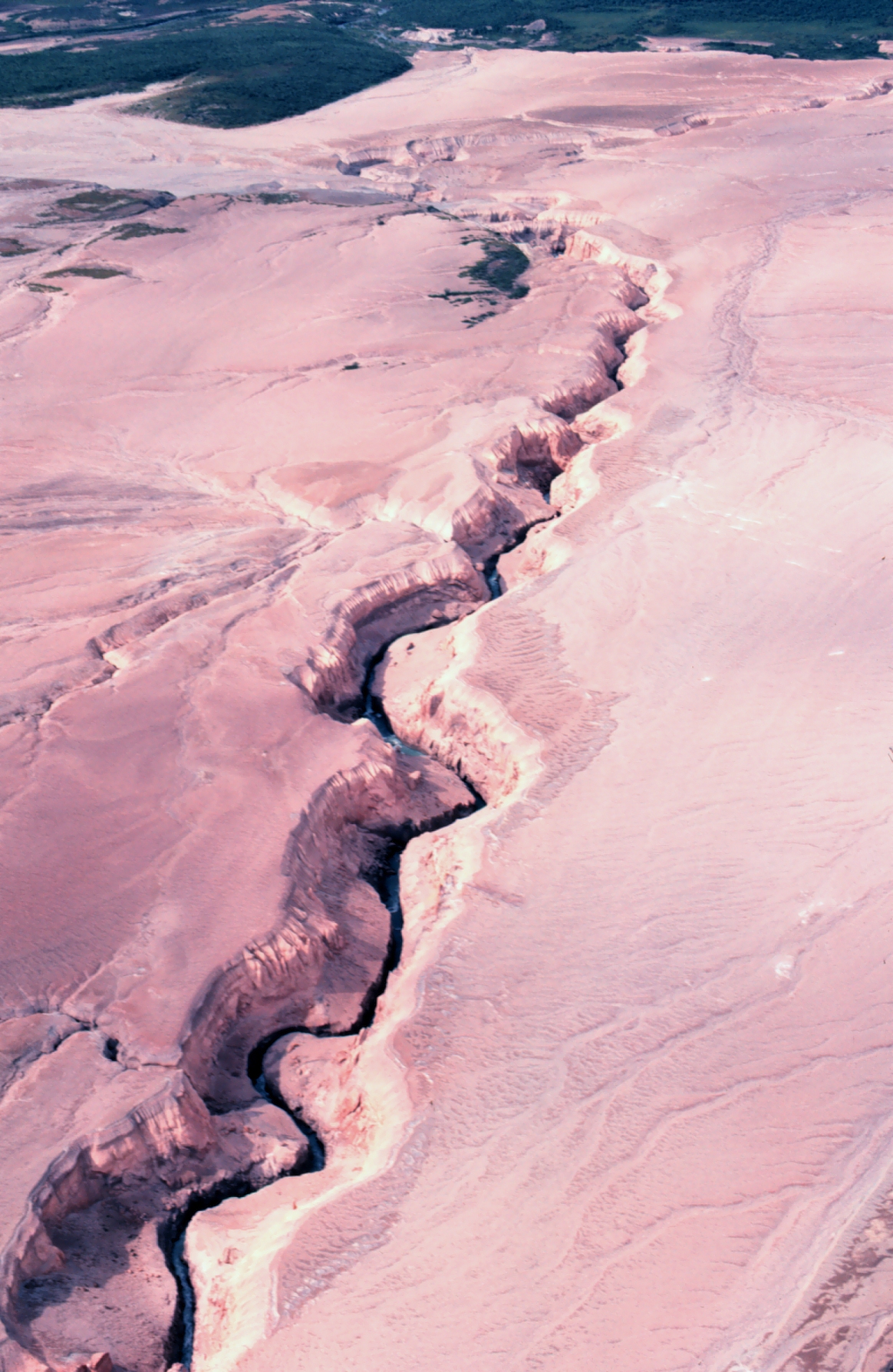
The ten thousand smokes have long since stopped smoking - the ash cooled within decades, and the fumaroles died. But the valley remains a volcanic moonscape over a century later. The ash flows hardened into a surface called ignimbrite, hostile to plant life. Erosion has carved canyons through the ash, revealing colorful layers of deposited material. Vegetation creeps in at the edges, but the valley floor remains largely barren. The recovery will take centuries more - if it happens at all. Some volcanic landscapes never fully return to pre-eruption ecology.
The Park
Katmai National Park and Preserve now encompasses 4 million acres, known more for bears than volcanoes. Brooks Camp's bear viewing draws most visitors; the Valley of Ten Thousand Smokes sees far fewer. The valley is accessible via daily bus tours from Brooks Camp (seasonal) - a 23-mile drive on a road built for scientific access. The journey takes visitors from green forests to gray desolation, illustrating the eruption's boundary as sharply as any photograph. Hiking into the ash flows is permitted; the solitude is profound.
Visiting the Valley of Ten Thousand Smokes
The Valley of Ten Thousand Smokes is located within Katmai National Park, accessible only by air. Floatplanes from King Salmon or Anchorage serve Brooks Camp, the park's hub. Bus tours to the valley depart Brooks Camp daily in summer (reservation required). The tour includes a stop at the valley overlook and time to hike onto the ash flows. Independent hiking requires backcountry permits. Brooks Camp has lodging and dining (expensive, book a year ahead). Camping is available with proper bear-safety equipment. Bear viewing at Brooks Falls is the park's main attraction; the valley offers geological wonder for those willing to add the bus tour. Visit July through September; earlier visits may encounter snow in the valley.
From the Air
Located at 58.35°N, 155.10°W on the Alaska Peninsula. From altitude, the Valley of Ten Thousand Smokes appears as a gray expanse amid green forests - the ash flows clearly distinct from surrounding vegetated terrain. Erosion canyons cut through the ash surface. Novarupta dome is visible at the head of the valley; Mount Katmai's caldera and lake are visible nearby. The contrast between the valley's desolation and the lush terrain surrounding it illustrates the eruption's boundaries. Brooks Camp and Naknek Lake are visible to the west. This was the largest eruption of the 20th century; from altitude, the scale is visible as miles of gray interrupting green.