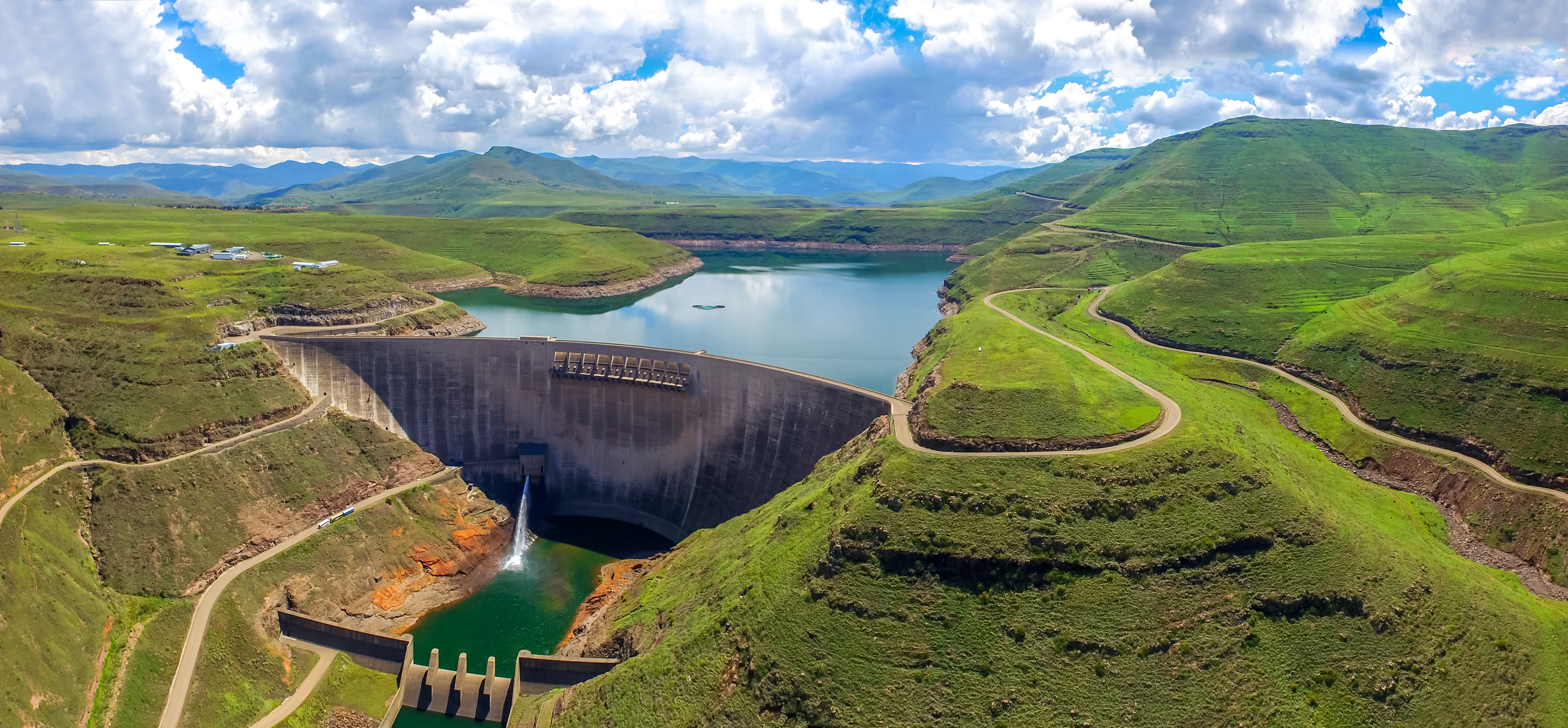
Katse Dam
In 1953, a South African civil engineer named Ninham Shand looked at the mountains of Lesotho and saw not rock, but leverage. The tiny landlocked kingdom sat thousands of feet above South Africa's industrial heartland on the Witwatersrand, and its rivers ran heavy with water that the parched lowlands desperately needed. What if Lesotho could sell its altitude? Four decades later, that idea became concrete -- literally. Katse Dam, a double-curvature arch rising from the gorge of the Malibamatso River, turned gravity into a national export.
Water for Sale
The Lesotho Highlands Water Project was born from a geographic accident and a political calculation. Lesotho, entirely surrounded by South Africa, possessed abundant mountain rainfall but almost no industry. South Africa had the opposite problem: the Witwatersrand, its economic engine, was one of the driest populated regions on the continent. The World Bank brokered a treaty between the two nations, and construction began on what would become one of Africa's most ambitious engineering projects. A seven-company international consortium -- firms from France, South Africa, Germany, and Italy -- built the dam between the late 1980s and 1996. The reservoir filled by 1997, and on 22 January 1998, water delivery to South Africa officially began. Today the dam supplies roughly 30 cubic meters per second to its neighbor, earning Lesotho approximately $35 million per year in royalties.
An Arch Between Mountains
Katse Dam is a double-curvature concrete arch, Africa's second largest of its kind after Ethiopia's Tekeze Dam. The site was chosen for one overwhelming reason: elevation. At over 2,000 meters above sea level, Katse is the highest dam in Africa, and its altitude allows water to flow to South Africa entirely by gravity through a 45-kilometer tunnel with a 4-meter diameter. No pumping stations, no energy costs for transport -- just physics. At the tunnel's exit near Muela, the falling water spins turbines at a hydroelectric station, generating power for Lesotho before continuing its journey south. The dam is part of a larger scheme that will eventually include five major dams across Lesotho's remote highlands, though Katse remains the centerpiece.
The Weight of Water
Engineering triumphs rarely come without human costs, and Katse Dam's legacy is no exception. The sheer mass of water impounded behind the arch triggered induced seismicity -- earthquakes caused by the reservoir's weight pressing into the earth. Farmers who had worked the valley for generations lost their land to the rising waters. In the mountains, arable land is scarce, and replacement plots proved hard to find. Efforts to establish new livelihoods for displaced communities have struggled to match the ambition of the engineering works themselves. International Rivers, a nonprofit watchdog, documented the social fallout in detail, while a local organization, the Transformation Resource Centre, has tracked the project's human legacy in the affected highland communities. A corruption scandal further tarnished the project's reputation: Lesotho's courts took the unusual step of prosecuting several multinational construction firms, alongside a local bureaucrat, for bribery. Multiple convictions followed, and at least one company was debarred by the World Bank.
A Garden from the Flood
Before the reservoir swallowed the valley, botanists raced against the rising waterline. Plant rescue missions combed the slopes that would soon disappear, collecting specimens of the mountain flora that had adapted to Lesotho's harsh altitude over millennia. The rescued plants found a new home at Katse Botanical Gardens, established as mitigation for the loss of habitat. The garden now propagates species that might otherwise have vanished beneath the reservoir's surface, a living archive of a landscape that no longer exists. It is a small counterweight to the scale of transformation -- a reminder that the valley below the dam's arch once held something other than water.
The Intake Tower's Quiet Work
Roughly 18 kilometers north of the dam wall stands the intake tower, a 98-meter cylinder designed to draw water from four distinct levels of the reservoir. This design allows operators to control water quality regardless of seasonal fluctuations, selecting cleaner strata as conditions change. The tower can handle up to 70 cubic meters per second -- the maximum throughput originally envisaged for the full water project. Below the lowest draw-off point sits roughly 430 million cubic meters of dead storage, water that the transfer tunnels cannot reach. The reservoir's total capacity is 1,950 million cubic meters, of which 1,520 million is usable. Even the water that cannot be moved serves a purpose: it provides ballast, keeping pressure on the dam's foundations and maintaining the structural equilibrium that holds the arch in place.
From the Air
Katse Dam (29.337S, 28.506E) sits in the highlands of Lesotho at over 2,000 meters elevation. The reservoir is a striking blue feature visible against the brown and green mountain terrain. Approach from the west to see the double-curvature arch spanning the Malibamatso River gorge. Katse Airport (FXKA) lies 3 km southeast of the dam, built specifically to support construction. Maseru Moshoeshoe I International Airport (FXMM) is approximately 100 km to the west. The tunnel route running 45 km southwest to the Muela hydroelectric station is not visible from the air, but the reservoir's western arm formed by the Bokong River confluence is a clear landmark.