Kauhako Crater
In September 2011, park rangers noticed something wrong with the lake at the bottom of Kauhako Crater. Its surface was covered in a white film, and the air above it smelled of rotten eggs. Hydrogen sulfide, normally trapped deep below, had risen to the surface. Within weeks, every shrimp, every copepod, every strand of phytoplankton in the lake was dead. Dissolved oxygen levels plummeted from a supersaturated 227 percent to just 2.5 percent. No one had ever recorded anything like it in the lake's observed history. And then, after a heavy rain in mid-December, life briefly flickered back, only to vanish again two days later.
Born from the Ocean Floor
Kauhako Crater formed between 230,000 and 300,000 years ago, the product of eruptions from Pu'u 'Uao, an undersea volcano near what is now Molokai's north coast. The eruptions sent fast-flowing lava spreading outward from the ocean floor, building up the low shield that became the Kalaupapa Peninsula. The crater sits at the peninsula's center, its volcanic rim rising to roughly 500 feet above sea level, making it the highest point on this otherwise flat spit of land. The crater measures about 500 meters by 650 meters and tapers downward in a funnel shape. A kilometer-long lava channel, up to 150 meters wide and 30 meters deep, extends from the crater's northeastern rim and runs north, branching into smaller tubes and channels. This was the most recent volcanic episode on Molokai, occurring long after the island's massive sea cliffs had already formed.
The Deepest Small Lake
Lake Kauhako, nestled at the crater's bottom, holds a record that sounds impossible: it has the greatest depth-to-surface-area ratio of any lake on Earth, and it ranks as the tenth-deepest lake in the United States. The lake's shallower zones contain brackish water, rich in oxygen, where most of the crater's animal life resides, including small shrimp, plankton, and copepods. The deeper water is anoxic, sealed off from the atmosphere. A weak tidal connection links the lake to the ocean, and the peninsula beneath it rests on only a thin freshwater lens. Early visitors disagreed about the lake's basic character. Jules Remy, visiting in 1893, described it as saltwater. Nakuino, arriving in 1878, called it fresh. Both were partly right: the lake's chemistry shifts with rainfall, drought, and its subtle connection to the sea.
The Day the Lake Turned White
The National Park Service has monitored the lake's water quality four times a year since 2009. Nothing in those records prepared rangers for what they found in September 2011. The white layer covering the surface was hydrogen sulfide, a toxic gas normally locked in the lake's deep, oxygen-free zones. Something had caused the lake to overturn, bringing the poisonous lower water to the surface. Scientists believe the trigger was either a prolonged drought that evaporated the oxygenated surface layer, destabilizing the water column, or a landslide that disrupted the lake's stratification. The consequences were swift and total. By November, dissolved oxygen had crashed to near zero. Shrimp, phytoplankton, and other organisms died. No overturning event had been recorded in the lake's observed history, nor in any known historical accounts.
A Crater in the Forest
Above the waterline, Kauhako Crater is a forested bowl struggling between native and invasive species. The wiliwili tree, native to Hawaii, still grows on the crater's slopes, but it is outnumbered by Brazilian peppertree and big-sage lantana, both aggressive invaders. Black rats have been documented destroying native plants in the crater, particularly the endemic Reynoldsia sandwicensis. The crater's ecology mirrors the broader story of Hawaiian conservation: a landscape where what is native and what was brought in exist in uneasy tension. The lake itself told a similar story in December 2011. After heavy rain on December 14, the water turned green with a bloom of phytoplankton, and shrimp briefly reappeared. By December 16, the life was gone again, the lake returned to its bluish-green stillness. Whether the lake has fully recovered or remains in some altered state is a question the Park Service continues to monitor.
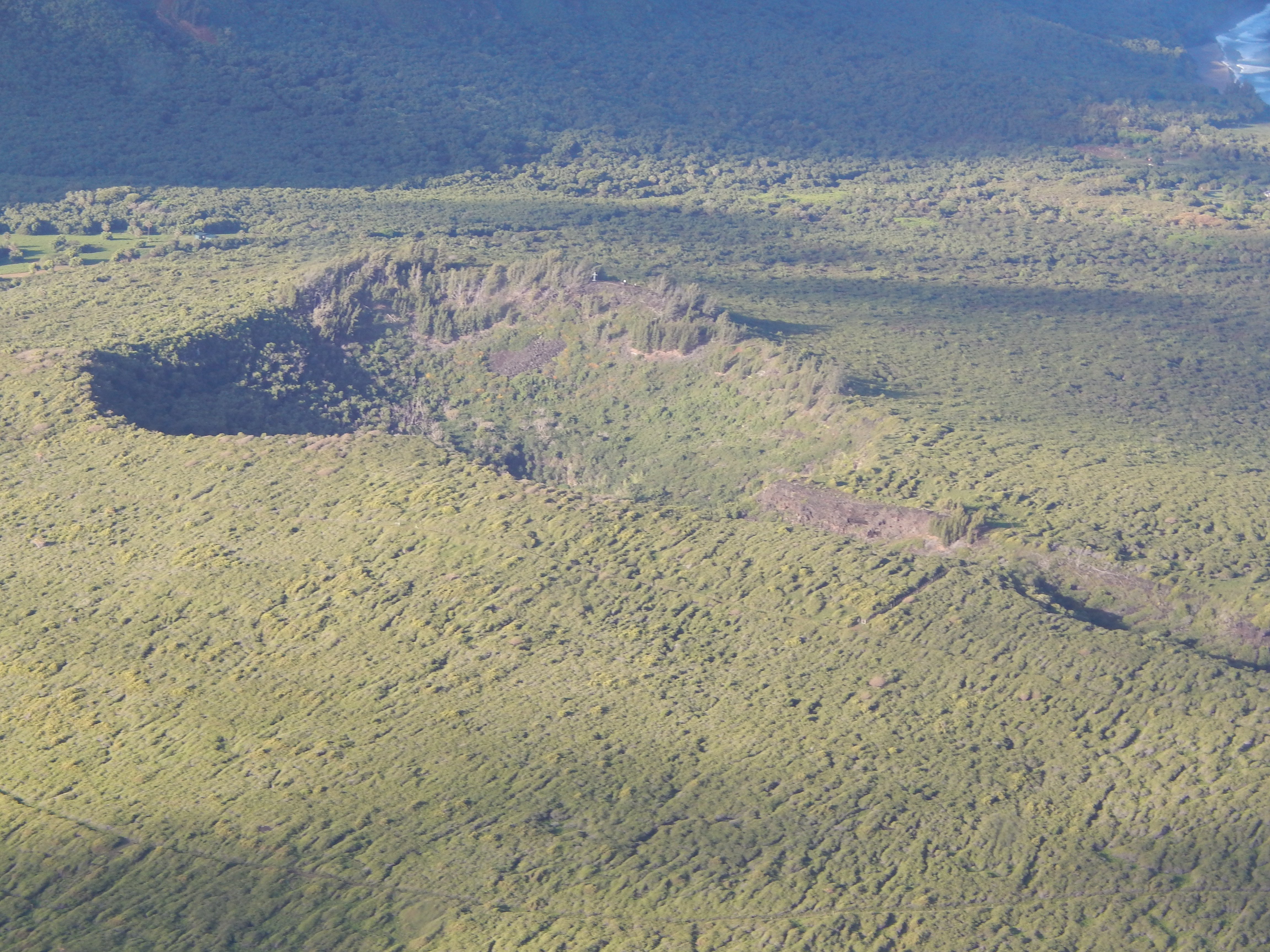
From the Air
Kauhako Crater is located at approximately 21.19N, 156.97W at the center of the Kalaupapa Peninsula on Molokai's north coast. From altitude, the crater appears as a forested depression at the peninsula's highest point, roughly 500 feet above sea level. The crater rim is visible as a slightly elevated ring on the otherwise flat peninsula. Lake Kauhako may be visible within the crater depending on angle and light conditions. The nearest airport is Kalaupapa Airport (PHLU), adjacent to the peninsula. Approach from the north for the best view of the crater in relation to the surrounding cliffs.