Kawachi Kokubun-ji
In 741 AD, Japan was burying its dead by the tens of thousands. The smallpox epidemic of 735-737 had torn through the islands, killing an estimated one-third of the population and decimating the ruling Fujiwara clan. Emperor Shomu's response was not just medical but spiritual: he ordered a Buddhist monastery and nunnery built in every province of Japan, a network of sacred architecture meant to invoke divine protection for a shattered nation. One of those temples rose on a steep hillside above the Yamato River in what was then Kawachi Province -- today the city of Kashiwara in eastern Osaka Prefecture. The monks are gone. The buildings are gone. The temple itself vanished so completely that by the Edo period, nobody remembered where it had stood. But the pagoda's stone foundation endured, and it tells a story of imperial ambition carved in tuff.
An Emperor's Spiritual Shield
The Shoku Nihongi, one of Japan's foundational historical chronicles, records Emperor Shomu's decree establishing the kokubunji system. Every province would receive a state-sponsored monastery and a companion nunnery, built to a semi-standardized template. These were not simple places of worship. They were instruments of centralized power under the Ritsuryo legal system, projecting the authority of the Nara-period imperial court into distant provinces through the universal language of Buddhist orthodoxy. The Kawachi Kokubun-ji sat on the left bank of the Yamato River, on a plateau extending north from the Myojin Mountains along the border between modern Osaka and Nara Prefectures. The provincial nunnery, the Kokubun-niji, is estimated to have stood about 900 meters to the west, though no physical remains have been confirmed. The Kawachi provincial capital at Kokufu, located roughly four kilometers to the northwest in what is now Fujiidera, administered the entire system.
A Temple Built on a Slope
Archaeological excavations beginning in 1934 have revealed the foundations of a main hall and a pagoda, but the full temple layout remains unclear. What makes Kawachi Kokubun-ji unusual among the kokubunji network is its terrain. Most provincial temples occupied broad, flat ground befitting their grand ceremonial purpose. This one clung to a steep hillside, and the usable flat surface within the estimated temple grounds is narrow. The choice of location suggests either a deliberate preference for the dramatic Yamato River overlook or practical constraints that forced the builders onto less-than-ideal ground. Excavated roof tiles from the site bear a striking resemblance to those found at the presumed Takeharaitonomiya palace across the river, where Emperor Shomu himself maintained a residence -- a tantalizing hint that the same craftsmen may have served both the emperor and his provincial temple.
Fading from Memory
The temple was built in the mid-8th century, but evidence of an earlier predecessor structure has also been confirmed on the site. The Engishiki records of 927 mention the temple, stipulating revenues of 10,000 bundles of rice for its upkeep -- a substantial endowment that speaks to its continuing importance nearly two centuries after construction. Records of its landholdings in Izumi Province appear in documents from 1109 and 1207. Then silence. The temple drops entirely from the historical record. By the Edo period, its very location had been forgotten, the hillside reclaimed by vegetation and time. A successor temple bearing the same name was eventually built 1.1 kilometers to the northeast, carrying the spiritual lineage forward even as the original site slept undisturbed beneath the soil.
The Pagoda Base That Outlasted Everything
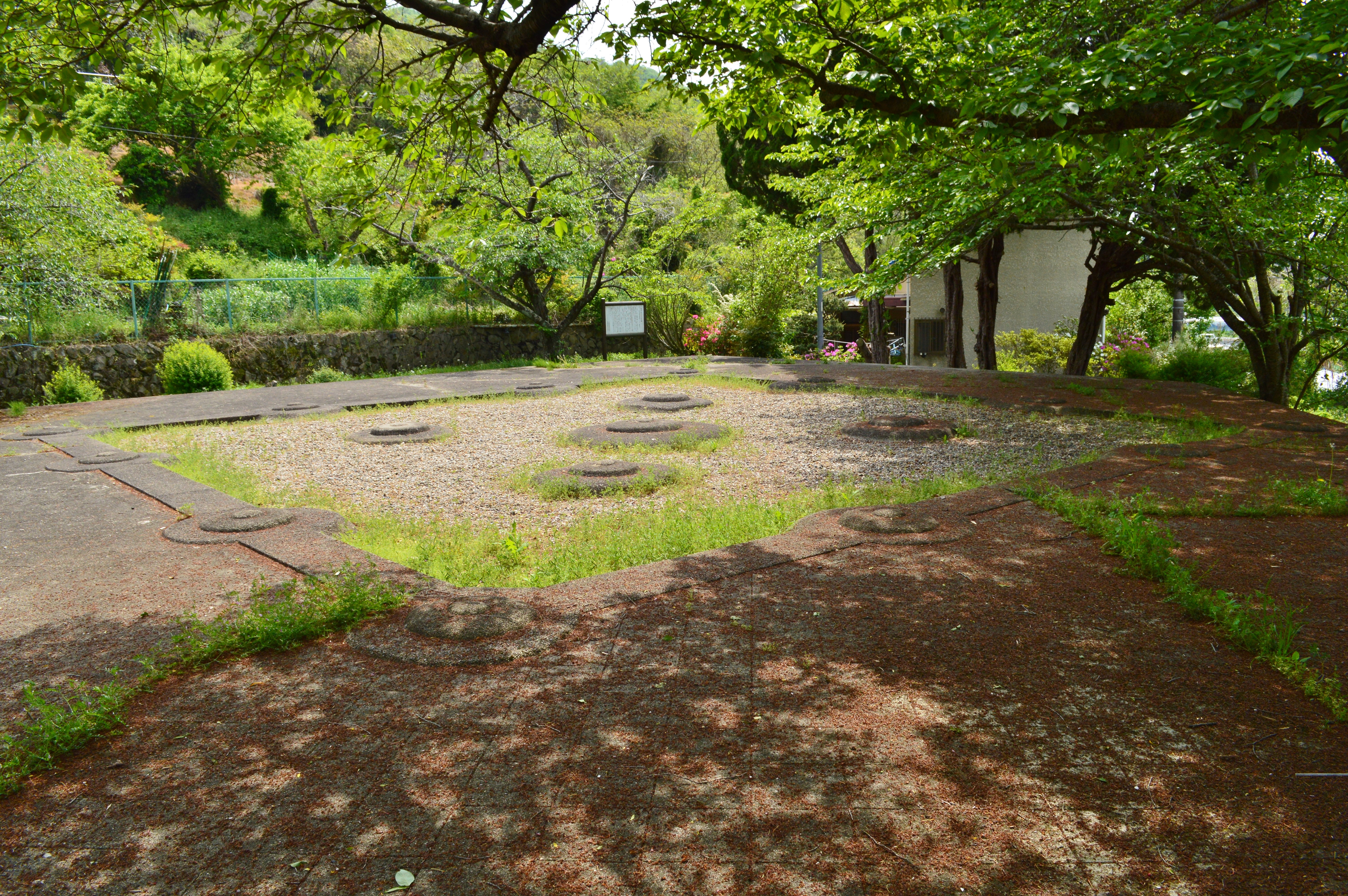
The most impressive surviving element is the pagoda foundation, a platform of cut tuff stones measuring approximately 19 meters on each side and 1.54 meters high, with six steps on every face. The top surface is paved in square tuff blocks laid in a diagonal lattice pattern. Six cornerstones remain in place, including the central foundation stone, and from their spacing, archaeologists estimate the structure above measured 10.36 meters square at its base -- large enough to support what is believed to have been a seven-story pagoda. The scale is remarkable for a provincial temple. Today the pagoda base stands open to the public as a small historical park in Kashiwara's Higanjo-cho neighborhood. The excavated roof tiles have been designated a Tangible Cultural Property by Osaka Prefecture. Standing on the ancient platform, looking out across the Yamato River toward the mountains where emperor and monk once shared the same skyline, the stone underfoot feels like the last sentence of a book whose earlier pages have been lost.
From the Air
Located at 34.57N, 135.66E on a hillside above the Yamato River in eastern Osaka Prefecture, in the city of Kashiwara near the border with Nara Prefecture. The pagoda base and small park are difficult to spot from high altitude but the Yamato River corridor serves as an excellent visual reference. Osaka Itami Airport (RJOO) lies approximately 25nm to the north-northwest; Kansai International Airport (RJBB) is roughly 30nm to the southwest; Yao Airport (RJOY) is approximately 8nm to the west. Best viewed at 2,000-4,000 feet AGL. The Myojin Mountains and the Osaka-Nara prefectural border ridgeline provide context to the east.