Kebnekaise
The Sami called it Giebmegaisi -- Cauldron Crest -- and the name fits. Kebnekaise's twin summits trap clouds and weather between them like steam rising from a vast stone pot, 150 kilometers north of the Arctic Circle in Swedish Lapland. What makes Sweden's highest mountain unusual is not just its height but the fact that its height keeps changing. The glaciated southern peak, long the undisputed summit, has been shrinking for decades as its cap of ice melts away. The northern peak, bare rock at 2,096.8 meters, waits patiently below -- or perhaps alongside, depending on the year you visit. In a country known for stability, the nation's rooftop is anything but stable.
A Summit in Flux
For most of recorded history, the southern peak stood taller. Early measurements placed it at 2,117 meters, and for generations that number was the answer to a simple geography question. But the glacier crowning that rocky plateau has lost 24 meters of height over the past half century. By recent measurements, the southern summit has fallen well below its northern neighbor -- losing 3.1 meters in 2024 alone, with the gap now exceeding 8 meters. In some years the ice grows back slightly; in others it retreats further. Researchers at nearby Tarfala Research Station track these fluctuations with the precision of a patient monitoring vital signs, and the diagnosis is clear: the long-term trend points downward. The northern peak, fixed in solid rock, does not budge. Since 2019, it has been Sweden's undisputed highest point. The mountain has turned a textbook fact into an open question.
Ice, Rock, and Permafrost
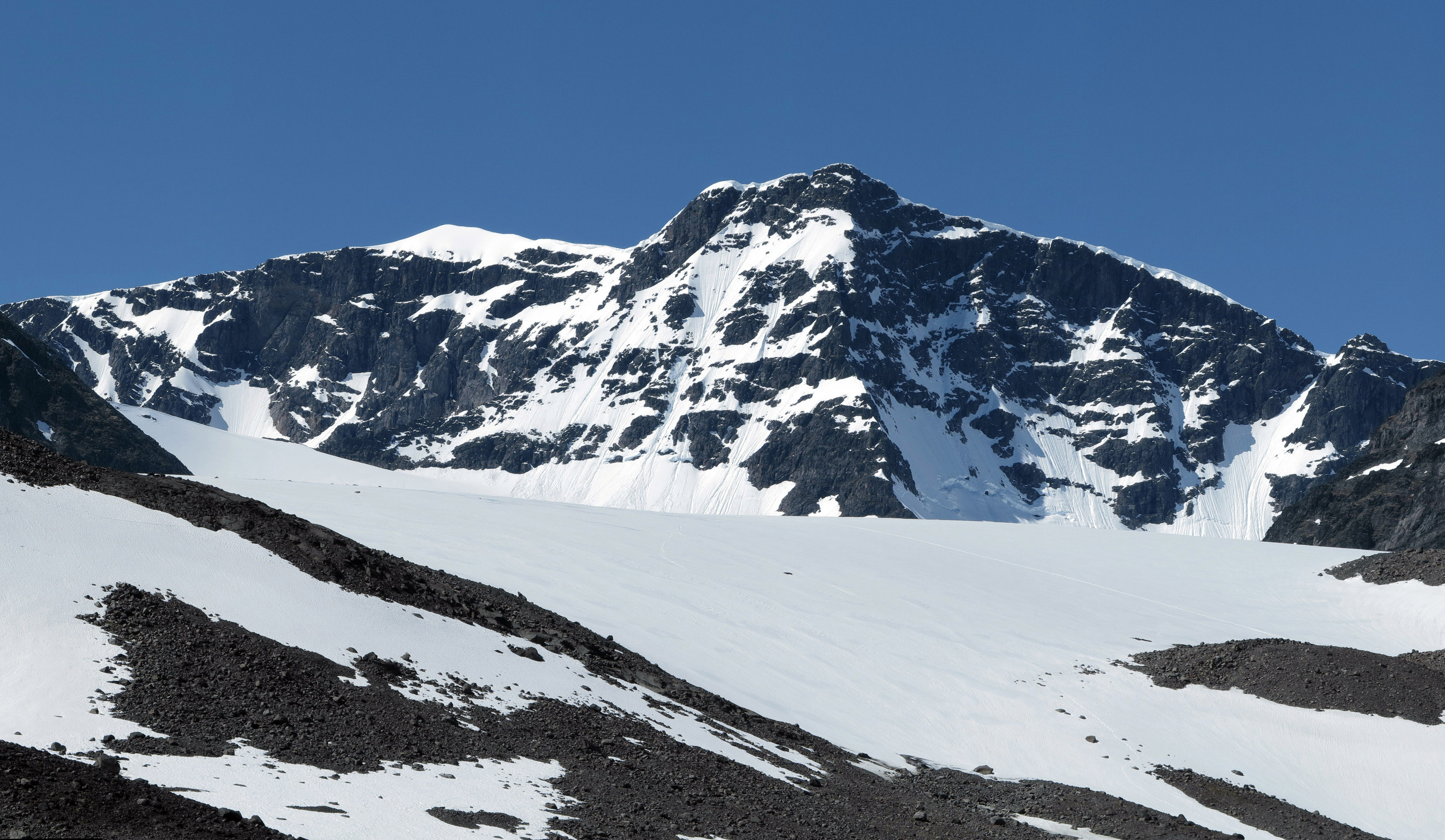
Kebnekaise is not a lone spire but a massif -- a sprawling complex of ridges, glacial valleys, and subsidiary peaks flanked by some of Sweden's most studied glaciers. Storglaciaren, Isfallsglaciaren, and Rabots glaciar cling to its slopes, feeding meltwater into the Tarfala Valley to the east. Permafrost runs deep here. A borehole drilled at 1,540 meters holds steady at minus 2.75 degrees Celsius a hundred meters down, suggesting frozen ground extending more than 330 meters beneath the surface. The massif sits within a ring of glacial valleys whose Sami names -- Laddjuvaggi, Ceakcavaggi, Visttasvaggi -- speak to the long human familiarity with this landscape. On a clear day from the summit, some sources claim you can see nine percent of Sweden spread out below.
First Footsteps
The first recorded ascent came on 22 August 1883, led not by a Swede but by the French explorer Charles Rabot, accompanied by three local men: Jon Larsson, Hans Monsen, and Peder Abrahamsson Lindgren. They approached from the Norwegian side, via the Skjomen fjord, because no railway yet existed in the region. That first climb went largely unnoticed. It was not until Johan Alfred Bjorling led a Swedish expedition to the summit on 9 July 1889 that the mountain gained national attention. The Kebnekaise mountain lodge opened in 1908, and from then the peak became a destination rather than a rumor. Today two main routes lead to the southern summit: the western trail, a strenuous but straightforward hike over scree and the intermediate peak Vierranvarri, and the eastern route, a more technical climb over glaciers equipped with fixed steel cables. The fastest known round trip from the lodge stands at 1 hour 47 minutes, set by Petter Engdahl in July 2020.
Danger on the Mountain
Kebnekaise's subarctic climate demands respect. The climbing season runs from late June to early September, and even then conditions can turn lethal. The peak glacier sits atop a nearly flat plateau that drops away sharply on the eastern side -- a void that has claimed lives when hikers lost traction on ice and slid into it. The danger is not always obvious, even in good visibility. Winter brings a different character entirely: guided skiing tours and alpine expeditions replace the summer hikers. On 15 March 2012, the mountain's dangers extended beyond its slopes when a Royal Norwegian Air Force C-130J Hercules crashed into the western face just below the ridge connecting the two summits, killing all five crew members. A small cabin at 1,880 meters, built in 1924, still stands near the summit plateau. A larger cabin beside it was demolished in 2018 after years of wear, replaced by a new structure opened in 2016 higher on the plateau.
The View from Above
From the air, Kebnekaise reveals its full architecture: the sharp ridge called Vargryggen connecting the twin summits, the glaciers splayed outward like white fingers, the dark lakes filling the valleys below. The Kungsleden hiking trail passes nearby, linking Abisko to the north with Hemavan far to the south, and Kebnekaise sits at the heart of the route's most dramatic stretch. Kiruna, Sweden's northernmost city and home to the world's largest underground iron ore mine, lies to the east. The massif anchors a landscape where the Sami have herded reindeer for centuries and where modern science now monitors some of the clearest signals of a warming Arctic. Whether the southern peak holds its crown or surrenders it depends on forces far larger than one mountain -- but it is this mountain, more than any other in Scandinavia, that makes those forces visible.
From the Air
Kebnekaise is located at 67.88°N, 18.55°E in Swedish Lapland, approximately 150 km north of the Arctic Circle. The massif rises to roughly 2,097 m and is the highest terrain in Sweden. Nearest major airport is Kiruna (ESNQ), approximately 70 km to the east. Approach from the east for the best view of the glaciated western face and the twin summits. Maintain safe altitude above 8,000 ft AGL given the mountainous terrain. Weather can change rapidly; be prepared for sudden cloud cover and strong winds. The Kungsleden trail and Tarfala Valley are visible landmarks. Lake Tornetrask lies to the northwest.