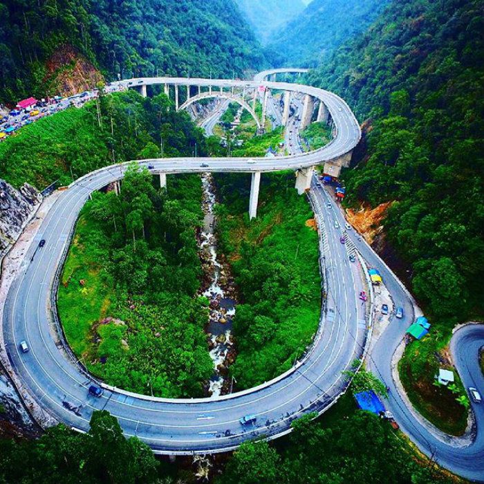
Kelok 9
Nine turns. That is all that separates West Sumatra from the eastern lowlands of Riau -- nine hairpin bends carved into the flank of the Barisan Mountains, each one tighter than the last. The road known as Kelok Sembilan has threaded through these switchbacks since the Dutch colonial government built it between 1908 and 1914, and for a century, every truck driver, every bus passenger, every farmer hauling livestock to market has white-knuckled through the same sequence: ravine on one side, hillside on the other, and the next curve already approaching.
Three Hundred Meters as the Crow Flies
The geometry of Kelok 9 tells the story of Sumatra's spine. The Barisan Mountains run the length of the island from north to south, and any road connecting the western coast to the eastern plains must cross them somewhere. Here, about 30 kilometers east of Payakumbuh in Lima Puluh Kota Regency, the engineers of the Dutch East Indies found their route -- but the terrain demanded a price. If you stretched the nine turns into a straight line, the distance would be only 300 meters. The road itself is just 5 meters wide, climbing roughly 80 meters in elevation. Two nature reserves flank the passage: the White Water Reservation and the Harau Nature Reserve. From above, the switchbacks look like a ribbon someone crumpled and dropped between the hills.
The Bottleneck That Choked an Economy
By the year 2000, the colonial-era road had become a chokepoint for one of Sumatra's busiest trade corridors. Between 9,000 and 11,000 vehicles passed through daily, carrying an estimated 15.8 million people and 28.5 million tons of goods each year -- roughly half of it agricultural products and livestock moving from the interior to the coast and back. The narrow switchbacks turned what should have been a four-hour drive from Bukittinggi to Pekanbaru into five or six hours of grinding low-gear crawling, with breakdowns and accidents compounding the delays. The road was not just inconvenient; it was strangling the economic link between two of Sumatra's most important provinces.
Bridging the Gap
In August 2003, Indonesia's National Development Planning Agency approved what local authorities had long requested: a modern overpass system to leap over the old switchbacks entirely. Construction began that November and unfolded in two stages. The finished project stretches 2,537 meters, comprising six bridges totaling 959 meters and 1,537 meters of connecting roadway, all 12.5 meters wide. The fourth bridge is the engineering centerpiece -- a 462-meter concrete arch span anchored by bore piles driven 20 meters deep, designed to withstand the horizontal forces of earthquakes in this seismically active region. The entire project cost US$49.5 million. President Susilo Bambang Yudhoyono inaugurated the overpass in October 2013, a full decade after construction began.
Old Road, New View
The overpass did not replace Kelok 9 so much as float above it. The original switchbacks remain below, still passable, now quieter -- a relic of colonial-era engineering that once defined the rhythm of Sumatran overland travel. From the new bridges, passengers can look down at the hairpin turns their grandparents cursed, the ravines that swallowed unlucky vehicles, the narrow path that bottled up a modern economy. The contrast is striking: Dutch-era road below, twenty-first-century engineering above, and the Barisan Mountains unchanged on either side. For travelers on the Trans-Sumatran route, the crossing that once took an hour of anxious driving now passes in minutes. But the landscape remains as dramatic as ever -- green slopes falling away to deep valleys, the old road winding like a question the mountains finally answered.
From the Air
Located at 0.07S, 100.70E in the Barisan Mountains of West Sumatra, approximately 30 km east of Payakumbuh. The nine hairpin turns of the old road and the modern overpass bridges are clearly visible from the air, making this a striking visual landmark. Nearest major airport is Minangkabau International Airport (WIPT/PDG) approximately 100 km to the southwest. The terrain is mountainous with deep valleys; approach with caution in low visibility. Best viewed at 3,000-5,000 feet.