Keswick Dam
A British lord's name graces a concrete dam on the Sacramento River, four miles northwest of Redding, California. Lord Keswick ran the Mountain Copper Company that once extracted metals from the nearby hills, and when the Bureau of Reclamation finished their gravity dam in 1950, they honored him with the name. Keswick Dam lives in the shadow of its famous upstream neighbor, Shasta Dam, serving as the afterbay that smooths out the erratic water releases from Shasta's power plant. Yet this humble structure faces a challenge Shasta never did: managing some of the most contaminated water in America, drainage from the toxic legacy of Lord Keswick's own mining operations.
The Little Dam That Could
Keswick Dam stands modest by California standards: a concrete gravity structure impounding a reservoir with capacity for 23,800 acre-feet of water. But its power plant punches above its weight class, generating 117 megawatts through three turbines, upgraded from the original 75 megawatts in 1992. The electrical substation at Keswick serves as a distribution hub for power from multiple sources: the Keswick plant itself, Trinity Dam, Lewiston Dam, the Judge Francis Carr Power plant at Whiskeytown Lake, and the Spring Creek Power plant just to the northwest. Construction began in August 1941, with Guy F. Atkinson and Kiefer Construction companies executing the Bureau of Reclamation's design. From various vantage points around the dam, two volcanic sentinels watch over the work: Mount Shasta to the north and Lassen Peak to the east.
Water Wars of the Central Valley
Keswick Dam exists because California discovered in the 19th century that its water arrived at the wrong time in the wrong places. Gold Rush immigrants who shifted from mining to farming found the Central Valley's flat, fertile land perfect for agriculture, except for one problem: winter floods gave way to summer droughts. Salt crept into the valley and San Francisco Bay as river flows dropped. The riparian rights law compounded the crisis, granting water rights only to landowners whose property bordered streams. The state legislature created the Central Valley Project in 1933 to redistribute water across the enormous north-south span from the Cascades to the Kern River. The federal government took over, funded by Depression-era emergency relief, and Keswick Dam became part of the Shasta Division, capturing water diverted from the Trinity River and stabilizing releases from Shasta Dam.
The Toxic Inheritance
Lord Keswick's Mountain Copper Company left behind more than a namesake. Iron Mountain Mine, adjacent to Keswick Reservoir, operated from the 1860s until 1963, extracting iron, gold, silver, copper, and zinc. The mining fractured the mountain and exposed sulfide ores to oxygen and water. The result: acid mine drainage so extreme that samples have registered a pH of negative 3.6. Contaminated sediments accumulated in Spring Creek Reservoir and Keswick Reservoir. Copper proved the main pollutant, but iron, zinc, cadmium, mercury, and lead joined the toxic mix. The Bureau of Reclamation coordinates releases from Spring Creek Reservoir to coincide with diluting flows from Shasta Dam, a delicate dance to prevent dangerous concentrations of heavy metals from reaching downstream communities.
Salmon's Last Stand
Keswick Dam marks the end of the road for salmon swimming up the Sacramento River. As the uppermost barrier to anadromous fish migration, the dam defines the spawning habitat for winter-run Chinook salmon, a federally endangered species. The reach from Keswick Dam south to Red Bluff contains most of the river's Chinook spawning grounds, making water temperature critical. Since 1993, the Bureau of Reclamation has managed cold-water releases to keep daily average temperatures at or below 56 degrees Fahrenheit between the dam and monitoring points downstream, protecting salmon eggs and juveniles from May 15 through September 30. Rainbow and brown trout inhabit Keswick Reservoir, along with warm-water species, though the small reservoir sees little fishing pressure.
Balancing Act
Keswick Reservoir rises and falls with the rhythm of power generation and agricultural demand. Daily fluctuations of one to three feet are routine; annual swings can reach eight or nine feet. Releases to the Sacramento River have ranged from 3,300 cubic feet per second during drought to 79,000 during flood events. The dam and its partner upstream control river flows below mile 302, transforming what was once a wild seasonal river into a managed resource. Sixty-nine inches of precipitation fall in an average year, most between October and March, while summer brings prolonged dry heat that drives agricultural water demand skyward. The area's farms need Keswick's regulated releases; the endangered salmon need its cold-water management; downstream communities need its protection from toxic mine drainage. Every day, the dam balances competing demands in a valley that has fought over water since the Gold Rush.
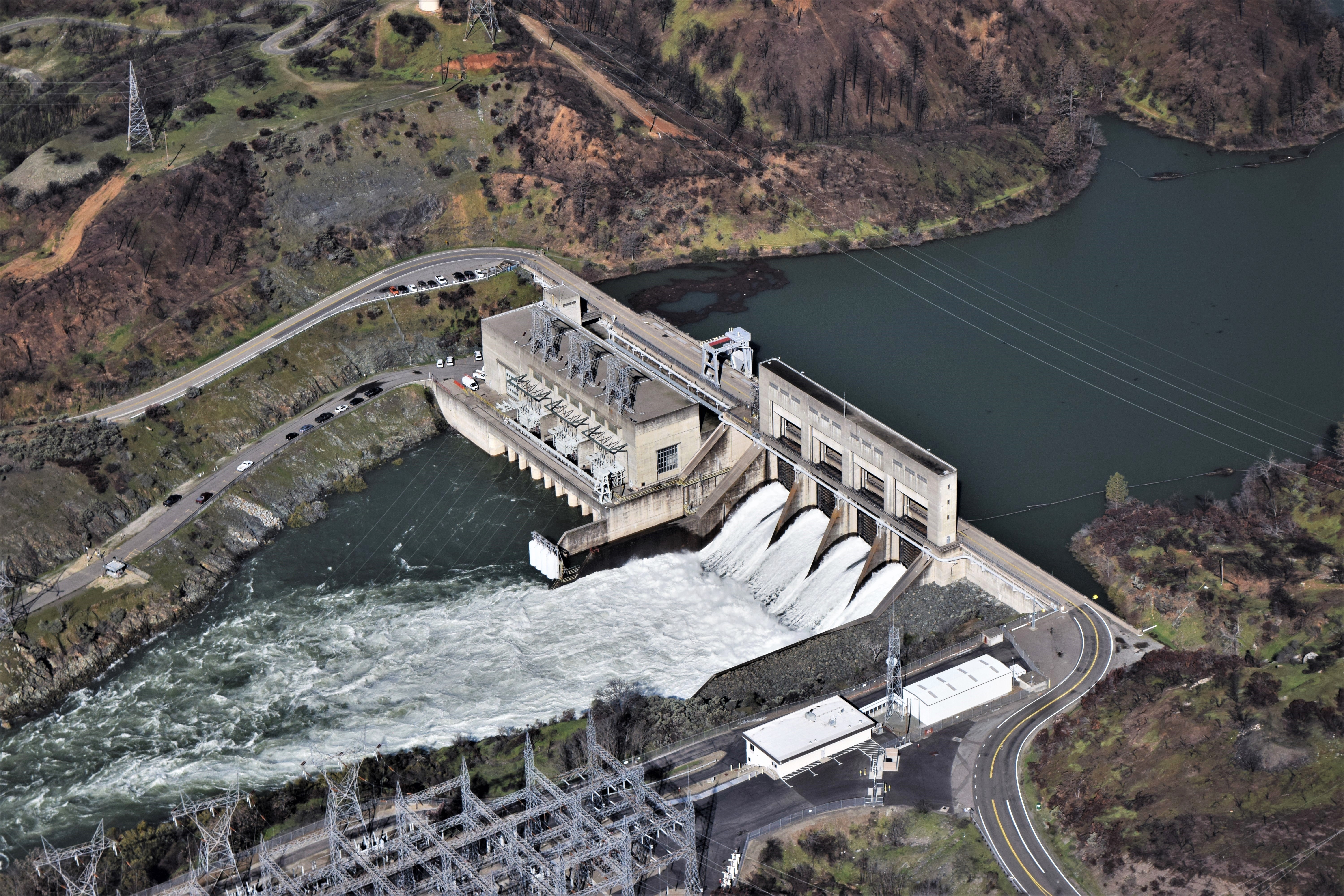
From the Air
Keswick Dam is located at 40.61N, 122.45W on the Sacramento River, approximately 4 miles northwest of Redding, California. The concrete structure is clearly visible from 3,000 feet, with Keswick Reservoir behind it and the Sacramento River flowing south toward Red Bluff. Shasta Dam and Lake Shasta dominate the view to the north; Mount Shasta rises on the horizon beyond. Iron Mountain Mine's scarred terrain lies to the northwest. Redding Municipal Airport (KRDD) is 6 nautical miles to the southeast. Clear weather offers views of both Mount Shasta and Lassen Peak from positions near the dam.