Kevo Strict Nature Reserve
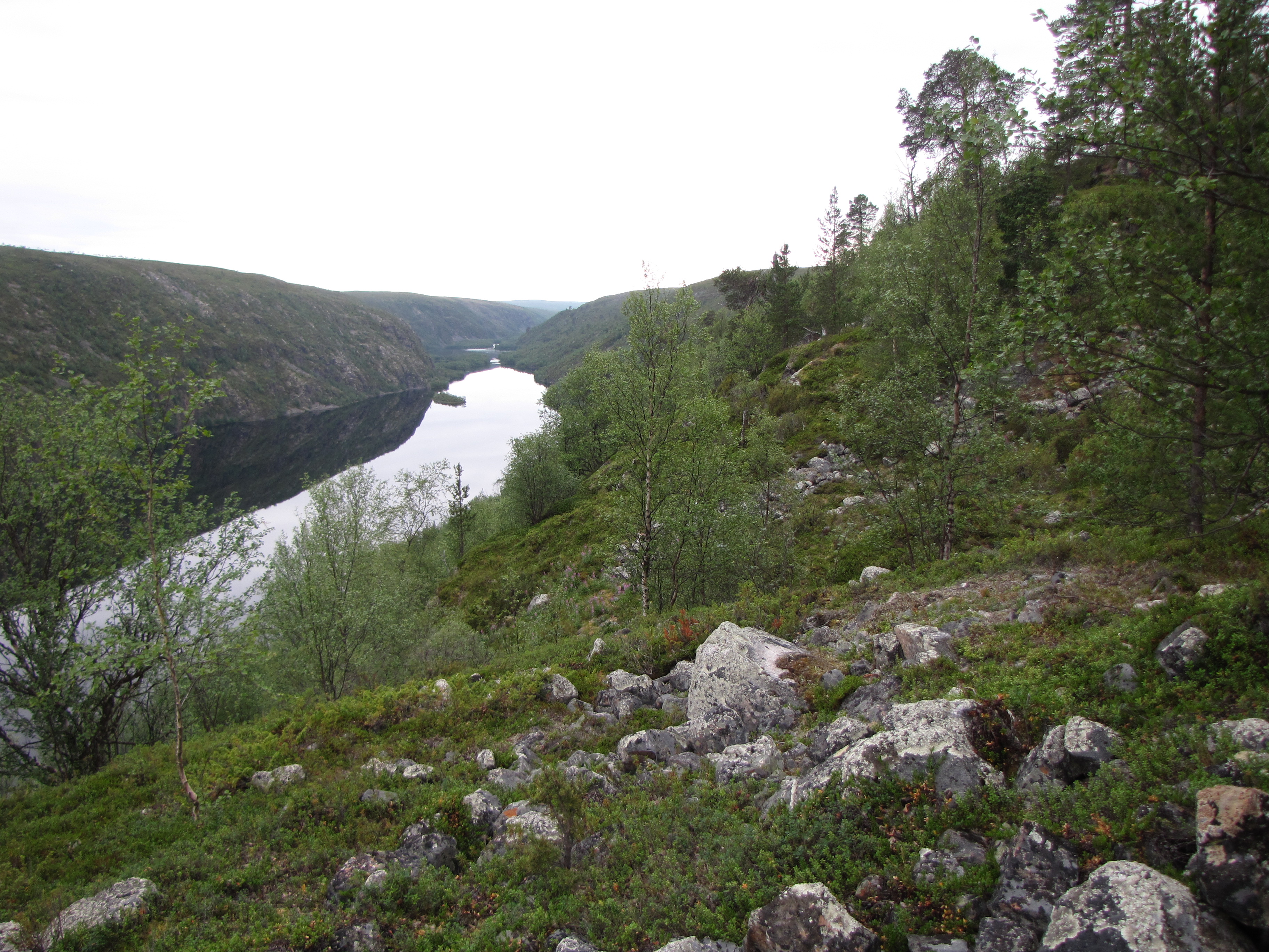
The gorge appears without warning. One moment you are crossing treeless fell country, the landscape a rolling monotone of lichen and dwarf birch, and then the earth drops away -- eighty meters straight down into a rift valley that stretches forty kilometers to the northeast. This is the Kevo Wall, the iconic reveal at the heart of Finland's largest strict nature reserve, and the reason hikers carry their tents for days through some of the most demanding terrain in Scandinavia. At 69 degrees north, in the municipality of Utsjoki at the very top of Finland, Kevo Strict Nature Reserve covers 712 square kilometers of wilderness where the rules are simple: stay on the marked trails, carry everything you need, and accept that if something goes wrong, help is a long time coming.
Seventy Million Years in Stone
The Kevo gorge is a rift valley formed by plate tectonics roughly 70 million years ago, long before the ice ages sculpted the rest of Finnish Lapland. The gorge runs 40 kilometers and drops as deep as 80 meters in places, creating a microclimate so sheltered that pine trees survive in its depths while the surrounding highlands remain bare. This temperature anomaly nourishes plant species found nowhere else in the region and makes the gorge a crucial nesting ground for rare birds -- hikers routinely spot rough-legged buzzards circling the thermals above the valley walls. Smaller rift formations scar the surrounding landscape, but none approach the scale of the main gorge. It is the kind of geological feature that makes the age of the earth tangible: older than the Himalayas, older than the Atlantic Ocean, still splitting bedrock in the subarctic dark.
Trails Through Empty Country
Two trails penetrate the reserve. The Kevo trail runs 63 kilometers from Sulaoja in the southwest to Kenesjarvi in the northeast, taking three to five days to complete. The Kuivi trail forms an 87-kilometer loop from Sulaoja, climbing to the 640-meter summit of Kuivi fell before rejoining the Kevo trail near the Fiellu waterfall -- one of Finland's tallest at 27 meters. Both routes demand river crossings by wading, steep ascents equipped with wooden staircases, and the kind of self-sufficiency that modern infrastructure has made rare. There are no bridges. There is no mobile phone signal across most of the reserve. Camping is restricted to official sites equipped with dry toilets, fireplaces, and pre-cut firewood, but no personnel and no other services. Hikers sign guestbooks at huts and shelters not for sentiment but for survival: if you disappear, those entries tell rescuers where to look.
A Land the Sami Shaped
Kevo has probably never been permanently inhabited, but it has never been empty either. Nomadic Sami people hunted wild reindeer across these fells for centuries, leaving traces that persist in every dimension of the landscape. Place names in Northern Sami -- Suttesaja, Geavu, Guivvi -- map a geography of use that predates Finnish sovereignty. Ancient trap pits, maintained for generations until hunting gave way to herding in the 19th century, still indent the ground beside the trail. On top of Kuivi fell sits a sacrifice cave whose purpose has outlived the memory of its last ceremony. The reserve was established in 1956, but the Sami relationship with this land is measured in millennia. Today, permanent residents of Utsjoki municipality still hold the right to pick berries and mushrooms within the reserve -- a privilege denied to visitors, and a quiet acknowledgment that protection and belonging are not the same thing.
Where the Birch Forests Died
In the mid-1960s, autumnal moth caterpillars devastated the mountain birch forests across an area exceeding 1,300 square kilometers in Utsjoki alone, with even greater losses on the Norwegian side. Entire hillsides that had been forest became treeless overnight, and some have never recovered. Dead trunks still lie on the ground more than sixty years later, gray and weathered, monuments to a biological catastrophe that reshaped the visible landscape more dramatically than any human intervention. The mountain birch -- gnarled, apple-tree-shaped, the only species tough enough to claim the title of tree at this latitude -- defines the border between forest and fell. Where it grows, there is shelter from wind and a sense of enclosure. Where the moths killed it, the openness is absolute. Walking from one zone to the other is like crossing a threshold between rooms with very different temperatures.
Five Thousand Visitors and the Midnight Sun
Roughly 5,000 people hike Kevo's trails each year, nearly all of them arriving during a narrow window in late August and early September when the mosquitoes have subsided and the autumn colors blaze across the tundra. From late May to late July the midnight sun never sets, bathing the landscape in continuous Arctic light, but the thermal summer does not begin until late June, and even then freezing temperatures and snow are possible. Winter brings the opposite extreme: temperatures routinely plunge below minus 40 degrees, and the lowest recordings have dipped past minus 45 Celsius. Daylight shrinks to a few hours of dim twilight. The University of Turku maintains a subarctic research station at Lake Kejovarvi near the reserve's northeastern corner, one of the Finnish Meteorological Institute's official weather stations, quietly measuring a climate that swings between endless light and nearly endless dark.
From the Air
Located at 69.58N, 26.72E in the extreme north of Finland, municipality of Utsjoki. From the air, the Kevo gorge is visible as a dramatic linear gash cutting northeast through otherwise flat fell terrain. The nearest airport is Ivalo Airport (EFIV), approximately 100 km to the south. Recommended viewing altitude 5,000-8,000 ft to see the full extent of the 40 km gorge. The treeless landscape makes the rift valley especially visible from altitude. In summer, midnight sun provides constant illumination; in winter, the area is in polar night. Norway border visible to the north.