Khabarovsk
The Chinese name for the place where Khabarovsk now stands was Yupi Dazi — 'Fishskin Tartars' — recorded by French Jesuit cartographers in 1709 after the indigenous Tungusic people who fished the Amur and wore garments made from fish leather. It was already ancient ground. Chinese expeditions had reached this confluence of the Amur and Ussuri rivers in the early 15th century; by the mid-17th century it had become a contested frontier between Cossack adventurers pushing east and the Manchu Qing Dynasty pushing north. The Treaty of Nerchinsk in 1689 ended that conflict and handed the region to China, where it remained for nearly two centuries. Then, in 1858, the Treaty of Aigun transferred it to Russia, and a military outpost called Khabarovka rose at the confluence. The explorers and settlers who came named it for Yerofey Khabarov, the Cossack who had led some of the bloodiest raids into the Amur Valley two centuries before.
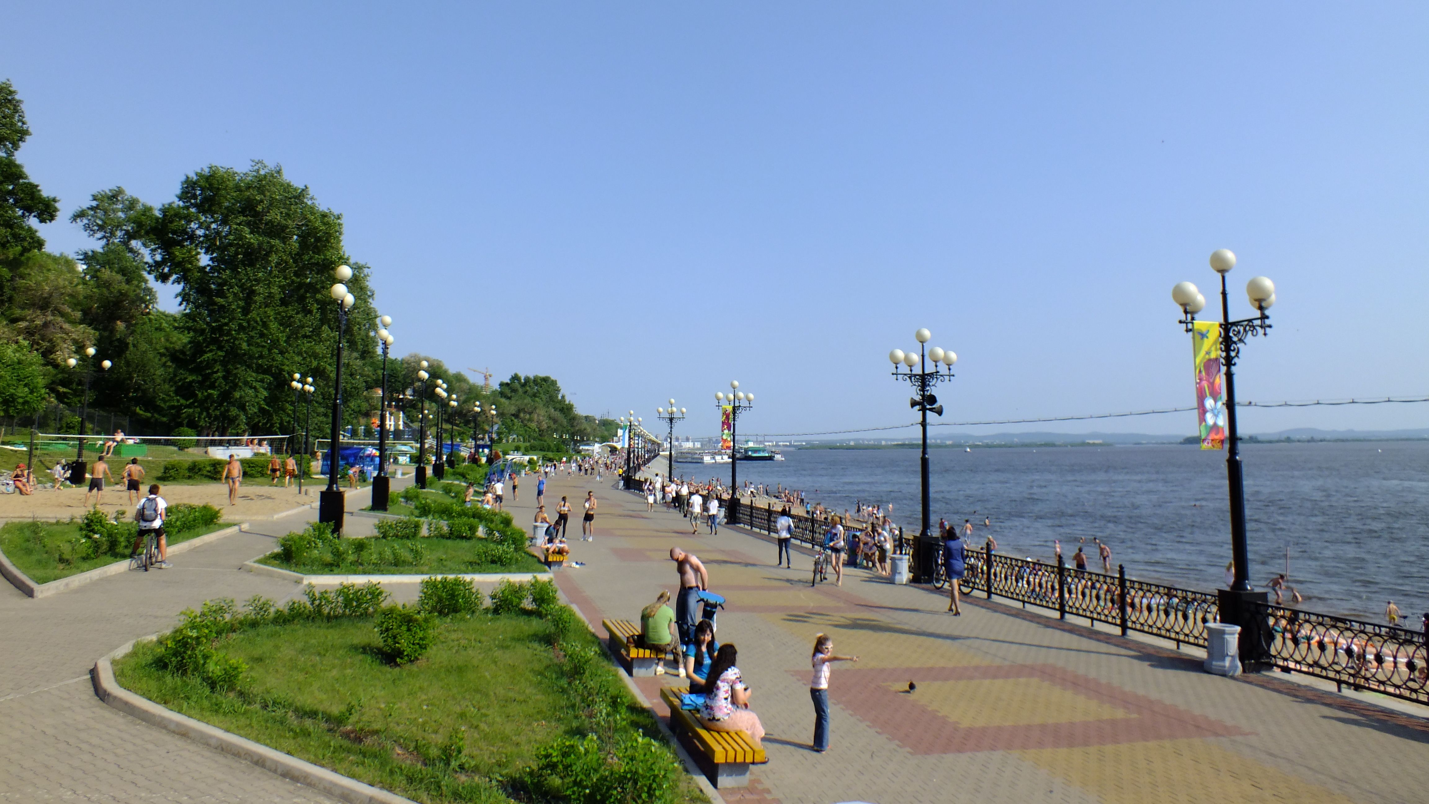
City at the Confluence
Stand at the river promenade and the logic of Khabarovsk's location becomes immediate. The Amur and Ussuri meet here, forming a broad brown ribbon of water visible from altitude as one of the most distinctive geographic junctions in Northeast Asia. The city approaches 600,000 residents, making it the second largest in the Russian Far East, and serves as capital of both Khabarovsk Krai and the entire Far Eastern Federal District. Unlike Vladivostok — which was closed to foreign visitors for decades as a military city — Khabarovsk has always been open, and retains an international character unusual in Russian provincial cities. Asian visitors have arrived in increasing numbers, seeking something Europeans might call 'a piece of Russia' while Russians call it a piece of Europe transplanted east. The result is a city spending generously on renovation, its pre-revolutionary classical buildings — spared much of the destruction of the 1917–23 civil war, partly because Japanese forces occupied the city during that period — now carefully restored along the main boulevard.
The Trans-Siberian's Eastern Terminus
The railway arrived from Vladivostok in 1897. The complete line to Moscow came in 1913, and three years later the Khabarovsk Bridge across the Amur was finished — its image eventually landing on Russia's 5,000-ruble banknote. The bridge ended the awkward arrangement of ferrying Trans-Siberian trains across the river. For travelers arriving by rail, Khabarovsk represents the end of the long traverse of Siberia and the beginning of the Far East, a distinct psychological and geographic threshold. The journey of nearly 8,500 kilometers from Moscow, crossing eight time zones, delivers passengers to a city on a bluff above a river that flows east toward the Pacific. Khabarovsk is UTC+10, seven hours ahead of Moscow — a fact the post office thoughtfully posts on its wall for travelers still adjusting to the scale of the country they've crossed.
Museums Better Than Moscow's Eastern Cousins
Clustered along Shevchenko Street behind the blue-domed Church of the Theotokos on Komsomolskaya Square, Khabarovsk's museum district occupies century-old pre-revolutionary buildings that would be remarkable even without their contents. The Far Eastern Regional Lore Museum houses one of the finest collections of indigenous Tungusic and Nanai cultural artifacts in Russia. The Natural History Museum documents the extraordinary biodiversity of the region — the Sikhote-Alin mountains nearby support one of the planet's most improbable ecosystems, where Siberian tigers share range with subtropical plant species. The Archaeology Museum, tucked away on Turgeneva Street behind the military museum, holds materials from excavations along the Amur that trace human occupation back thousands of years. The promenade below — lined in summer with open-air beer tents and live music — is a short walk from all of them.
Where Russia Looks East
Khabarovsk sits just kilometers from the Chinese border, and the relationship with China shapes daily life in ways that most Russian cities don't experience. Daily hydrofoils cross the Amur to Fuyuan in northeastern China in spring and summer. Over a million arrivals from Asian countries pass through annually. Local universities — including Pacific National University with over 21,000 students — maintain partnerships with Chinese, Japanese, and German institutions. The Japanese Center offers language courses that attract both Russians planning to visit Japan and Japanese visitors trying to understand Russia. Sixty-seven years after Soviet and Japanese forces last contested this region's ownership, the city has found a more productive way to navigate its position between two vast civilizations: it simply lets both in, and takes what's useful from each.
Nanai Country
Seventy kilometers upstream on the Amur, the Nanai village of Sikachi-Alyan marks the edge of Khabarovsk's immediate hinterland and the beginning of something older. The Nanai — indigenous people of the Amur valley who have fished these waters for millennia — live here alongside their ancestors' art: petroglyphs carved into the riverside basalt, some dating back 12,000 to 14,000 years. The drawings include mammoths, shamans, masks, horses, and geometric spirals. The village has a small museum covering Nanai shamanism, history, and material culture. The Wikivoyage guide to Khabarovsk offers this advice about the petroglyphs: if you can't find them, ask anyone in the village. Everyone will know where they are. It is a reminder that indigenous knowledge, however diminished by centuries of displacement and marginalisation, can still orient a traveler in ways that no GPS can replicate.
From the Air
Khabarovsk sits at 48.48°N, 135.07°E at the confluence of the Amur and Ussuri Rivers — one of the most visually distinctive geographic features in Northeast Asia, clearly visible from altitude. The Khabarovsk Novy Airport (UHHH) lies northwest of the city center. The long-span bridge across the Amur, depicted on Russia's 5,000-ruble banknote, is recognizable from altitude. China is visible across the river to the south. Recommended viewing altitude is 2,000–4,000 meters in clear weather.