Kharg Island
Carved into the coral rock of a small island in the northern Persian Gulf, five lines of Old Persian cuneiform script defy the usual orderly conventions of Achaemenid writing. Discovered in 2007, the inscription suggests that Persian colonists reached Kharg Island sometime between 550 and 330 BCE, bringing with them the qanat irrigation technology that the 17th-century French traveler Jean de Thevenot would later find still functioning. That single piece of carved coral connects an empire that once stretched from Egypt to India with a windswept island barely 20 square kilometers in size.
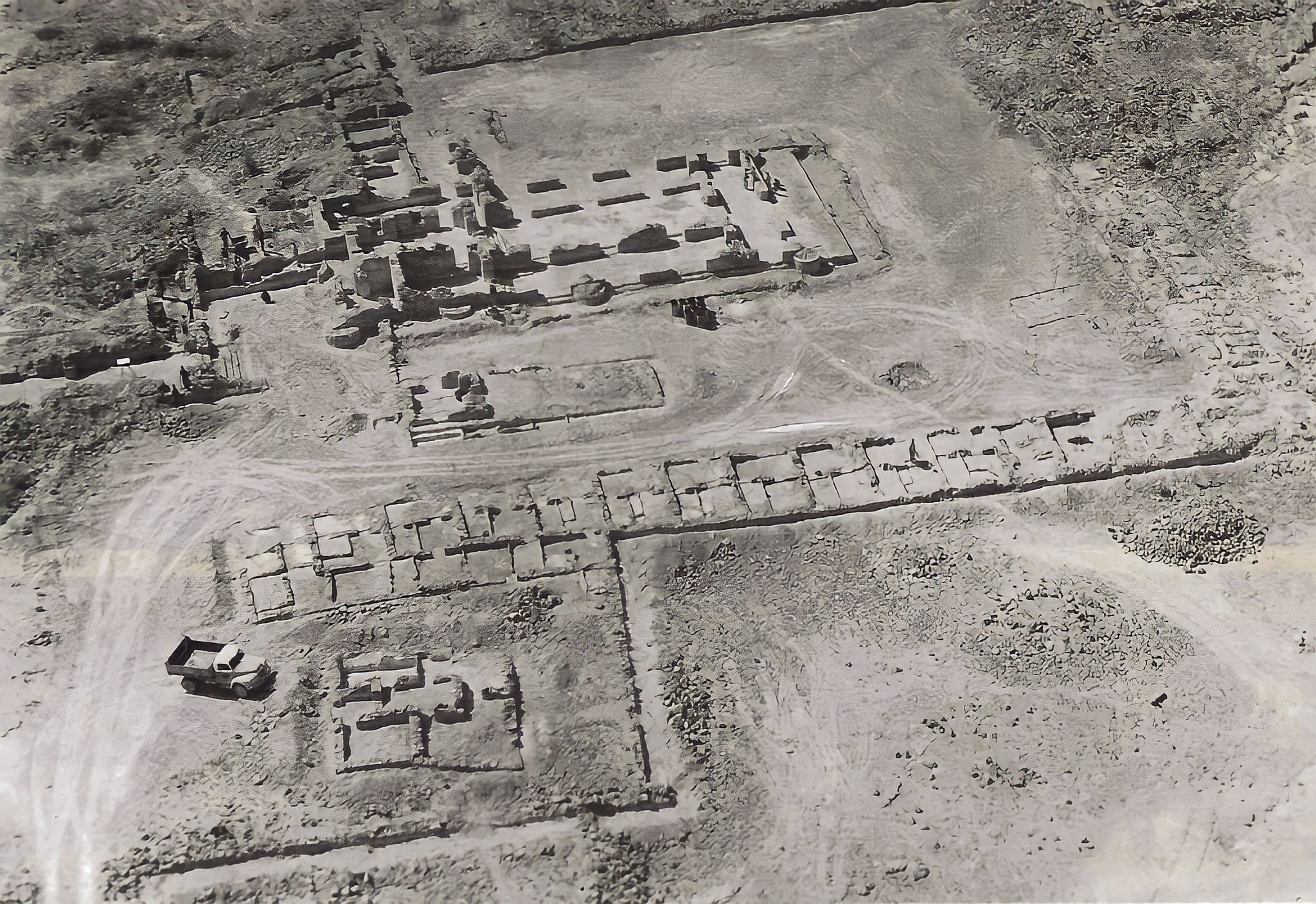
Tombs Older Than Memory
Captain A. W. Stiffe reported the first archaeological evidence of human occupation on Kharg in 1898, but what he found was no modest settlement. Subsequent studies by F. Sarre and E. Herzfeld in 1910 revealed two elaborate rock-cut chambered tombs with arched entranceways opening into main halls from which roughly twenty smaller chambers branched outward. In the southern tomb, a carved relief depicts a reclining man drinking, rendered in the Seleucid and Parthian styles of Palmyra. Nearby, a damaged figure that may represent Nike crowns a sphere-topped column. Scholars have counted eighty-three rock-cut tombs and sixty-two megalithic tombs across the island. The archaeologist Mary-Joseph Steve argued that the tomb architecture more closely resembles Nabataean work at Petra than anything from Palmyra -- an unexpected connection linking this Gulf island to the rose-red city carved into the sandstone cliffs of Jordan. Nestorian crosses carved at several tomb sites add another layer: early Christians passed through here too, leaving their mark alongside the drinking Parthians and the anonymous megalith builders.
Pearls, Pirates, and Empires
The 10th-century geographic text Hudud al-Alam mentions Kharg as a good source for pearls, placing the island on medieval trade networks around 982 AD. When Jean de Thevenot arrived in 1665, he recorded active commerce between the island and the cities of Isfahan and Basra. A century later, the Dutch had fortified the island, but in 1766, Mir Mahanna, the governor of Bandar Rig, seized their fort. The British occupied Kharg briefly in 1838, using it as leverage to block Persian advances during the Siege of Herat. They withdrew soon after. Each occupation left traces but none lasted. The island changed hands not because anyone wanted it for itself, but because its position in the Gulf made it useful for controlling what passed through the waters around it.
Black Gold and Bombardment
In the 20th century, Kharg's value shifted from pearls to petroleum. Amoco built and operated an oil terminal that grew into the world's largest offshore crude oil facility, handling the vast majority of Iranian exports. Then came the Iranian Revolution of 1979 and the nationalization of foreign oil assets. What revolution spared, war destroyed. From 1980 through 1988, the Iraqi Air Force bombed Kharg's facilities relentlessly during the Iran-Iraq War. The terminal sat in the middle of the Darius Oilfield, and both were devastated. By autumn 1986, the facilities were out of commission entirely. Repair proceeded slowly even after the war ended. Recovery took decades, but by 2009, Iran was again exporting 950 million barrels of crude oil annually through the southern Kharg terminal. The island had been bombed nearly to rubble and rebuilt, its infrastructure stitched back together pipeline by pipeline.
An Island Between Eras
Kharg sits off the Bushehr province coast, northwest of the Strait of Hormuz, administered from the mainland but separated by water and by the weight of its own layered history. The only city on the island shares the island's name. Today it extends Iran's territorial sea claims into the Gulf's oil fields, a strategic outpost in waters where geopolitics never rests. But the island holds contradictions. The same coral rock that bears Achaemenid cuneiform also supports modern oil infrastructure. Ancient qanat channels once carried water to irrigate crops; now pipelines carry crude to tankers. Megalithic tombs and Nestorian crosses stand within sight of rebuilt terminal facilities. Kharg is not merely old or merely modern. It is a place where empires -- Achaemenid, Seleucid, Parthian, Dutch, British, and Iranian -- left their signatures and moved on, while the island itself endured.
From the Air
Kharg Island sits at 29.245N, 50.310E in the northern Persian Gulf, off the coast of Iran's Bushehr province. The island is approximately 20 square kilometers and visible as a distinct landmass from moderate altitude. The oil terminal infrastructure along the southern shore is a prominent visual feature. The nearest major airport is Bushehr Airport (OIBB), roughly 50 nautical miles to the southeast on the mainland. Approach from the northwest offers views of the island against the Gulf waters with the Iranian coastline beyond.