Khudafarin Bridges: The Crossing God Created
The name means "God created." According to the 18th-century Iranian historian Mohammad Kazem Marvi, during the Ilkhanate era builders tried and failed so many times to span the Aras River at this point that when a bridge finally appeared, people credited the divine. The truth is more layered: the Khudafarin Bridges may predate Islam entirely, and no one knows exactly how old they are because invading armies kept destroying them. Two arch bridges stand 750 meters apart where the Aras River marks the border between Iran and Azerbaijan, connecting the Caucasus to the Iranian plateau. They have been trade route, military chokepoint, and geopolitical fault line for at least a thousand years -- possibly much longer.
An Age Nobody Can Pin Down
The Khudafarin Bridges frustrate historians because they carry no stone inscriptions and have been destroyed and reconstructed so many times that dating them with certainty is impossible. Some scholars trace a bridge at this crossing to the Achaemenid Empire and the reign of Cyrus the Great, arguing that Persian road-building expertise and Caucasian military campaigns would have demanded a crossing here as early as the 6th century BC. Others attribute the bridge to the Shaddadid ruler Abu'l-Aswar Shavur ibn Fadl, who built a crossing over the Aras in 1027 during a march northward. Still others point to the architectural style as Seljuk, placing it in the 11th or 12th century. The Iranian historian Hassan Mousavizadeh argues from available evidence that a bridge predating Islam stood here throughout the Sasanian Empire. The 14th-century geographer Hamdallah Mustawfi offers yet another origin: the Arab commander Bukayr ibn Abdallah, who led the Islamic conquest of Iranian Azerbaijan. Mousavizadeh considers this unlikely, noting that Arabs of that era lacked bridge-building experience.
Two Bridges, Two Characters
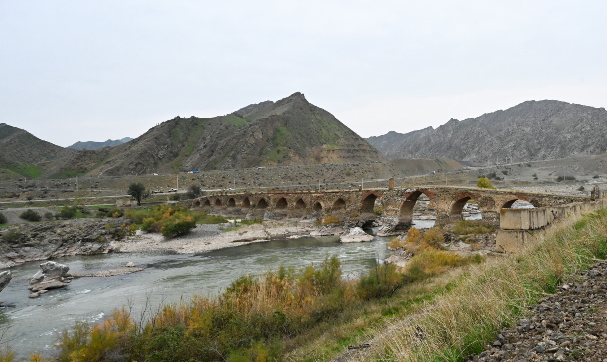
The larger bridge has fifteen spans and stretches about 200 meters across the river, standing 10 meters above the water at its highest point. Its builders used river cobblestone for the breakwaters and arches, topping the parapet with square baked brick. The bridge curves rather than running straight, following the contour of the terrain. Triangular breakwaters on the upstream side deflect the current; semicircular forms on the downstream side complete the hydrodynamic design. The binding mortar was mixed from clay and milk. The smaller bridge, known as "Synyg korpu" -- "broken bridge" -- has eleven spans across 130 meters. It stands taller, reaching 12 meters above the water, and is wider at 6 meters. Its abutments rest on natural rock outcrops, the spans growing longer and taller toward the middle of the river where the current runs deepest. Most scholars date this smaller bridge to the Safavid era, between the 16th and 18th centuries.
Battleground Between Empires
Control of the Khudafarin crossing meant control of the corridor between Iran and the Caucasus. From the rise of Islam through the 19th century, the bridges saw repeated combat. During the Russo-Persian wars, the crossing became a staging area for military operations and was destroyed and rebuilt multiple times. In 1805, the Qajar shah Fath-Ali Shah learned that Ibrahim Khalil Khan, the khan of Karabakh, had defected to the Russians. He sent crown prince Abbas Mirza south to restore order. Russian general Pavel Tsitsianov deployed troops at the base of the Khudafarin bridge to block Abbas Mirza's advance. The Iranian forces broke through, eventually seizing the Shusha fortress. The bridge endured, as it always had, absorbing the violence of competing empires.
Closed at Both Ends
Today both bridges are closed. They sit on the Iran-Azerbaijan border, inaccessible from either side, monuments to a connectivity that geopolitics has severed. The first scholarly description of the fifteen-span bridge appeared in 1938 in "The Art of Iran," edited by A. Pope. Azerbaijani researcher A. Sadikhzade conducted the first on-site measurements in 1963, and a detailed study followed in 1974. The bridges remain objects of national pride for both countries, artifacts of an era when empires built to last and geography dictated the terms of contact between civilizations. The Aras River still flows beneath them, indifferent to the borders drawn above.
From the Air
Located at 39.15°N, 46.94°E on the Aras River at the Iran-Azerbaijan border. The two bridges sit 750 meters apart and are best spotted from lower altitudes following the river valley. The Aras River cuts a visible course through the terrain, marking the international border. The nearest major airport is Tabriz International Airport (OITT), approximately 170 km to the southwest. The Khoda Afarin Dam is nearby. Terrain is rugged and semi-arid, with the river valley providing the clearest visual reference.