Kilauea
In 1990, lava swallowed the town of Kalapana whole. Houses, a church, a store, a community center -- all buried under meters of basalt in a matter of weeks. Residents had time to evacuate, but not to save what they had built. Kilauea did not pause. It has been doing this for at least 200,000 years, and its most recent eruption, which began in December 2024, sent lava fountains over 450 meters into the Hawaiian sky. This is the most active volcano on Earth, and it sits on the southeastern shore of Hawaii's Big Island like a slow-motion engine of creation and destruction.
Born from a Hotspot
Kilauea is the second-youngest product of the Hawaiian hotspot, the stationary plume of magma deep in the Earth's mantle over which the Pacific Plate drifts. The volcano grew above sea level roughly 100,000 years ago and is the current eruptive center of the Hawaiian-Emperor seamount chain that stretches northwest across the Pacific. For decades, geologists dismissed Kilauea as a mere satellite of its massive neighbor Mauna Loa, partly because both volcanoes sometimes erupted simultaneously. That misconception has long been corrected. Kilauea has its own magma plumbing system, its own summit caldera, and two active rift zones -- one stretching 125 kilometers east, the other 35 kilometers west. The eastern rift zone has been the source of some of the volcano's most dramatic and destructive eruptions.
A Lake of Fire and Its Witnesses
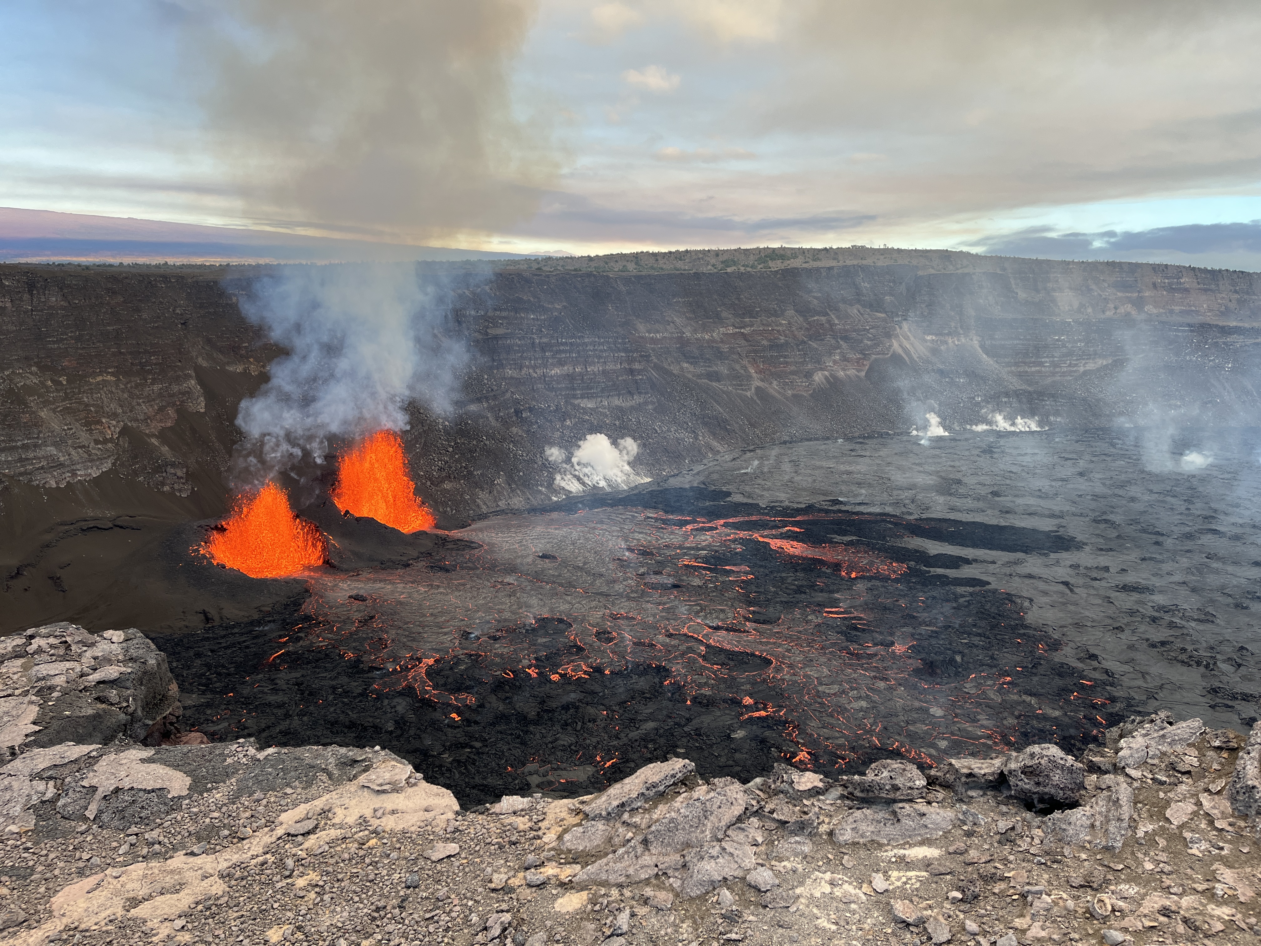
When British missionary William Ellis reached the summit in 1823, he found a vast lake of molten lava churning inside the caldera. Mark Twain visited in 1866 and described the spectacle in terms that read more like revelation than travelogue. For much of the 19th century, the lava lake persisted, drawing scientists and tourists to one of the few places on Earth where you could stand at the edge of liquid rock. The lake drained after earthquakes in 1894, and explosive eruptions in 1924 killed one observer and doubled the width of the Halema'uma'u pit crater. Between 2008 and 2018, the lake returned -- glowing orange at night, visible on webcams worldwide -- before draining again during the catastrophic 2018 eruption that reshaped the entire summit.
The 2018 Reckoning
In May 2018, the volcano's plumbing shifted. Magma drained from the summit lava lake and erupted through two dozen fissures in the lower Puna district, 40 kilometers downslope. Rivers of lava poured into the ocean in three places. Hawaii's largest natural freshwater lake, Green Lake, was boiled away in hours. The communities of Kapoho, Vacationland Hawaii, and most of the Kapoho Beach Lots were buried. The county reported 716 homes destroyed. Meanwhile, at the summit, explosive collapse events sent ash 30,000 feet into the air, damaged the Hawaiian Volcano Observatory, and forced the closure of Hawaii Volcanoes National Park for months. The eruption ended in September 2018, but the landscape it left behind was unrecognizable.
Pele's Domain
Native Hawaiians understood Kilauea long before Western science arrived. The volcano is the home of Pele, goddess of fire, and Hawaiian oral histories record eruptions with striking precision. The name Kilauea itself likely means "spewing" or "much spreading," referring to the lava flows that have shaped the island's southern coast for centuries. Even today, offerings are left at the crater's edge, and the relationship between the Hawaiian people and their volcano runs deeper than tourism or geology. Kilauea is not just a landmark; it is a living presence in Hawaiian culture, a force that gives land and takes it away in the same gesture.
The Volcano That Never Rests
Since the 2018 eruption, Kilauea has continued to erupt in pulses. A water lake formed in the emptied crater in 2019, only to be boiled away by a new eruption in December 2020. Further eruptions followed in 2021, 2022, 2023, and again in December 2024, with episodic lava fountains reaching over 450 meters high. From the air, the summit caldera is a vast wound in the earth, ringed by tropical forest and scarred by fresh flows. Steam rises from cracks in the rock. The glow of lava reflects off clouds at night. Kilauea is not scenery. It is geology happening in real time, and it has been doing so since long before anyone was watching.
From the Air
Kilauea summit caldera at 19.425°N, 155.292°W, elevation approximately 4,091 feet. The caldera is clearly visible from altitude, especially the Halema'uma'u crater which may show active glow or steam. Nearest airport is Hilo International (PHTO), approximately 30 miles northeast. Kona International (PHKO) is on the island's west side. Active volcanic emissions (vog) may reduce visibility, particularly on the leeward side. Caution: volcanic ash and SO2 plumes may be present during active eruptions.