Kingdom of Mapungubwe
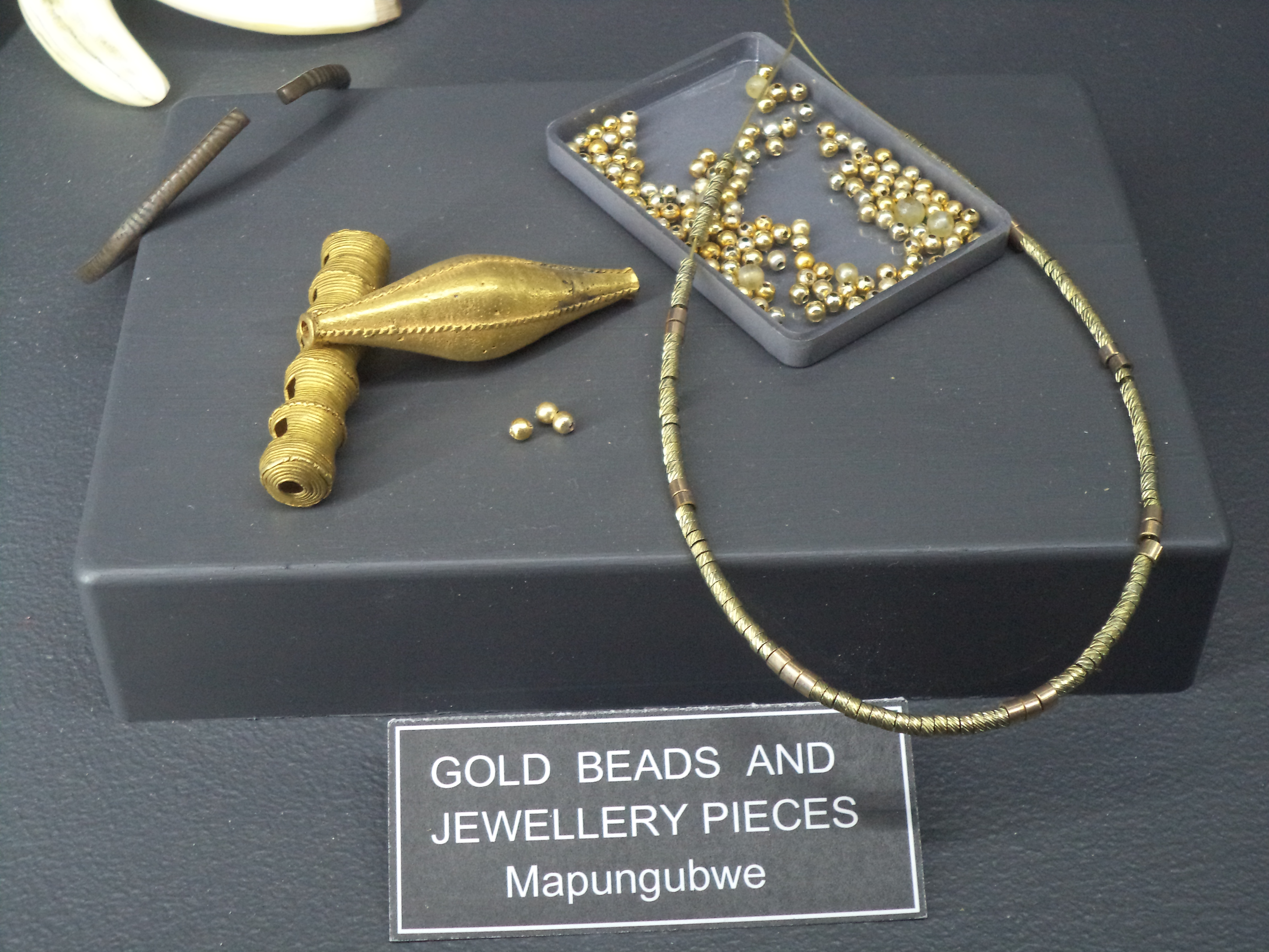
The golden rhinoceros is small enough to hold in one hand -- foil wrapped around a carved wooden core, with tail and ears of fine gold wire. It was buried with its owner on top of Mapungubwe Hill sometime around 1250, placed in a grave alongside gold beads, bracelets, and a gold-plated sceptre. When archaeologists unearthed it in the 1930s, the figurine became proof of something the South African government spent decades trying to deny: that a sophisticated, hierarchical, trade-connected African state had flourished here at the confluence of the Shashe and Limpopo rivers centuries before any European set foot in the region. The Kingdom of Mapungubwe is now recognized as the first state in Southern Africa, and its story is as much about what was hidden as what was built.
A Place of Jackals
Mapungubwe means "a place of many jackals" in various Bantu languages, though the kingdom's original name is lost. The site sits where the Shashe River meets the Limpopo, at the point where modern South Africa, Botswana, and Zimbabwe converge. Today the landscape is dry sandstone hills and Kalahari sand, but around 1000 CE, a wetter climate period transformed the region. Agricultural yields surged. The Leopard's Kopje people moved south to settle the area known as K2, beneath Bambandyanalo Hill, displacing or absorbing the Zhizo people who had been there before them. By 1220, the growing population and increasing social complexity pushed the elite onto the hilltop of Mapungubwe itself -- a physical separation of rulers from ruled that archaeologists consider the hallmark of state formation. The capital reached a population of 5,000, and the kingdom may have covered 30,000 square kilometres.
Gold, Cattle, and the Indian Ocean
Life in Mapungubwe centred on family and farming. Cattle lived in kraals close to houses, a sign of their value. Special sites were designated for initiation ceremonies and social functions. But Mapungubwe was also connected to trade networks that stretched to the Swahili coast and, through it, to the Indian Ocean world. Copper, gold, and tin were not found locally -- the kingdom acquired them through tribute or exchange, leveraging its position at a natural trade crossroads. Gold objects uncovered in elite burials on the royal hill testify to both the wealth and the social stratification of the kingdom. Scholars debate whether long-distance trade created Mapungubwe's class divisions or merely amplified ones rooted in local agriculture and cattle-keeping. What is clear is that by the mid-1200s, this was a place where power, ritual, and commerce intersected in ways that would later echo at Great Zimbabwe to the north.
Rainmakers on the Hill
The king ruled from ritual seclusion on the hilltop, invisible to his subjects below. A brother or designated surrogate handled the daily business of the court, making him the second most powerful person in the kingdom. Rainmaking -- the ritual practice of influencing weather to prevent drought and flood -- was central to the ruler's legitimacy. Earlier communities had turned to San shamans for rain rituals, trusting their connections to the spirits of the land. The San did not share the ancestor beliefs of the Zhizo and other rival groups, which made them politically neutral intermediaries. As Mapungubwe grew more complex, the elite consolidated rainmaking authority on a single hilltop, with the royal family becoming the ritual specialists. It was a political move dressed in spiritual language: whoever controlled the rain controlled the kingdom. Around 1300, the rains may have failed regardless. Trade routes shifted northward, and the population scattered. Their descendants are associated today with the Kalanga and Venda peoples.
The Discovery They Tried to Bury
Local communities had always known about the sacred hill, but the scientific world learned of it in 1933 when a farmer named E.S.J. van Graan and his son brought artefacts to the University of Pretoria. The university, then an exclusively Afrikaner institution, secured rights to the site, and the Hertzog government moved to control access. The problem was straightforward: Mapungubwe's golden artefacts, complex social organization, and trade connections demolished the white supremacist myth that sub-Saharan Africa had produced no civilization worthy of the name. As had happened with Great Zimbabwe, the response was suppression -- hiding findings, restricting access, discrediting interpretations that acknowledged African achievement. It took decades and a change of government for the full story to surface. The Mapungubwe Cultural Landscape was declared a UNESCO World Heritage Site on 3 July 2003, and today South Africa's highest honour, the Order of Mapungubwe, takes its name from the kingdom. The artefacts are housed in the Mapungubwe Museum in Pretoria.
From the Air
Located at 22.19S, 29.24E at the confluence of the Shashe and Limpopo rivers in Limpopo Province, South Africa. From altitude, the confluence of the two rivers marks the tripoint where South Africa, Botswana, and Zimbabwe meet. Mapungubwe Hill, a sandstone formation, is visible as a flat-topped prominence near the confluence. The site lies within Mapungubwe National Park. The nearest significant airport is Polokwane International (FAPP), approximately 250 km to the southeast. The terrain is dry savannah with scattered sandstone formations and the green riparian corridor of the Limpopo visible from altitude.