Kingdom of Nicoya
The name itself tells the story of a kingdom under pressure. Nicoya likely derives from the Nahuatl "Necoc Yaotl" -- "with enemies on both sides" -- an invocation of Tezcatlipoca, the Mesoamerican god of battles. It was a fitting name for the Chorotega civilization that ruled the peninsula and gulf now bearing its title in northwestern Costa Rica, hemmed between the Nicarao people to the north, the Huetar Garabito Empire to the east, and rival groups contesting control of Chira Island in the gulf. For roughly 1,200 years before the Spanish arrived in the sixteenth century, the Kingdom of Nicoya sustained one of the most culturally sophisticated societies on the southern edge of the Mesoamerican world.
Migrants from the Valley of Mexico
The Chorotegas arrived on the Nicoya Peninsula around 800 AD, part of a migration wave from the Valley of Mexico that had passed through Olmec-dominated territories. They settled the Isthmus of Rivas in present-day Nicaragua and spread south into what is now Costa Rica's Guanacaste Province, displacing the existing cultural groups of the Intermediate Area. But the Chorotegas were themselves pushed further when the Nicarao people subsequently entered the Rivas Isthmus, forcing the Chorotegas to expand into the islands and eastern shores of the Gulf of Nicoya. This cascade of displacement had a lasting consequence: it brought the Chorotegas into contact with the indigenous peoples of central and southern Costa Rica, creating a cultural exchange zone where Mesoamerican and South American traditions blended without either fully absorbing the other.
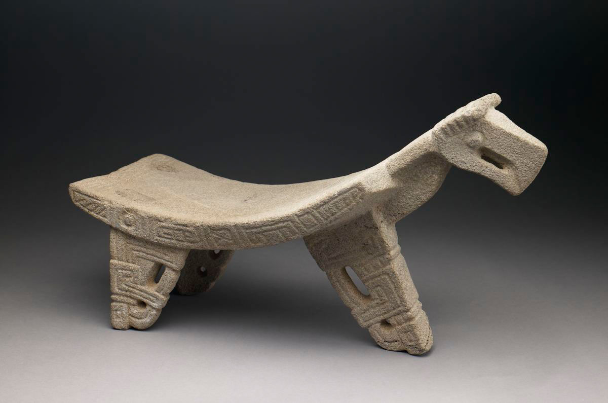
The Greater Nicoya
Archaeologists study the Kingdom of Nicoya within the framework of the Greater Nicoya cultural region, which stretches from the Gulf of Fonseca in Honduras across the entire Pacific coast of Nicaragua to the northern Pacific of Costa Rica. The southern subregion -- encompassing the Nicoya Peninsula, the Tempisque River basin, and the highlands of the Guanacaste and Tilaran mountain ranges -- is where the kingdom concentrated its power. Within this territory, a cultural center flourished for approximately 2,000 years. Archaeological research reveals a society of considerable complexity: specialized agriculture with irrigation systems, organized governance, and artistic traditions that produced three celebrated craft forms -- polychrome ceramics painted in vivid geometric and animal motifs, jewelry fashioned from jade, and intricately carved stone metates used for grinding maize. The ceramic tradition proved so durable that Guanacastecan artisans continue the polychrome style to this day.
A Kingdom with Elections
The Kingdom of Nicoya operated under an elective monarchy -- a system far more sophisticated than the autocratic model Europeans would later impose. The ruler, called mankeme in the Mangue language (the Spanish applied their generic Caribbean term cacique), was appointed by a council of elders known as the monexico. Below the monarch, a system of feudal lords called galpones governed a federation of city-states and tributary villages. When the Spanish arrived in the sixteenth century, they found complex cities, organized governments, and a political structure that distributed power across multiple centers rather than concentrating it in a single capital. The monarch at the time of first European contact bore the name Nicoya -- or Nicoa, or Nicoian, depending on the Spanish rendering -- and as was common practice throughout Costa Rica, the colonizers named the entire territory after its ruler.
Jaguars and Gods
The connection between the Kingdom of Nicoya and Tezcatlipoca ran deeper than a name. Tezcatlipoca, worshiped across the Mesoamerican world by the Nahua peoples, was the god of battles, night, and transformation. One of his manifestations was Tepeyollotl, the jaguar or jaguar-man, and this figure appears repeatedly in Nicoyan art -- on ceramic vessels, in stone carvings, and in the iconography that decorated ceremonial objects. The prevalence of jaguar imagery reflects a society that understood itself as occupying a contested borderland where strength and spiritual protection were inseparable. Gold was considered a symbol of authority rather than currency, and the artisans who worked it created pieces that expressed political power through religious symbolism. The kingdom's artistic output was not decoration; it was a declaration of identity and divine right.
What Endures
The Kingdom of Nicoya did not survive Spanish colonization as a political entity, but its cultural legacy proved more resilient than its borders. The polychrome ceramic tradition has been passed down through generations of Guanacastecan artisans, maintaining techniques and motifs that trace directly to pre-Columbian workshops. The Nicoya Peninsula still bears the name of the last king the Spanish encountered. The archaeological record of the Greater Nicoya -- jade ornaments, painted vessels, carved metates -- fills museums throughout Costa Rica and has informed modern understanding of how Mesoamerican influence reached its southern limits. Perhaps most remarkably, the word Nicoya itself carries forward the memory of a kingdom defined by conflict on all sides, named for a god of battles, and sustained for over a millennium by irrigation, trade, art, and a system of elected governance that would outlast the civilization that created it only in the historical record.
From the Air
Located at 9.92N, 84.15W, corresponding to the city of Nicoya on the Nicoya Peninsula in Guanacaste Province, Costa Rica. The Gulf of Nicoya is visible to the east, and the peninsula extends southward into the Pacific. Daniel Oduber Quiros International Airport (MRLB) in Liberia is approximately 80 km to the northwest. The Tempisque River basin and Guanacaste mountain range are visible from altitude. Best viewed at 5,000-10,000 feet to see the full extent of the peninsula and gulf that defined this kingdom's territory.