Kingdom of Whydah
A slave ship named after this kingdom sank off Cape Cod in 1717, taking pirate captain Samuel Bellamy and his crew to the bottom of the Atlantic. The Whydah Gally was discovered in 1984, the first authenticated Golden Age pirate shipwreck ever found. But the kingdom that gave the vessel its name had already been gone for more than two and a half centuries by then -- conquered by Dahomey in 1727, its royal family scattered to fortified islands offshore. What remains is Ouidah, the Beninese city that still carries the anglicized version of the Xweda people's name, and a history that connects West Africa to Haiti, Brazil, and the coast of Massachusetts in ways that no single shipwreck can contain.
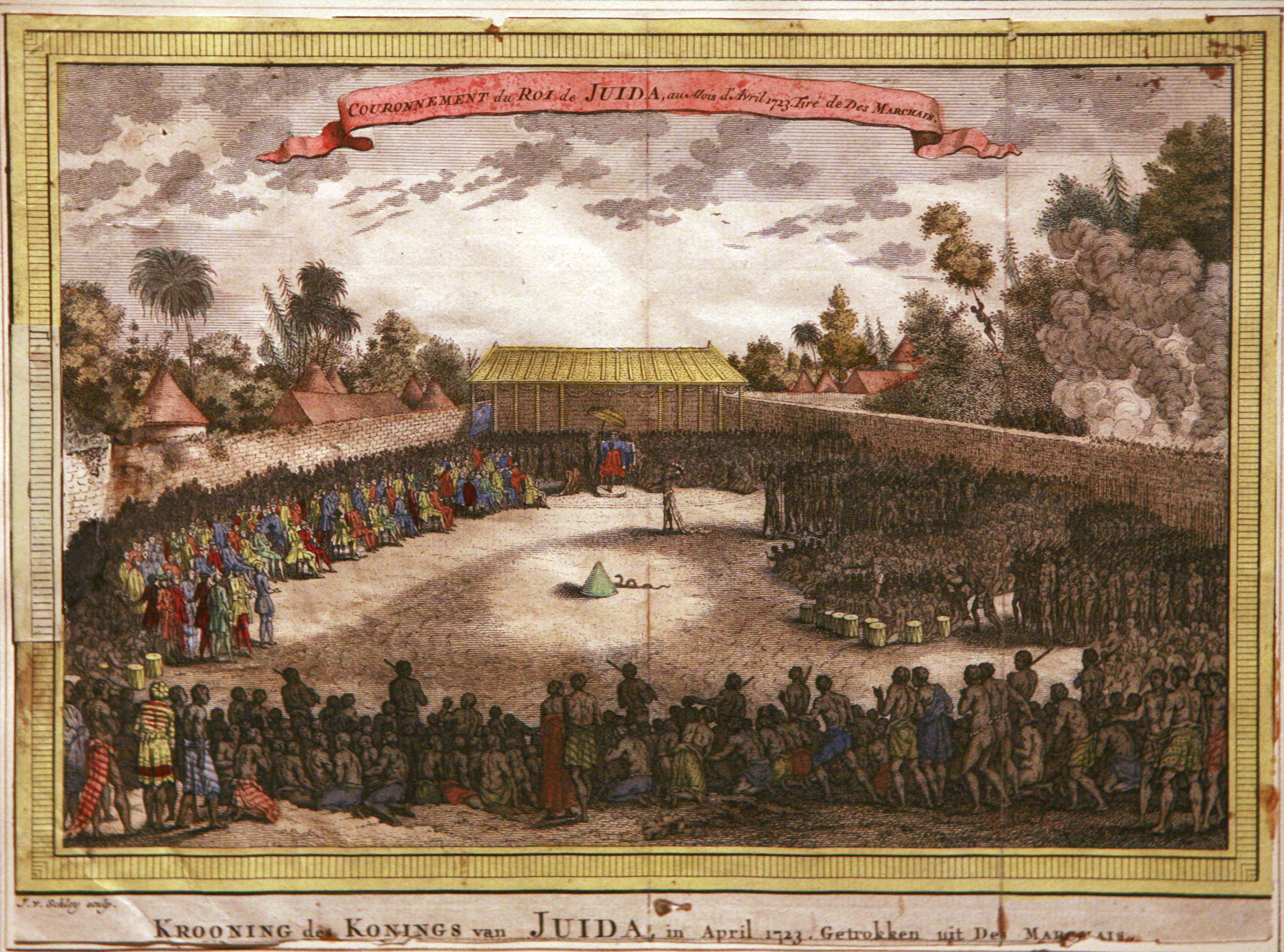
A Kingdom Between the Lagoon and the Sea
The Kingdom of Whydah was centered on Savi, an inland capital, and the port city of Glehue on the coast. According to oral tradition, its first king, Haholo, migrated from Tado and founded Savi; his successor Kpase established Glehue as the kingdom's gateway to the Atlantic. By the 1680s, European sources document the third king, Agbangla, presiding over a state whose coastline stretched roughly ten miles. Under King Haffon, who rose to power in 1708, that coastline expanded to forty miles, reaching twenty-five miles inland. Whydah was not merely a trading post -- it was a sovereign state with a judicial system centered on the ahosu, or king, whose authority was so fundamental that crimes reportedly went unpunished during interregnal periods. Priests and priestesses held positions of high social regard and were immune from capital punishment, reflecting a society where spiritual authority balanced royal power.
Europeans at the Palace Gates
The competition for Whydah's favor was fierce enough to make European trading companies grovel. The French East India Company presented King Haffon with two ships' worth of cargo and an extravagant Louis XIV-style throne. The British Royal African Company countered with a crown. Dutch, British, French, and Portuguese compounds all bordered the walls of Haffon's royal palace in Savi, a physical arrangement that said everything about who held power. The Europeans' coastal forts near Glewe, built of mud walls and stocked with enslaved people and trade goods, looked imposing but were functionally vulnerable -- too far inland for naval guns to reach, too weak to withstand any serious local assault. The Europeans depended on the king for protection and on local people for food and firewood. For a time, Whydah dictated the terms.
The Human Cost of Commerce
More than one million enslaved Africans were shipped from Whydah's coast to the United States, the Caribbean, and Brazil before the trade finally closed in the 1860s. The scale of that number resists comprehension -- a million individual lives uprooted, families destroyed, futures erased. The kingdom participated in this commerce as both broker and beneficiary, capturing and purchasing people from the interior to sell to European traders at the coastal forts. This was the economic engine that drew four European nations to crowd their compounds around a single king's palace walls. The Whydah Gally itself began as a slave ship before Samuel Bellamy captured it and turned it to piracy in 1717, a trajectory that links the kingdom's commerce to both the Middle Passage and the golden age of Atlantic piracy.
Conquered but Not Erased
In 1727, King Agaja of Dahomey conquered Whydah, deposing King Haffon and absorbing the kingdom. But Whydah did not simply vanish. Its people fortified two offshore islands with mounted artillery, establishing a refugee dynasty that harassed Dahomey from the water for decades. The Whydah navy deployed boats to raid the mainland and retreat to island strongholds, exploiting the one advantage Dahomey could not easily counter. It took until 1774 for Dahomey to find a solution -- building a causeway to reach the islands. Even after absorption, Whydah's conquest transformed Dahomey into a regional power, though Dahomey itself soon faced pressure from the Oyo Empire, becoming a tributary state after warfare lasting from 1728 to 1740. Power on this coast shifted constantly, each kingdom rising on the resources extracted from its neighbors and, ultimately, from the people it sold across the ocean.
Names That Travel
The name Whydah -- an anglicized form of Xweda, from the language and people of this stretch of coast -- has traveled further than any of its kings could have imagined. A family of brood-parasitic birds native to Africa carries the name, the whydah birds. A pirate ship carries it to the floor of the Atlantic. The city of Ouidah carries it into the present, where Vodun ceremonies and the annual Voodoo Festival draw visitors to a place whose identity was forged in the convergence of African spiritual traditions, European commercial ambition, and the transatlantic slave trade. The Ouidah Museum of History preserves the story of the Xweda people, ensuring that the kingdom's legacy is told not just through European accounts of trade and conquest, but through the voices of those who lived there first.
From the Air
Located at 6.42N, 2.10E on the coast of southern Benin. The modern city of Ouidah marks the kingdom's former territory. From altitude, the narrow strip of land between the Atlantic Ocean and the coastal lagoons defines the geography that shaped Whydah's power. Cadjehoun Airport (DBBB) in Cotonou is approximately 40 km to the east. Best viewed at 3,000-5,000 ft to appreciate the coastal layout and lagoon system.