Kintampo Waterfalls
The sound arrives before the sight. Walking north from the town of Kintampo through increasingly thick forest, you hear the Pumpum River before you see what it does -- a cascade in three stages that drops roughly 70 metres through a crack in the Ghanaian interior, water plunging off laterite ledges into pools cold enough to shock. During the colonial era, the British called it Sanders Falls. The name did not stick. The water kept falling regardless of what anyone chose to call it, fed by a river that rises at Pumpumatifi and eventually feeds the Black Volta on its long arc through West Africa.
A Staircase into the Earth
Kintampo Waterfalls unfolds in three distinct drops. The first two stages are gentle -- the path is level, the forest canopy thick overhead, the air noticeably cooler than the surrounding savanna. Then comes the descent: 173 stairs down along a rock face slick with mist, the roar growing louder with each step. At the base, the main drop sends water plummeting roughly 25 metres from a ledge above, crashing into a pool ringed with mossy boulders. The climb back up requires 151 stairs, a number that every visitor remembers in their legs. The forest surrounding the falls shelters bird species drawn to the microclimate the water creates, and the pools at the base are deep enough for swimming -- a fact that has drawn visitors from across Ghana since the falls were designated a tourist site in 1992.
The Day the Tree Fell
On March 20, 2017, a storm tore through the forest above the falls. A large tree, its roots loosened by the saturated soil, toppled onto a crowd of visitors gathered near the water. Twenty people died — eighteen at the scene and two more at the hospital. Twenty-two others were pulled from the debris by police and rescue teams. The Ghanaian Ministry of Tourism, Arts and Culture closed Kintampo immediately, launching a security and safety assessment of the entire site. For two years, the falls stood silent -- no tourists, no swimmers, no laughter echoing off the rock walls. The tragedy forced a reckoning with what it meant to make a natural site accessible without making it dangerous.
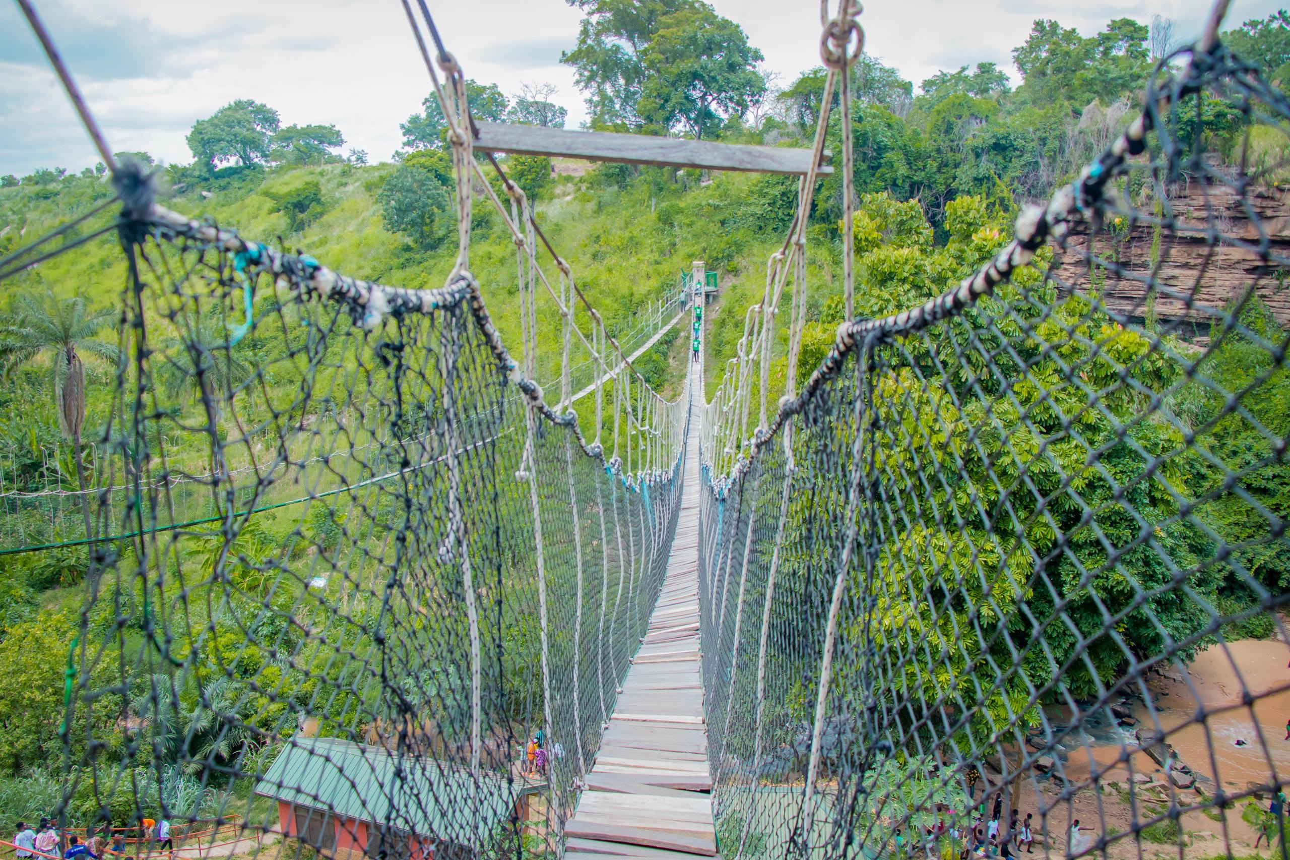
A Walk Above the Canopy
When Kintampo reopened in 2019, the site had been transformed. Two canopy walkways now stretch above the forest -- one spanning 90 metres, the other 80 metres -- each engineered to support twenty people at a time. From these elevated platforms, visitors look down into the tree cover that once hid the danger below, seeing the falls from an aerial perspective that the old ground-level trail never offered. A reception center, improved staircases with railings, and a proper car park replaced the informal access of earlier years. The changes worked: over 23,000 people visited in 2019 alone, a surge that made Kintampo one of the most visited natural sites in the Bono East Region. The falls had become, in a grim irony, a better destination because of the disaster that closed them.
Water, Trade, and the Interior
The Pumpum River that feeds Kintampo Waterfalls is a tributary of the Black Volta, one of the great waterways that shaped trade and settlement across the interior of what was once the Gold Coast. Kintampo itself sits near the geographic center of modern Ghana, a crossroads town where the forested south gives way to the drier northern savanna. The falls mark a transition zone -- below the canopy, the air is wet and green, thick with ferns and the smell of damp earth. A few kilometres away, the landscape opens into the grasslands that stretch toward Tamale and the Sahel. This ecological boundary made the area a meeting point for cultures moving between forest and savanna for centuries, and the river provided fresh water to generations of travelers long before anyone thought to call its most dramatic feature a tourist attraction.
From the Air
Located at 8.09N, 1.70W, about 4 km north of Kintampo town in Ghana's Bono East Region. The falls are embedded in thick forest cover and are not easily visible from high altitude, but the Pumpum River corridor and the clearing around the visitor facilities can be spotted. Nearest significant airport is Sunyani (DGSN), approximately 130 km to the south. Tamale Airport (DGLE) lies to the north. Best viewed at lower altitudes in clear conditions when the river corridor through the forest canopy becomes apparent.