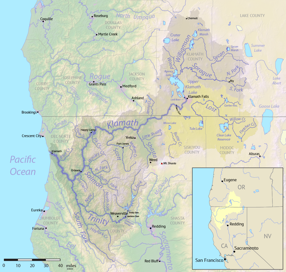
Klamath Basin
Eleven thousand years ago, a freshwater sea covered this high desert. Lake Modoc stretched across the entire Upper Klamath Basin, a body of water three times larger than the Salton Sea in southern California. When the ice age ended, the great lake drained away, leaving behind a labyrinth of rivers, marshes, and smaller lakes that still pulse with life. Today, up to 3.7 million birds migrate through the basin's remaining wetlands each year, following an ancient route that predates human memory. The Klamath Basin spans two states, seven counties, and contains one of the most contested water systems in the American West.
Water Writes the Story
The Klamath River drains 9.4 million acres of Oregon and California, thirty-five percent north of the state line and sixty-five percent to the south. The watershed defies simple description: semi-desert at lower elevations in Oregon, dry alpine in the upper reaches, temperate rainforest in California's western portion. Upper Klamath Lake, the basin's centerpiece, encompasses just 0.6 percent of the total watershed today. But historically, Lower Klamath Lake and Tule Lake formed one interconnected freshwater marsh more than twice the present lake's size. In wet years, all three lakes would merge into a single vast body of water, a ghost of that ancient inland sea. Artesian wells still discharge groundwater into Upper Klamath Lake, essential for maintaining river flow through the year.
Layers of Ancient Rock
Beneath the basin lies a geological puzzle box. The Upper Klamath Watershed sits between the Cascade Range and the Basin and Range Province, its bedrock a stack of volcanic deposits, ejecta, and fluviolacustrine sediments. Three distinct hydrologic layers control how water moves underground: highly permeable basalt serves as the principal aquifer, the Yonna Formation of tuff and volcanic ash acts as a groundwater cap, and more recent eruptive deposits overlie everything. Little water penetrates down to the deep aquifers. Snowmelt recharges the system, filtered through faults and fractures. The geology explains why water has always been precious here and why fights over it never end.
The Human Equation
About 114,000 people lived within the Klamath watershed as of the 2000 census, concentrated around Klamath Falls, Oregon (population 19,462) and Yreka, California (7,290). Land ownership tells a story of competing claims: 90,000 acres under tribal reservation control, 6.2 million acres managed by federal agencies including the Bureau of Land Management and National Park Service, and 3.7 million acres in private hands. Of that private land, 557,000 acres are farmed, eighty percent of it irrigated. Nearly half the irrigated acreage depends on water from the Bureau of Reclamation's Klamath Project, a system that has pitted farmers against tribes, fishermen against ranchers, and state against state for generations.
Rivers That Define a Region
The Williamson and Sprague rivers flow from the north, draining 19.4 percent of the watershed. The Lost River basin to the southeast is the largest subwatershed by area, claiming another 19.1 percent. The Shasta, Scott, and Salmon rivers drain the western slopes. The Trinity River, California's largest Klamath tributary, feeds a reservoir bigger than all four mainstem Klamath dams combined. Each river carries its own character and controversy. Congressional hearings continue to debate the basin's future, including the Klamath Basin Water Recovery and Economic Restoration Act. The names change, the water wars continue, and 3.7 million birds still arrive each year, indifferent to human boundaries.
From the Air
The Klamath Basin centers around 42.0°N, 122.0°W, spanning southern Oregon and northern California. Upper Klamath Lake is the primary visual reference, with the Cascade Range to the west and the Modoc Plateau to the east. Major airports include Klamath Falls Airport (LMT) in Oregon. The terrain varies from high desert to mountain forest. Multiple reservoirs visible along the main Klamath River channel. Weather can vary dramatically between the semi-arid eastern basin and the wetter western reaches.