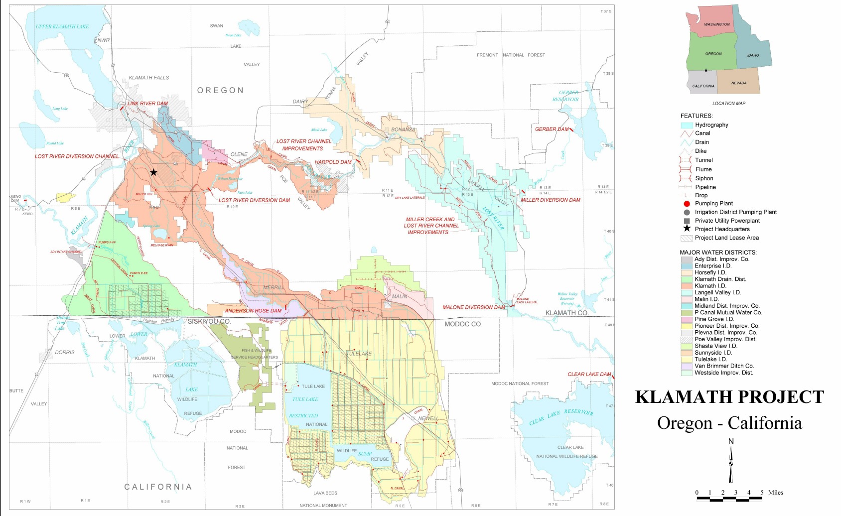
Klamath Project
Every year, millions of migratory birds descend on the Klamath Basin along the Pacific Flyway, unaware they are landing in a battlefield. Below their wings stretches a patchwork of reservoirs, canals, and farmland that was once an immense network of marshes and shallow lakes. The Klamath Project - one of the first undertakings of what would become the Bureau of Reclamation - transformed this landscape beginning in 1906. Today it grows barley, alfalfa, potatoes, and wheat. It also grows conflict: a century-long struggle over water that has pitted farmers against fishermen, endangered species against economic necessity, and Indigenous rights against irrigation contracts.
Draining a World
Construction began in 1906 with the main 'A' Canal, and water first flowed to farmers on May 22, 1907. What followed was an engineering campaign to remake the land itself. The Clear Lake Dam went up in 1910, the Lost River Diversion Dam in 1912. By 1925, seven dams had been completed across tributaries of the Klamath River. Canals, laterals, and diversion channels now stretch across the basin, fed by 28 pumping stations with a combined output of over 1,937 cubic feet per second. Lower Klamath Lake, once a vast shallow marsh straddling the Oregon-California border, was drained to create farmland. Tule Lake shrank as its waters were diverted to the Klamath River. The Lost River, which once drained into the endorheic Tule Lake with nowhere to go, now feeds the Klamath system.
The Link River Connection
The Link River Dam, completed in 1921, sits at the heart of a complicated arrangement. A contract signed on February 24, 1917, between the California-Oregon Power Company and the United States authorized the company to build the dam for both irrigation and power generation. Today this dam belongs to two systems: the government-owned Klamath Project that irrigates farms, and the for-profit Klamath River Hydroelectric Project operated by PacifiCorp. Upper Klamath Lake and the Klamath River serve as the project's main water sources, filling reservoirs from spring runoff that peaks in March and April - water that once would have flooded the historic marshes now covered by fields of grain.
The Fish Wars
In 1988, two species of sucker fish native to Upper Klamath Lake were listed as endangered: the Lost River Sucker and the Shortnose Sucker. Concerns for threatened Coho salmon runs added to the pressure. On April 6, 2001, a court order cut off irrigation water to Klamath Project farmers to maintain mandated river levels for the fish. Farmers protested. Citizens rallied. The decision was reversed the following year. Then came catastrophe: in 2002, low water and high temperatures in the lower Klamath during salmon migration created conditions for a gill rot disease that killed massive numbers of fish. Studies blamed drought conditions and low flow from the entire drainage system. A 2002 National Research Council report found the 2001 water cutoff was not scientifically justified, and that the 2002 fish kill stemmed from natural factors.
Troubled Waters
The conflict inspired books - 'Salmon is Everything' detailed the human cost of the fish kills, while 'River of Renewal: Myth and History in the Klamath Basin' explored the deeper tensions between ecology and economy. In 2010, the Klamath Basin Restoration Agreement attempted to broker peace. The Governors of California and Oregon signed, as did the Chairman of the Klamath Tribes. But antagonism persists. The Bureau of Reclamation must balance water for farms against water for endangered suckers in the lake and threatened salmon in the river. The wildlife refuges that the project also supplies - Tule Lake National Wildlife Refuge and Lower Klamath National Wildlife Refuge - add another voice to the chorus of competing needs.
Land of Contradictions
From the air, the Klamath Project looks like order imposed on chaos: geometric fields and straight canals carved into volcanic soil, reservoirs glinting in the high desert sun. Yet this engineered landscape remains wild in ways its builders never intended. The Pacific Flyway still brings clouds of waterfowl each year to the Klamath Basin National Wildlife Refuges Complex. Farmers still plant their crops each spring, hoping for water. Salmon still struggle upstream to spawn. The Klamath Tribes still assert their treaty rights. And the water - never enough, always contested - flows through a system of dams and canals built to solve problems that multiply faster than they can be contained.
From the Air
Located at 42.1N, 121.6W in the Klamath Basin straddling the Oregon-California border. The project's infrastructure is visible from altitude: Upper Klamath Lake is the large body of water to the north, with the network of canals and reduced Tule Lake to the south. Look for the geometric patterns of irrigated farmland contrasting with the darker volcanic terrain of nearby Lava Beds National Monument. Nearest airports: Klamath Falls Airport (KLMT) is the primary facility in the area. Tulelake Municipal (O81) provides access to the southern portion. Expect variable weather; the high desert can produce strong thermal activity in summer.