Koke'e State Park
The clouds do not so much roll in as live here. At 3,200 feet on Kauai's northwestern plateau, Koke'e State Park occupies a world that most visitors to Hawaii never imagine exists: cool, damp, tangled with ancient forest, and wrapped in the kind of quiet that only 70 inches of annual rain can produce. This is not the Hawaii of postcards. The dominant trees are koa and ohia lehua, species that evolved in isolation over millions of years, and the birdsong filtering through their canopy belongs to species found nowhere else on Earth. The park's 4,345 acres sit just above Waimea Canyon, and at the end of the road, the land simply drops away into the Kalalau Valley, a chasm of green cliffs that once sheltered a thriving Hawaiian community.
A Forest Between Worlds
Koke'e is a place defined by elevation and moisture. The plateau sits between 3,200 and 4,000 feet, high enough for infrequent frost but low enough for lush growth. Botanists classify much of it as montane mesic forest, a habitat receiving between 50 and 100 inches of rain per year, with soil that stays moist through the drier summer months. Koa trees, with their distinctive sickle-shaped leaves, tower overhead, while ohia lehua trees anchor the understory with bursts of red blossoms that Hawaiian tradition associates with the volcano goddess Pele. Walk the Alakai Swamp Trail, a 3.5-mile boardwalk covered in chicken wire for traction against the perpetual mud, and you enter one of the highest-elevation bogs in the world. The Pihea Trail traces the rim of the Kalalau Valley through dripping ohia wet forest, offering birdwatchers their best chance at spotting species like the apapane and the iiwi, crimson-feathered honeycreepers that have retreated to these upper elevations as mosquito-borne disease pushed them from the lowlands.
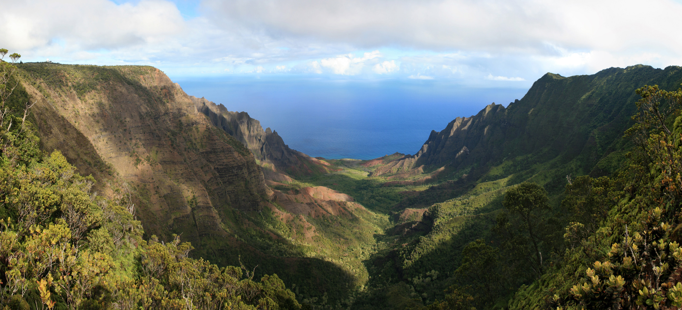
The Valley at the End of the Road
State Road 550 climbs eighteen miles from the coast through Waimea Canyon before terminating at a lookout that makes most visitors catch their breath. Below, the Kalalau Valley opens like a cathedral carved by water and time, its walls plunging more than 2,000 feet to a flat, green floor. For centuries, Native Hawaiians cultivated taro in terraced fields on that valley floor, sustaining a population of thousands in one of the most isolated communities in the archipelago. The valley's remoteness eventually became its defining feature. Jack London visited Kauai in the early 1900s and set his short story "Koolau the Leper" against these cliffs, drawing on the true account of a man with leprosy who fled into the Kalalau Valley rather than submit to forced exile on Molokai. The story is one of defiance and dignity, and the valley's towering walls give it the weight of a natural fortress.
Trails That Teach
Koke'e's trail network spans more than 45 miles, and nearly every path doubles as a lesson in ecology. The Berry Flat Trail passes through groves of Coast Redwood and Japanese sugi planted decades ago, living evidence of forestry experiments that now grow alongside native species in an uneasy coexistence. The Canyon Trail follows the rim of Waimea Canyon for 1.8 miles, crossing Koke'e Stream and offering views into the red-walled gorge below. Feral goats, visible from the Cliff Trail spur, pick their way along canyon walls that glow in shades of rust and ochre. For those willing to descend, the Kukui Trail drops 2,000 feet in 2.5 miles into the canyon itself. Recovery from Hurricane Iwa, which struck Kauai in 1982, remains visible along the Halemanu-Koke'e Trail, where the forest is transitioning from damaged scrub back toward mature koa canopy. The Iliau Nature Loop, an easy quarter-mile walk, introduces visitors to the iliau plant, a relative of the Maui silversword found only on Kauai.
Queen Emma's Legacy
Each October, the park hosts the Emalani Festival honoring Queen Emma, who made a rugged journey to these uplands in 1871. Emma was the widow of King Kamehameha IV and a woman of considerable political ambition; her trek to Koke'e was both a personal pilgrimage and a statement of connection to the land. The festival reenacts her arrival with Hawaiian music, hula, and lei-making, drawing visitors who might otherwise never venture this far from the coast. The Koke'e Museum, housed at the fifteen-mile marker on State Road 550, focuses on the park's weather, vegetation, and birdlife, and a nearby lodge serves food and rents cabins. Despite its relative accessibility by road, Koke'e retains a feeling of genuine remoteness. The clouds close in quickly, the temperature drops, and the forest hums with a life that predates human arrival by millions of years.
From the Air
Located at 22.13N, 159.66W on Kauai's northwest interior plateau. From the air, look for the sharp transition between the red walls of Waimea Canyon and the dense green canopy of the park. The Kalalau Valley lookout is visible where the road terminates. Nearest airports: Lihue Airport (PHLI) approximately 20 miles southeast. Recommended viewing altitude: 3,000-5,000 feet AGL for canyon and valley perspective. Cloud cover is common; early morning offers the best visibility.