Kokopo
On 19 September 1994, when the twin volcanoes Tavurvur and Vulcan erupted together at the northern end of the Gazelle Peninsula and buried the old capital of Rabaul in volcanic ash, the government of East New Britain Province needed somewhere to go. They chose a sleepy coastal town twenty kilometres down the road, a place that had been busy exactly once before, in the era of Otto von Bismarck, and had been quietly shrinking ever since. Almost overnight Kokopo's population jumped sixfold, from about 3,150 residents in 1990 to 20,262 by 2000. The old German capital that Rabaul had replaced in 1910 now, in an accidental kind of justice, replaced Rabaul.
Named for a Chancellor's Son
Before it was Kokopo, this place was Herbertshohe, meaning Herbert's Heights in German. The man it was named for was Herbert von Bismarck, eldest son of the Iron Chancellor Otto von Bismarck, who had shepherded the unification of Germany a generation earlier. Germany planted its flag over this coast on 3 November 1884, and Herbertshohe became the first capital of the new colony of German New Guinea. The choice said something about German colonial ambitions in the Pacific, grand enough to name a capital after the chancellor's heir, modest enough to settle for a hillside above a coconut plantation. The capital would move to Rabaul in 1910, leaving Herbertshohe as a district centre. Australian forces landed here at dawn on 11 September 1914 and raised the Union Jack at 07:00 without a shot fired. The German name faded; the Tolai people's name, Kokopo, returned.
The Day Rabaul Ended
The story of modern Kokopo really begins with what happened to its rival. For most of the twentieth century Rabaul was the important town on New Britain, its harbour among the finest in the Pacific, its population by 1994 over seventeen thousand. Then two volcanoes went off together. Tavurvur on the eastern side of the caldera and Vulcan on the western side erupted simultaneously on 19 September 1994. Ash fell for days, sometimes measured in feet rather than inches. Roofs collapsed under the weight. The airport runway was buried. By the time the eruption ended, Rabaul as an administrative centre was finished. Government offices, businesses, and most residents relocated down the coast to Kokopo. Rabaul today has something like four thousand people living in its still-active shadow. Tavurvur continues to steam. In 2014 it erupted again, spectacular and terrifying and mercifully brief.
A Coast That Will Not Sit Still
The Gazelle Peninsula is volcanic country, and its ground does not rest. On 29 March 2015, a magnitude 7.5 earthquake struck offshore near Kokopo, at that time the largest earthquake of the year, and prompted a tsunami warning that rippled out across the Pacific. The wave, when it came, was small. A month later the Nepal earthquake of April 2015 measured magnitude 7.8 and overtook Kokopo's place in the geological record books. For residents of East New Britain, this is the rhythm of life. The province sits on the Pacific Ring of Fire, where the Pacific plate grinds against the Australian plate and the result is mountains that sometimes explode. Rabaul's old caldera, now partly filled with Simpson Harbour, is itself the ruin of an eruption so massive that the harbour it created is the top of a drowned volcano.
The Dolphins and the Deep Water
Kokopo's beachfront runs along water where spinner dolphins still gather in morning pods, leaping clear of the surface in the tight spinning motions that give them their name. In 2015, researchers proposed a study and conservation plan for this population, concerned that deepening the harbour for larger container ships might push them elsewhere. The development pressure is real. As Papua New Guinea's economy slowly integrates with Asian shipping routes, ports along this coast have become strategic, and a provincial capital with a working harbour is a prize. Tokua Airport just east of town, often still called Rabaul Airport despite the name change, is one of the country's busier domestic terminals. The PNG Hunters rugby league team, founded in 2013, plays its home matches at Kalabond Oval in Kokopo in black, red, and gold, having earned a spot in Queensland's Intrust Super Cup competition.
Living in Someone Else's Disaster
Kokopo is a town that grew by inheriting the tragedy of another. Its jump from three thousand to twenty thousand people in a decade was not the result of a boom but of a displacement. Some of the families now living in Kokopo remember walking out of Rabaul in 1994, carrying what they could, watching the sky turn grey and their rooftops sag. For others, born since, Kokopo is simply home. The provincial government buildings, the cathedral, the market, the university campus, all the accoutrements of a capital, were built or expanded here on the ruins of someone else's misfortune. The climate does not vary much. Köppen classifies it Af, tropical rainforest, hot and wet year-round. The palms look much as they did when Herbert von Bismarck's name was on the place. The volcanoes on the horizon, however, are a reminder that this coast does not make long-term plans. It makes the next one.
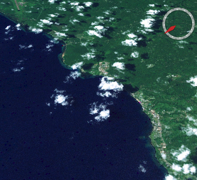
From the Air
Kokopo lies at 4.35S, 152.27E on the Gazelle Peninsula of New Britain, about 20 km southeast of Rabaul. Tokua Airport (AYTK, ICAO code) is the provincial hub, runway length 1,838 m, suitable for turboprops and smaller jets. Cruise at 2,000-5,000 ft for the best view of the twin volcanoes Tavurvur and Vulcan to the northwest, Simpson Harbour's drowned caldera, and the coastline to the south. Afternoon convective weather is common. Volcanic ash advisories periodically affect approaches; check SIGMET for Tavurvur before flight planning.