Komine Castle: The Fortress That Changed Hands Twenty-One Times
Twenty-one lords ruled from these walls. Seven different samurai clans held the castle over two and a half centuries, each inheriting a fortress built on a narrow hilltop above the Abukuma River, each adding their own stone, their own ambitions. Komine Castle in Shirakawa sat at the most strategic chokepoint in northeastern Japan -- the point where the great Oshu Kaido highway crossed from the Kanto plains into the Tohoku wilderness. Whoever controlled this hilltop controlled the north. That made Shirakawa a prize worth fighting over, and the castle's story is one of constant reinvention: built in 1340 as an earthen palisade, rebuilt with stone walls under the Gamo clan, expanded into a proper fortified domain by Niwa Nagashige in the 1620s, and finally destroyed in the fires of the Boshin War in 1868. Today it stands again -- reconstructed, earthquake-scarred, and listed among the 100 Fine Castles of Japan.
The Gateway to the North
The geography explains everything. Komine Castle occupies a long, narrow ridge stretching 500 meters east to west above a bend in the Abukuma River. The river itself served as a natural moat on one side, while the castle's builders reinforced the other approaches with tall stone walls, earthen ramparts, and wide water-filled ditches. The inner bailey perched at the ridge's end, separated into two layered enclosures, with a three-story yagura tower at its northeastern corner serving in place of a true tenshu keep. Below, a secondary enclosure of roughly 200 by 100 meters housed the lord's residence. The ancient Shirakawa Barrier -- a checkpoint that had regulated travel between north and south since the Nara period -- once stood nearby. Control of this corridor along the Oshu Kaido meant control of commerce, communication, and military movement between the Kanto heartland and the domains of the far north.
Seven Clans, Seven Fortunes
Yuki Chikatomo raised the first fortifications here in 1340 -- simple earthen walls and wooden palisades crowning the hilltop. The Yuki held on for two and a half centuries before Toyotomi Hideyoshi stripped them of their lands in 1590. The Gamo clan modernized the site with stone walls, but the real transformation came in 1627 when Niwa Nagashige arrived as the first lord of the newly created Shirakawa Domain, worth 100,000 koku of rice revenue. Between 1628 and 1632, Nagashige rebuilt Komine Castle from the ground up. What followed was a parade of power: the Niwa gave way to the Sakaibara, then the Honda, then three separate branches of the Matsudaira clan, and finally the Abe. The most celebrated of all these rulers was Matsudaira Sadanobu, who governed from 1783 and became famous across Japan for his austere fiscal reforms, encouraging academics and martial arts while demanding frugality from his samurai.
The Boshin War Comes to Shirakawa
In 1868, Japan tore itself apart. Komine Castle became a stronghold of the Ouetsu Reppan Domei, an alliance of northern domains loyal to the Tokugawa shogunate. When the pro-imperial forces of the Satcho Alliance advanced northward during the Battle of Aizu, Shirakawa stood in their path. The castle had been designed to repel attacks from the north -- the traditional direction of threat -- which left its southern approaches more lightly defended. The imperial army, though outnumbered, wielded superior Western artillery. The castle fell on May 1, 1868. Fire consumed nearly every structure within the walls. What the battle spared, the new Meiji government demolished after abolishing the feudal domain system. The hilltop that had sheltered twenty-one successive lords was scraped clean and converted into a public park, its centuries of military architecture reduced to foundation stones and empty moats.
Rebuilding from Photographs
Komine Castle's resurrection began in 1991 with the reconstruction of its three-story tenshu on the original foundations. A gate followed in 1994. But the 2011 Tohoku earthquake delivered a cruel irony. An original section of the castle's earth-and-stone walls had collapsed in the 1970s due to rain damage, and the local government repaired it with concrete. When the earthquake struck, the concrete section shattered completely -- its rigid modern material unable to flex with the tremors the way the original loose stonework had done for centuries. The rest of the castle also sustained significant damage, with cracked stone walls and shifted foundations across the site. Faced with the task of restoring walls they had unknowingly destroyed the records of, the Japanese government turned to Shirakawa's citizens, asking for old photographs of the original walls. Detailed drawings left behind by Matsudaira Sadanobu also proved essential. The castle continues its slow restoration today, its story still unfinished, still adapting to whatever comes next.
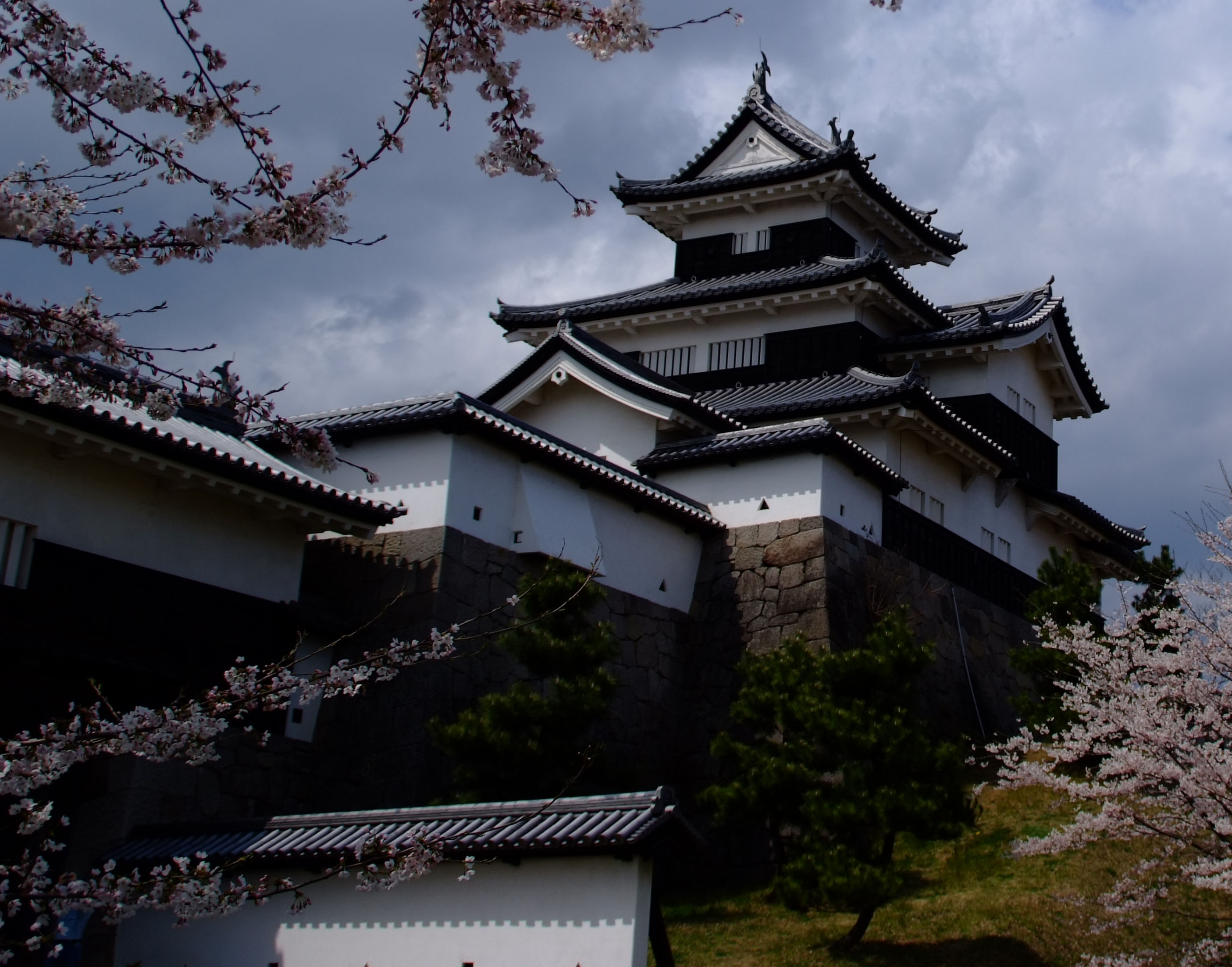
Cherry Blossoms on the Battlements
Each spring, Komine Castle transforms. The stone walls and reconstructed tenshu disappear behind cascades of pale pink sakura, and the former fortress grounds fill with families spreading picnic blankets beneath the blossoms. The castle is recognized as one of the region's finest hanami viewing spots, the white tower framed against clouds of cherry flowers with the Abukuma River curving below. It is a scene that collapses seven centuries of conflict into something serene -- a warlord's stronghold become a public garden, its moats reflecting petals instead of siege ladders. Designated a National Historic Site in 2007 and counted among the 100 Fine Castles of Japan, Komine Castle today offers visitors both a lesson in the layered history of Japan's feudal north and one of Fukushima Prefecture's most beautiful spring landscapes.
From the Air
Located at 37.13°N, 140.21°E in the city of Shirakawa, southern Fukushima Prefecture. The castle sits on a narrow east-west ridge above a bend in the Abukuma River, with the reconstructed three-story tenshu visible as a white structure on the hilltop. Best viewed at 2,000-3,000 feet AGL from the south or east, where the river bend and castle ridge are most distinct. The Oshu Kaido highway corridor runs north-south through the area. Fukushima Airport (RJSF) lies approximately 30 nautical miles to the north. The Nasu volcanic range is visible to the southwest. Shirakawa sits in a valley between mountain ranges, so mountain weather and wind shear are possible at lower altitudes.