Korouoma
Every winter, the streams trickling down Korouoma's cliff faces freeze into enormous pillars and curtains of ice, transforming a remote canyon in Finnish Lapland into the country's premier ice climbing destination. But the frozen waterfalls are only the most dramatic feature of a landscape that has been shaped over millennia. Korouoma is a fracture valley roughly 30 kilometers long, a few hundred meters wide, and up to 130 meters deep, carved into the terrain near the municipality of Posio. At its floor, the Korojoki River meanders northwest toward the Kemijoki, lined by flood meadows and herb-rich forests that feel wildly out of place this far above the Arctic Circle.
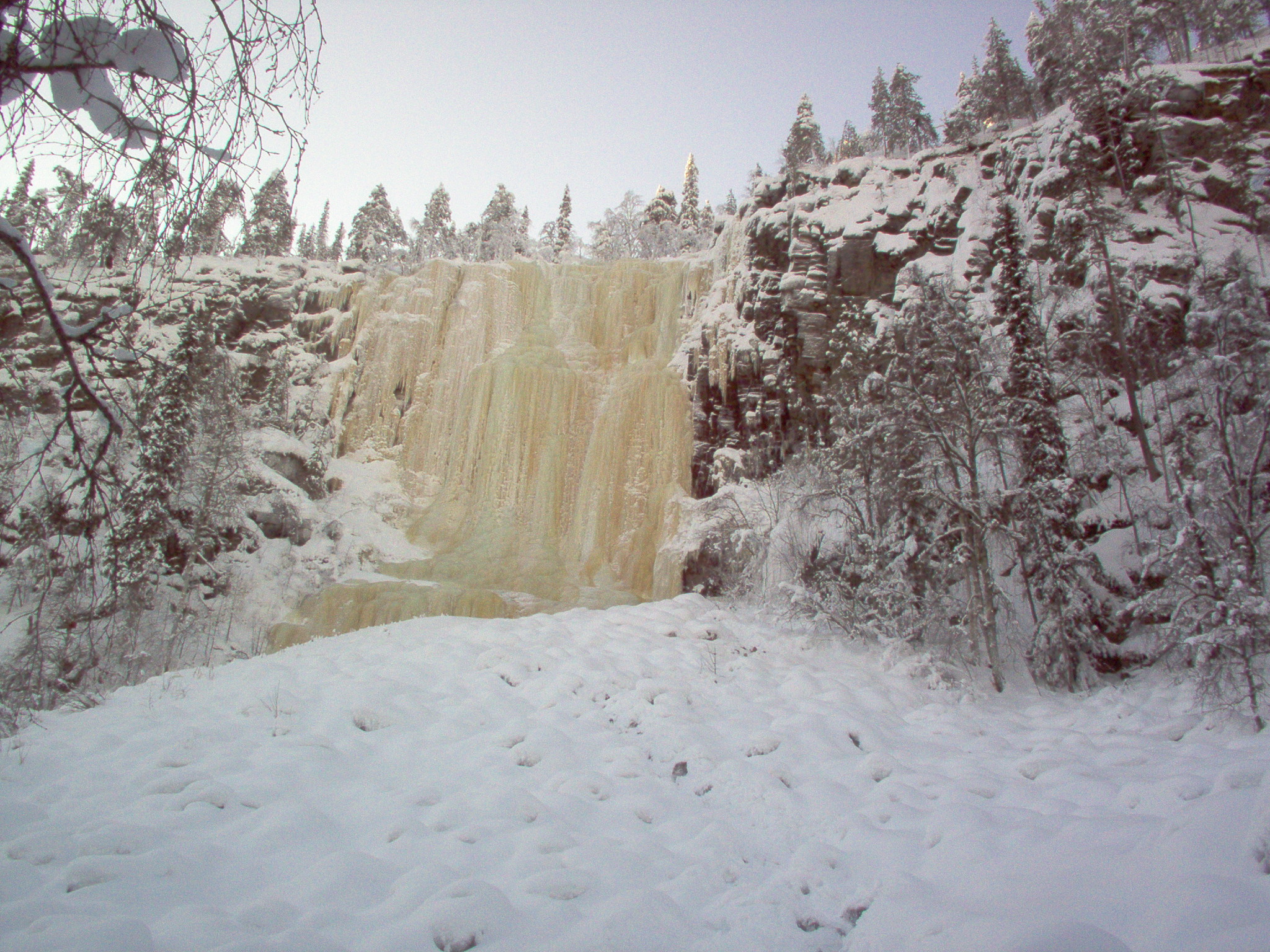
Walls of Ice and Stone
At the heart of the canyon, the fracture valley narrows into a gorge where cliff faces rise tens of meters, nearly vertical. Small streams cascade over these walls year-round, but it is winter that defines Korouoma's character. As temperatures plunge, the water freezes into towering ice formations that persist well into late spring. Climbers from across Finland and beyond come to test themselves on these natural ice walls, ascending routes that shift and reform each season. Summer offers a different kind of challenge: rock climbing routes thread the same cliffs, though the crowds thin considerably once the ice melts. The cliffs themselves are ancient, the exposed bones of a geological fracture that split this landscape long before anyone thought to climb it.
A Valley That Fed and Sheltered
Signs of human use reach back to the late 19th century, though the valley's forests have been worked for far longer. The Korojoki and its tributaries served as log floating routes, and traces of that industry remain visible along the River Kurttajoki at Koivukongas -- remnants of an old flume, the foundations of a loggers' lean-to shelter below Saukkovaara Hill. Farmers from surrounding villages drove cattle and sheep to graze the natural meadows at the canyon floor, mowing grass and storing it in small barns along the riverbank. Bears and eagles preyed on the sheep, a reminder that this was always contested ground. Some of those meadows and barn foundations are being restored now, preserved so future visitors can read the same story in the landscape.
Where Lapland's Ecosystems Converge
Korouoma's ecology is as varied as its terrain. The northern reaches of the valley sit on calcareous soil, producing vegetation noticeably lusher than the southern stretches. Along the Korojoki's banks, flood meadows and herb-rich forests thrive in the moisture-rich microclimate of the canyon floor. Climb the slopes and the character shifts: moderately dry pine forests dominate the Lapiosalmi area, while old-growth spruce and birch cover the hilly terrain beyond the canyon rim. Between the hills, aapa bogs stretch across the lowlands -- open, treeless wetlands characteristic of Northern Ostrobothnia -- alongside spruce-draped hanging bogs that cling to the slopes. The whole reserve is managed by Metsahallitus, Finland's forestry administration, which maintains marked trails, fireplaces, huts, and cabins throughout the canyon.
Into the Gorge
Reaching Korouoma requires commitment. Signs along the Rovaniemi-Posio road point the way, but the canyon itself is not a drive-up destination. A marked hiking trail follows the canyon floor, passing through some of the most striking scenery in Finnish Lapland. In winter, the trail becomes a route through a frozen cathedral, ice formations glinting in whatever light the short subarctic day provides. In summer, the river murmurs over stones smoothed by centuries of flow, and the cliffs cast long shadows across meadows that buzz with insects. Either way, Korouoma rewards the effort of getting there with a landscape that feels genuinely wild -- a crack in the earth where nature has been left to do what it does best.
From the Air
Located at 66.15N, 27.53E near Posio in Finnish Lapland. The canyon runs roughly 30 km and is visible from altitude as a distinct linear fracture in the forested terrain. Nearest airport is Rovaniemi (EFRO), approximately 100 km west. The canyon runs northwest-southeast and is most visible when flying along its axis. In winter, frozen waterfalls on the cliff faces may catch light. The area is well above the Arctic Circle, so polar night conditions apply in December-January.