Kotagede
Inscribed on a square black stone slab in the heart of Kotagede, four languages deliver the same message: So Goes the World. Latin, French, Dutch, Italian -- each carved in a circle on the batu gilang, the stone where Panembahan Senapati, founder of the Mataram kingdom, is said to have rested. Nobody knows who inscribed those European words onto a Javanese relic, or when, but the sentiment fits. Kotagede has watched kingdoms rise and fall from this spot since the late 16th century, its role shifting from royal capital to pilgrimage town to silver-crafting neighborhood without ever quite losing the gravity of a place where something consequential began.
From Forest to Great City
Before it was anything, Kotagede was a forest called Mentaok, east of the Gajah Wong River. In the last quarter of the 16th century, the ruler of Pajang, a kingdom roughly 100 kilometers to the east, awarded the forest to Ki Ageng Pemanahan as a reward for suppressing a rebellion. Pemanahan cleared the land with his son Danang Sutawijaya, who also happened to be the Pajang ruler's adopted son. The settlement took the name Mataram, and when Pemanahan died in 1575, Sutawijaya declared himself king with a title that left nothing to ambiguity: Panembahan Senapati Ingalaga, the Lord to Whom Obeisance is Paid, Commander in the Battlefield. He conquered Pajang itself, swallowing the kingdom of his adoptive father, and the small clearing in the forest became a capital. The Javanese began calling it Kotagede -- the Great City.
The Queen of the Southern Ocean
Senapati understood that military power alone could not hold Java together. According to the Babad Mangkubumi, he sought supernatural alliance through meditation on a stone in a river between Mount Merapi and the Indian Ocean. A mythical fish called Tunggulwulung carried him south to the underwater realm of Kangjeng Ratu Kidul, the most powerful spirit of Java, queen of the netherworld. Overwhelmed by Senapati's spiritual aura, she pledged her support and offered herself as his consort -- and as the consort of every reigning descendant who would follow him. This alliance between the Mataram kings and the Queen of the Southern Ocean persists in Javanese belief to the present day. The dynasty Senapati founded would shift its capital from Kotagede to Kerta, then to Plered, then to Kartasura, and finally to Surakarta and Yogyakarta, but the founding myth always led back here.
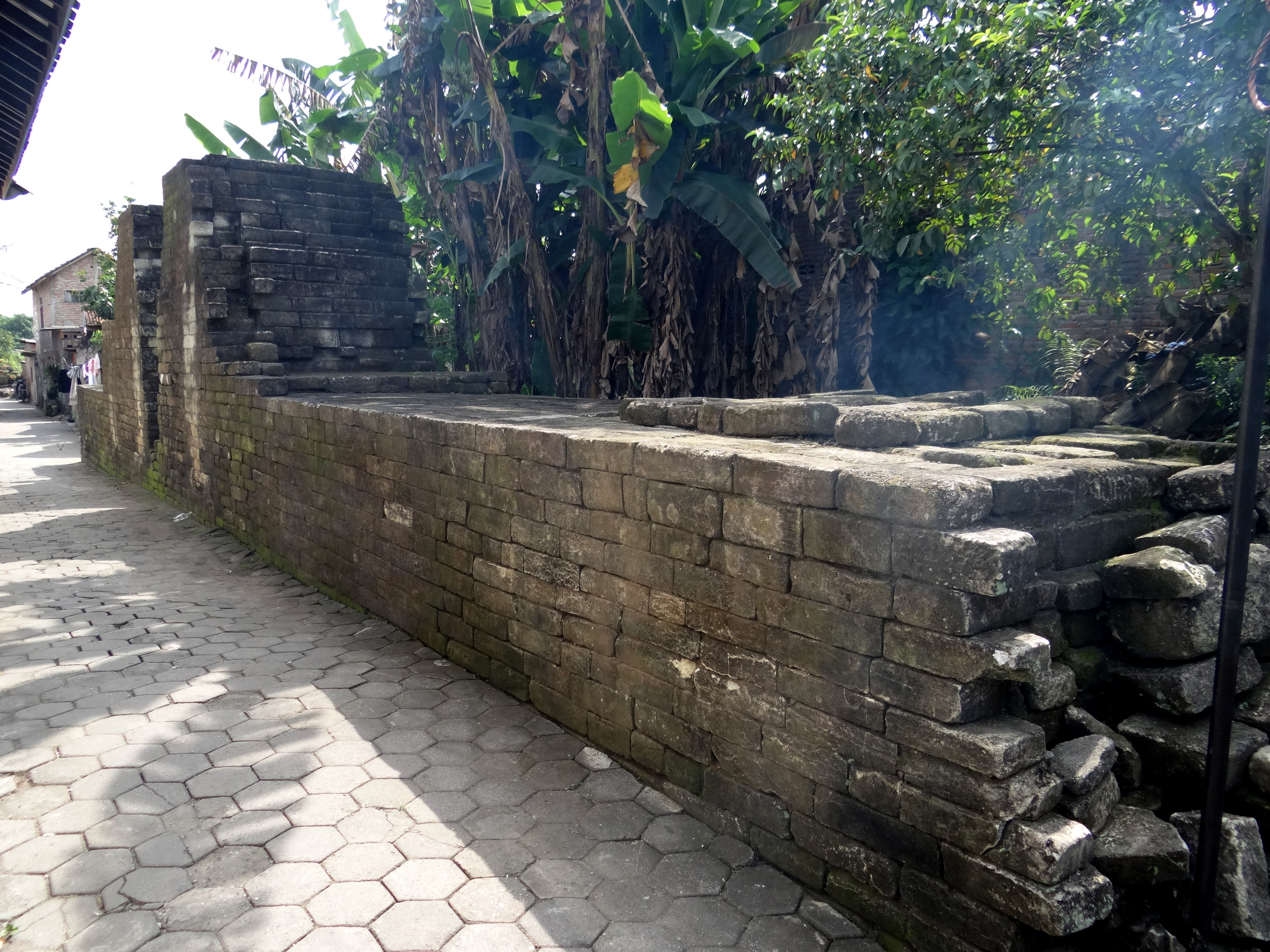
Walls, Moats, and a Bastion Called Semar's Buttocks
Senapati fortified his capital with walls and moats in the manner of Javanese kraton architecture. The inner wall, called the cepuri, enclosed roughly 400 by 400 meters. Along the western edge, the Gajah Wong River served as a natural barrier; on the other three sides, the river was channeled into moats. The walls were four feet thick and built from stone blocks. Today, fragments survive at the southwest and southeast corners. At the southeast corner, a circular bastion still stands. Its rounded form earned it the name Bokong Semar -- Semar's buttocks -- after the beloved clown-god of Javanese wayang puppet theater. An outer wall called the baluwerti extended to the south, where about 50 meters of brick ruins still trace the old defensive line. These physical remnants are modest, but the town's geography preserves what the walls could not: neighborhoods still carry names from the kingdom's era, like Kauman for the quarter of Islamic scholars and Gerjen for the tailors' district.
Silver Beaten by Hand
Walk down Jalan Kemasan, the main street approaching Kotagede from the north, and the sound of small hammers reaches you before the workshops come into view. Silver crafting has been part of Kotagede's identity since the Mataram era, when artisans produced ceremonial vessels and household objects for the royal family using repoussé -- embossing techniques that push the metal into relief from behind. During the 1930s, the Dutch colonial government considered the craft important enough to establish a foundation to protect it. Filigree technique arrived around 1950, brought by craftsmen from Kendari in Sulawesi, and a silversmith named Sastro Dimulyo, working under the company name SSO, pioneered its local adoption. Today Kotagede silversmiths produce filigree, cast pieces, miniature sculptures, necklaces, and rings, all characterized by floral motifs drawn from Hindu tradition -- lotus flowers and leaf patterns beaten into shape by hand.
Heritage Shaken and Revived
The 2006 Yogyakarta earthquake devastated Kotagede's architectural heritage. Traditional wooden joglo houses and the eclectic Kalang merchant houses -- brick-walled structures that blended Javanese and Dutch architectural elements, built during the 18th and 19th centuries when Kotagede's traders prospered -- collapsed across the neighborhood. A coalition led by Pusaka Jogja Bangkit, the Yogyakarta Heritage Revival initiative, began a revitalization program drawing together the Jogja Heritage Society, Gajah Mada University's architecture department, and ICOMOS Indonesia. Some joglo houses have been painstakingly rebuilt, including Omah UGM, purchased and restored by the university. The ancient great mosque, the royal cemetery at Dondongan -- where Senapati lies buried in the direction of his father's feet -- and sections of the original city walls endure. Two palaces, Yogyakarta and Surakarta, still jointly employ juru kunci, ceremonial guardians, to maintain the cemetery. Four centuries after the capital moved on, both courts still claim Kotagede as an inheritance too sacred to divide.
From the Air
Located at 7.82S, 110.40E in the southeastern part of the Yogyakarta urban area, east of the Gajah Wong River. The historic core of Kotagede is visible as a dense neighborhood with the ancient mosque and cemetery complex at its center. Mount Merapi (2,930 m) rises to the north. The Prambanan temple plain lies approximately 10 km to the east-northeast. Nearest airport: WAHH (Adisucipto International Airport), approximately 6 km to the northwest. At low altitude, the remnants of defensive walls and moats are traceable along the neighborhood boundaries.