Kuamoʻo Burials
In December 1819, a question that had simmered since Kamehameha the Great's death six months earlier was settled with rifles, a cannon, and over 300 lives. The question was whether Hawaii's ancient kapu system -- the sacred laws that had governed every dimension of Hawaiian society -- would survive the death of the king who had enforced it. At Kuamoo Bay on the Kona coast, the answer was delivered in blood: it would not. The terraced lava rock at this site still covers the remains of the warriors who fell on both sides, a burial ground that marks the precise moment an entire civilization's spiritual framework was replaced by silence.
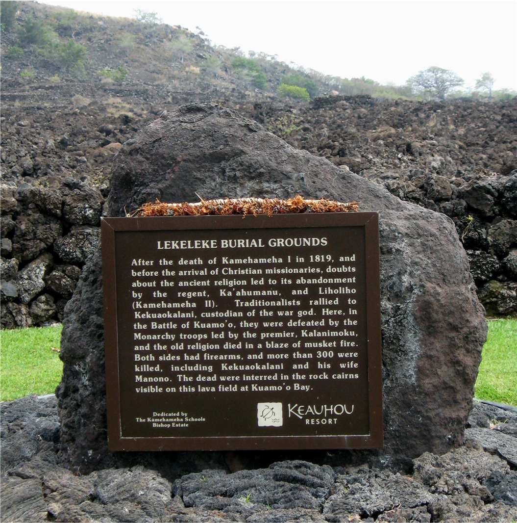
A Kingdom Without Gods
Kamehameha I had unified the Hawaiian Islands through conquest, but he governed them through the kapu system -- an intricate web of religious prohibitions and sacred obligations rooted in centuries of Polynesian tradition. When he died in May 1819, his widow Queen Kaahumanu and his son Liholiho, who took the throne as Kamehameha II, made the extraordinary decision to abolish the kapu entirely. The old temples were abandoned, sacred carvings were burned, and dietary prohibitions separating men and women were lifted. For a brief window, Hawaii had no official religion at all. Christian missionaries would not arrive until April 4, 1820, when the brig Thaddeus anchored at Kailua-Kona -- leaving the islands in a spiritual interregnum unlike anything they had experienced.
The Defender of the Old Faith
Not everyone accepted the new order. Kekuaokalani, Kamehameha I's nephew, stood over six and a half feet tall, with what King Kalakaua later described as "limbs well-proportioned and features strikingly handsome and commanding." He was a member of the priesthood and claimed to be second in religious authority only to the high priest Hewahewa. When the kapu was abolished, Kekuaokalani saw it as the destruction of everything sacred. He gathered followers -- common people who still honored the old traditions -- and marched from Kaawaloa at Kealakekua Bay to confront the royal army. His wife Manono marched with him, a chiefess known for her courage and chiefly status.
Rifles and a Canoe-Mounted Cannon
The two forces met at Lekeleke, near the border between the ahupuaa of Keauhou and Honalo. Both sides carried rifles -- a sign of how thoroughly European technology had already penetrated Hawaiian warfare. But the decisive advantage belonged to Kalanimoku, the royal general: he had a small cannon mounted on a double-hulled canoe, and he used it. Over 300 warriors died in the fighting, including Kekuaokalani and Manono, who were buried together under the lava rocks. The survivors among the traditionalists dispersed and were pardoned. There has not been a battle of comparable size on the island since. The name Kuamoo means "backbone" in Hawaiian, and the site proved to be exactly that -- the spine of the old religion, broken.
Lava Terraces and Living Memory
The remains of the fallen were interred in terraces of lava rock that still stand along the coast near Kuamoo Bay. The battlefield was listed on the Hawaii register of historic places and added to the National Register of Historic Places in 1974. Just to the north lies the Keauhou holua -- an ancient Hawaiian sledding course -- and historic Keauhou Bay. King David Kalakaua, writing in 1888, eulogized Kekuaokalani as "a grand defender of the faith of Keawe and Umi and the altars of the Hawaiian gods," a characterization that reframed the rebel as a tragic hero rather than an enemy of progress. Within a year of the battle, American missionaries Asa Thurston and Hiram Bingham arrived to fill the void. The culture that Kekuaokalani died defending was forever changed, but the lava rock terraces endure -- a quiet monument to the conviction that some things are worth fighting for, even when the fight is already lost.
From the Air
The Kuamoo Burials are located at 19.551N, 155.959W on the Kona coast of the Big Island, near Kuamoo Bay in the North Kona District, a few miles south of Kailua-Kona. The site sits along the shoreline amid lava rock terrain. Best viewed from 2,000-4,000 feet AGL. The Keauhou Bay area to the north is a useful visual reference. Nearest airport: Kona International (PHKO) approximately 10 nm north. The lava rock terraces are visible near the coast but modest in scale from altitude.