Kurumbera Fort
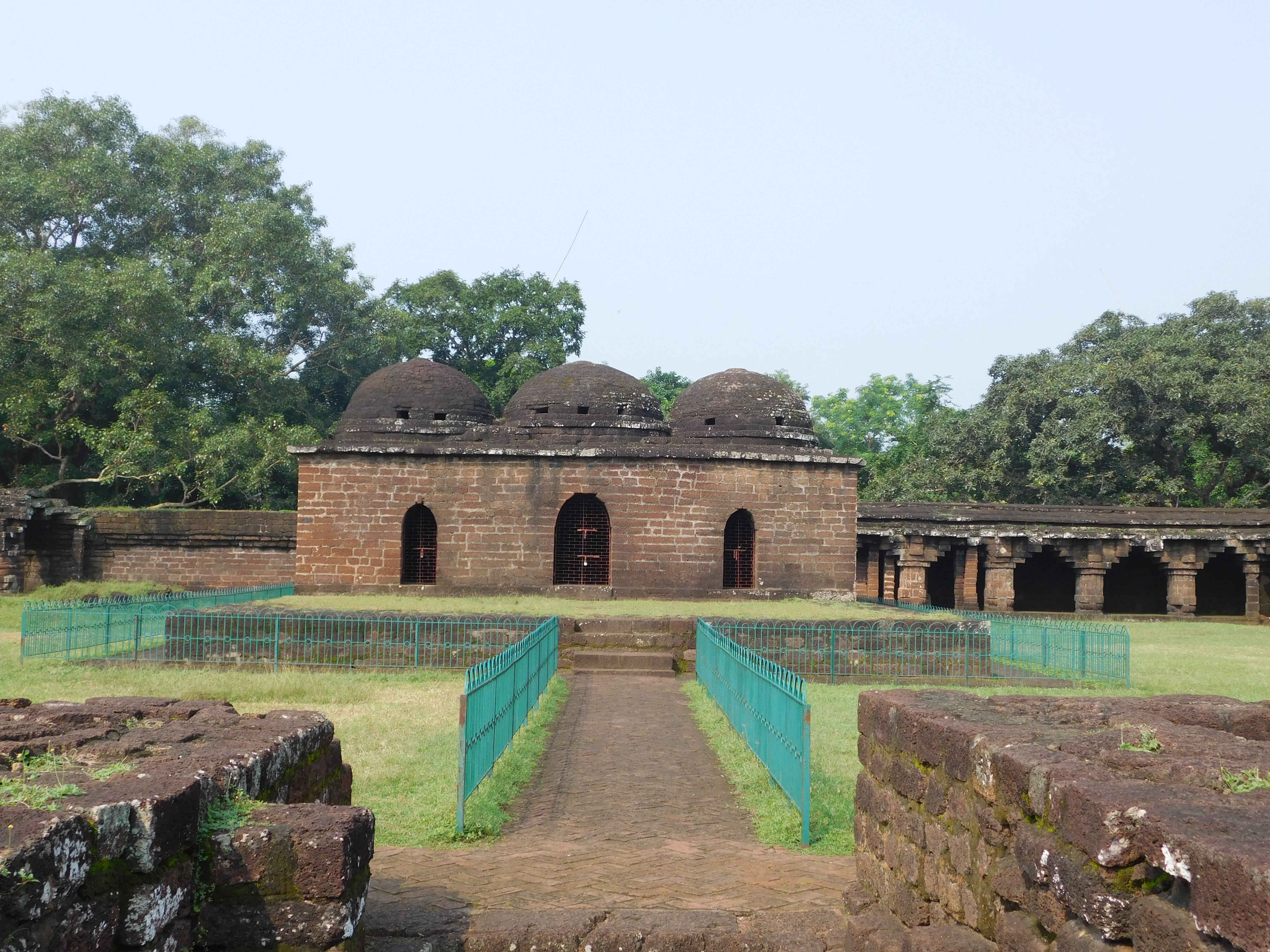
They call it a fort, but nothing about Kurumbera behaves like one. There are no layered walls to repel siege engines, no moat to slow advancing cavalry, no watchtowers scanning the horizon for dust clouds raised by approaching armies. Instead, three spherical domes rise above a pillared courtyard in the village of Gaganeshwar, four kilometers southeast of Keshiari in West Bengal's Paschim Medinipur district. The structure sits in a landscape of rice paddies and laterite soil, reachable only by turning off the state highway at a junction called Kukai and following a concrete road through countryside that time has largely forgotten. Protected by the Archaeological Survey of India, Kurumbera is less a fortress and more a riddle -- a grand public gathering place dressed in the architectural language of medieval Odisha, guarding no weapons, hiding no soldiers, yet inscribed with the names of kings and conquerors who once controlled this land.
Two Inscriptions, Two Empires
An Odia inscription dates Kurumbera's construction to the period between 1438 and 1469, during the reign of Gajapati Kapilendra Deva, the Suryavamsa king whose Odia empire stretched from the Ganges to the Kaveri at the height of its power. A second inscription, carved in stone, records modifications made during the reign of Aurangzeb by a builder named Mohammed Tahir. Between these two markers lies more than two centuries of upheaval: in 1568, the Afghan Sultanate of Bengal and Bihar invaded Odisha, sweeping through the undivided Midnapore district. Seven years later, the Mughals defeated the Afghans at the Battle of Tukaroi in 1575, absorbing Odisha into their expanding administration and dividing it into five Sarkars. Kurumbera survived all of it, accumulating layers of history the way its walls accumulated layers of plaster and lime.
Architecture Without Armor
Walk the structure and a contradiction sharpens with every step. The three domes rest on a raised platform, their curves echoing the architectural traditions of medieval Odisha. Pillars support a roof shaped like an opening flower, with circular columns flanking the rear of the left dome. Stucco and cement mortar -- applied by the ASI to prevent collapse -- shore up external pillars that would otherwise surrender to the monsoons. The resemblance to Raibania Fort in Odisha's Balasore district is unmistakable. Yet Kurumbera has no fortified entrance, no bastions, no secret exits. There is nowhere to store weapons or gunpowder, no place to conceal soldiers or plan an attack. A sacrificial altar occupies the center, and its placement at the western end -- oriented so a gathering crowd would face the same direction -- has led some observers to note the structure's resemblance to a mosque. No written record or oral tradition confirms such use.
A Gathering Place in the Wilderness
The most honest reading of Kurumbera may be the simplest: it was built for people to come together. The vast courtyard, ringed by its pillared corridor, could accommodate a crowd far larger than the surrounding villages would have produced. Perhaps it served as a Durbar hall for regional administrators, or a place where the Gajapati king's representatives met tributary chiefs. Perhaps Mohammed Tahir adapted it for Mughal administrative purposes decades later. Whatever its original function, the building's humility speaks louder than its ambition. In an era when rulers competed to project power through imposing military architecture, someone chose to build a place of assembly -- open, accessible, and undefended. That it survives at all, in a village unreachable by public bus, protected only by an ASI designation and the stubbornness of old masonry, makes its quiet persistence all the more remarkable.
The Road Less Traveled
Getting to Kurumbera requires intention. From Kharagpur, take the state highway 27 kilometers to Keshiari, then turn left toward Belda until you reach the Kukai junction after another two kilometers. A right turn onto a paved road leads to Gaganeshwar village, where the fort waits behind no gate and no ticket counter. Despite its ASI protection status, Kurumbera remains one of the least documented monuments in the survey's extensive inventory. The absence of data has kept it off the tourist circuit, which in turn has kept it quiet. On most days, the courtyard belongs to birdsong and the wind moving through the corridor's pillars. The domes cast long shadows across the platform in the late afternoon, and the inscriptions -- Odia and Persian, separated by centuries -- share the same stone walls as if the empires they represent had always been neighbors.
From the Air
Located at 22.09N, 87.26E in rural Paschim Medinipur district of West Bengal. The fort sits in flat agricultural terrain about 27 km from Kharagpur. Nearest airport is Kalaikunda Air Force Station (VEDX), approximately 25 km northwest. Kolkata's Netaji Subhas Chandra Bose International Airport (VECC) is about 140 km northeast. Best viewed at 2,000-3,000 feet AGL where the domed structures may be visible against the surrounding green fields. Look for the village of Gaganeshwar near the junction of the Keshiari-Belda road.