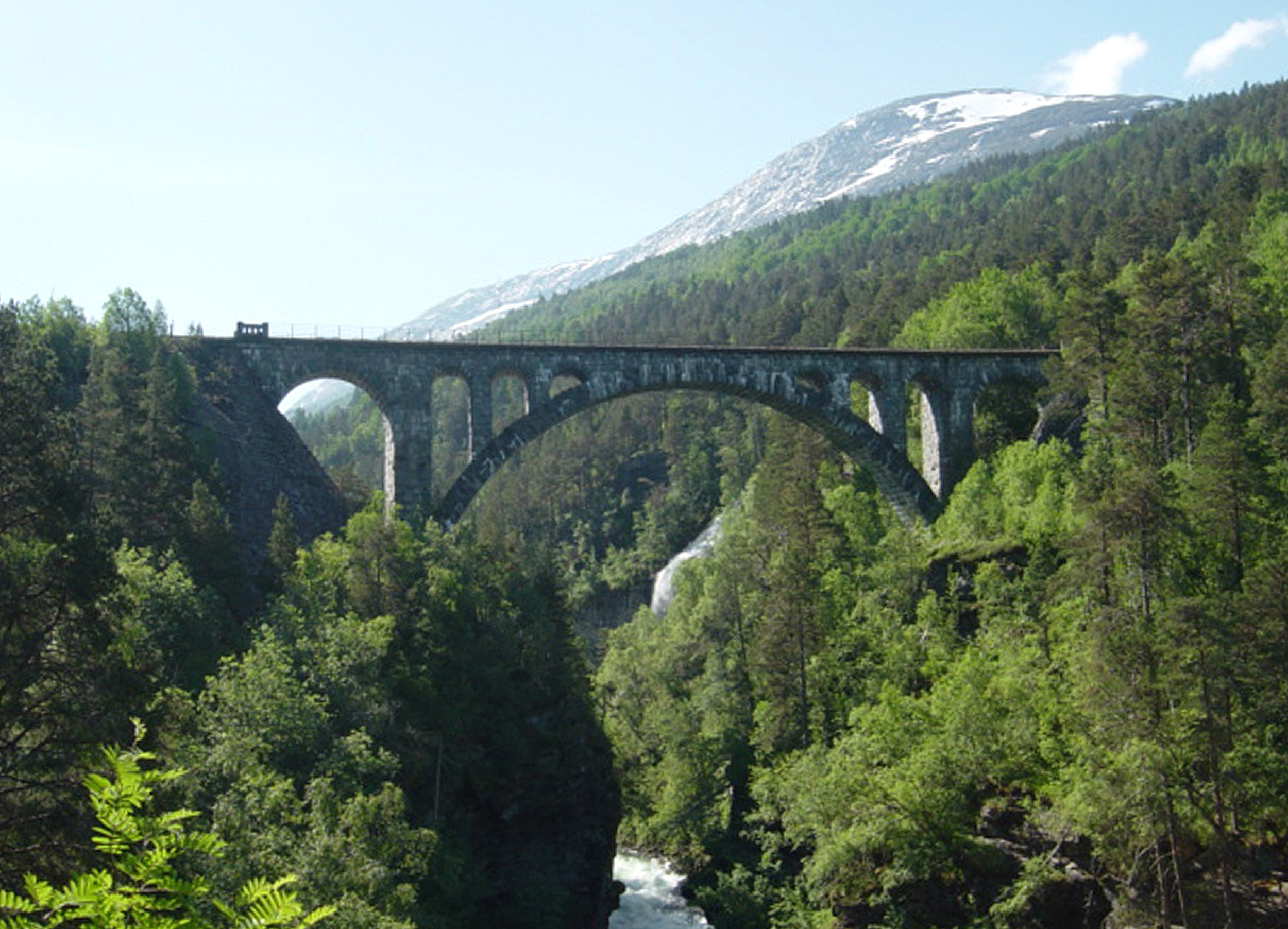
Kylling Bridge
It took nine years to build a bridge that a train crosses in seconds. Construction on the Kylling Bridge began in September 1913, and the last stone was not set until the winter of 1921 -- nearly a decade of work for a 76-meter span of solid gneissic granite arching 59.3 meters above the churning Rauma River. The bridge is the engineering centerpiece of the Rauma Line, the 114-kilometer railway between Dombas and Andalsnes that Lonely Planet has called Europe's most scenic train journey. From the valley floor, looking up at the bridge's single great arch framed against the mountain walls of Romsdalen, it is easy to understand both the accolade and the construction time.
Solving an Impossible Valley
The Romsdalen valley presented railway engineers with a problem that had no easy answer. The valley narrows sharply near the village of Verma, and the terrain drops so steeply that a conventional rail alignment was impossible. The solution was elegant and audacious: a double horseshoe curve. The railway loops back on itself twice, the Kylling Bridge forming the central crossing where the track leaps from one wall of the valley to the other. The main arch spans 42 meters, flanked by side spans of 10 and 8 meters. The entire structure is built from locally quarried granite -- no steel, no concrete, just shaped stone fitted and mortared into an arc that has carried trains for more than a century. At the time of its construction, the bridge cost 676,000 Norwegian kroner, a significant investment that reflected the difficulty of building in terrain where every flat surface had to be created by hand.
The Men Who Built the Line
The Rauma Line was a massive undertaking by any measure. At the start of construction, 615 men were at work along the route. That number dipped to 550 during the lean years of 1917, then rose to 580 after 1918. In total, 14,462,247 working hours were logged to complete the railway -- a figure that captures something of the scale and patience required. Workers blasted tunnels, built retaining walls, and shaped the bridge stones in conditions that ranged from summer heat to winter storms at altitude. The line opened on November 29, 1924, connecting the port town of Andalsnes to the national rail network at Dombas on the Dovre Line. For the first time, the dramatic landscapes of Romsdalen were accessible by train.
One of Norway's Most Photographed Structures
The Kylling Bridge has become one of the most photographed railway structures in Norway, and the reason is composition. The single stone arch, framed by the narrow valley walls and the white-water river below, offers a scene that seems deliberately arranged for the camera. Trains crossing the bridge appear to hang in space between the mountains. The bridge has appeared in international media and film productions drawn to its dramatic setting. From below, the scale is imposing -- 59.3 meters of clear air between the track bed and the river surface. From the train itself, the crossing is brief, a few seconds of rattling over stone while passengers peer down through the windows at the Rauma River far below. The contrast between the effort of construction and the brevity of the crossing is part of what makes Kylling Bridge so striking.
A Journey Worth the Detour
The Rauma Line remains a working railway, carrying both passengers and freight between Andalsnes and Dombas. But it is the scenic reputation that draws most travelers. The route passes through Romsdalen's deepest sections, past Trollveggen -- Europe's tallest vertical rock face -- and across the Kylling Bridge before climbing to the mountain station at Bjorli. The train slows deliberately at the most dramatic points, and during summer months, recorded commentary in multiple languages describes the landmarks. At Kylling Bridge, the train pauses briefly, allowing passengers to absorb the view. Below, the Rauma River rushes through a gorge it has carved over millennia. Above, the mountains close in on both sides. The bridge connects them with an arc of stone that has endured for more than a century, carrying its daily traffic with the quiet confidence of something built to last far longer than the workers who shaped it could have imagined.
From the Air
Kylling Bridge is located at 62.34N, 8.06E near the village of Verma in Rauma Municipality, western Norway. The stone arch bridge is visible spanning the Rauma River gorge in the upper Romsdalen valley. The double horseshoe curve of the railway track is distinctive from the air. The bridge sits in a narrow section of the valley with steep walls on both sides. Trollveggen (Europe's tallest vertical rock face) is visible to the northwest, approximately 15 km away. Nearest airport: Molde Airport, Aro (ENML), approximately 75 km northwest. Andalsnes lies at the valley mouth to the northwest. Altitude recommendation: 2,000-4,000 ft to see the bridge and the horseshoe curve pattern. Look for the white-water Rauma River below the arch.