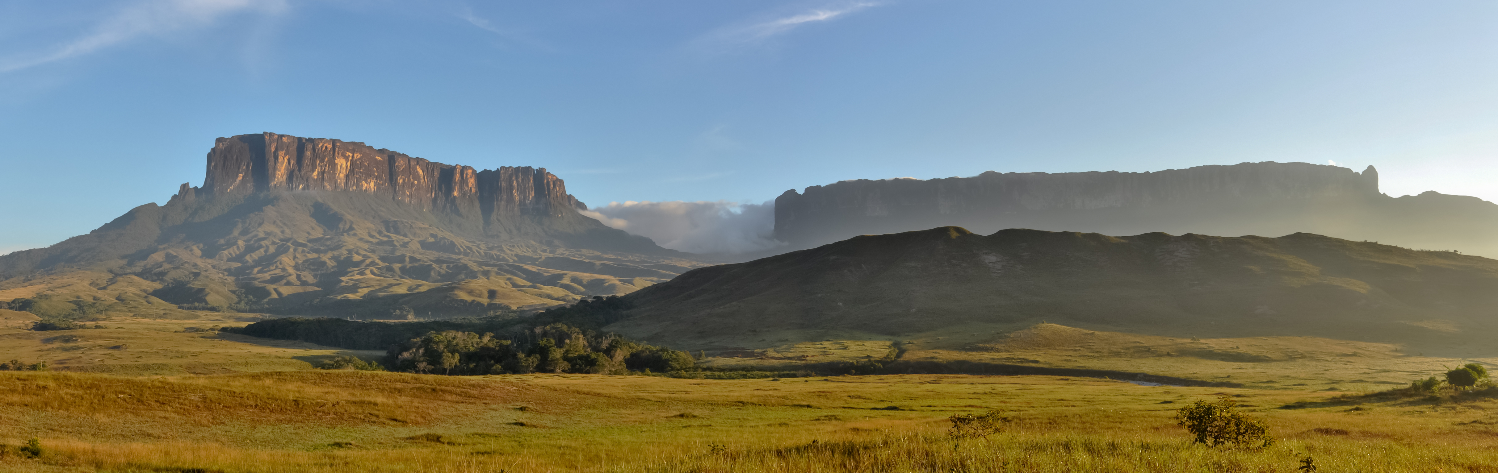
La Gran Sabana
The Pemon people call them tepuys -- houses of the gods. From the air, they look like enormous stone tables abandoned on a green tablecloth, their vertical cliffs dropping hundreds of meters to the savanna and forest below. La Gran Sabana, the great savanna of southeastern Venezuela, sits atop the Guiana Shield, one of Earth's oldest geological formations, and these flat-topped mountains are its defining feature. Scientists call them something equally evocative: islands in time.
Two Billion Years of Patience
The rock beneath La Gran Sabana dates to the Precambrian era, roughly two billion years old. The Guiana Shield's sedimentary layers, rich with gold and diamonds, have been eroding across geological time into the sheer-walled massifs that punctuate the landscape. Roraima, the highest tepuy at around 2,800 meters, was first climbed by Europeans in 1884, and the expedition is thought to have inspired Arthur Conan Doyle's 1912 novel The Lost World. Doyle imagined dinosaurs roaming the summit. The reality is stranger: each tepuy's plateau has evolved its own species of amphibians, insects, and plants in complete isolation. Enormous sinkholes, some 300 meters wide and equally deep, pit the summits like craters, and each sinkhole functions as yet another evolutionary island within the island.
Where Waterfalls Thread the Sky
During the rainy season, every tepuy becomes a waterfall factory. Streams pour over cliff edges in white ribbons that dissolve into mist long before reaching the ground. The most famous of these is Angel Falls, which drops 979 meters from the flanks of Auyan-tepui -- the largest tepuy, whose summit sprawls across nearly 667 square kilometers. But Angel Falls is only the headline act. Across La Gran Sabana, waterfalls emerge from every direction: Chinak Meru near the mission of Kavanayen, the cascades along the road from Santa Elena de Uairen, and dozens more with no names at all, visible only from the air or from trails that few people walk. The Pemon word for this region, tei pun, translates simply as 'the great savanna,' but the water gives it a dimension that the name alone cannot capture.
Frontier at the Edge of Brazil
Santa Elena de Uairen, the largest town in the region with about 25,000 people, sits just eight kilometers from the Brazilian border. Established in the 1930s, it has the rough-edged feel of a frontier outpost where tour operators, miners, and indigenous communities share the same dusty streets. From here, travelers organize treks to Roraima, river trips to Angel Falls from Canaima village, or flights in six-seat planes to missionary settlements scattered across the park. Small airstrips at Kavanayen, Kamarata, El Pauji, and Wonken connect communities that the road network barely reaches. The flights themselves, threading between tepuys at low altitude, offer one of the most dramatic aerial experiences in South America.
The Park as Large as Belgium
All of La Gran Sabana falls within Canaima National Park, a UNESCO World Heritage Site roughly the size of Belgium. It ranks among the world's largest protected areas. Yet protection has limits. Mining for gold and diamonds, prohibited inside the park, continues around its borders, and the environmental scars are visible from the air as brown gashes in the green canopy. The Pemon villages within the park were established in the 1940s and 1950s by Capuchin missionaries, and the indigenous communities now serve as both stewards and guides. Access to certain areas, including Roraima, requires hiring a Pemon guide -- a system that channels tourism revenue toward the people who know this landscape most intimately.
A Pilot's Lost World
At the airport in Ciudad Bolivar, the gateway city on the Orinoco, sits the restored plane of Jimmie Angel -- the American bush pilot who first spotted Angel Falls from the air in 1933. Four years later, he crash-landed his Flamingo monoplane atop Auyan-tepui and spent eleven days hiking out with his wife and two companions. The plane remained on the summit for 33 years before a helicopter retrieved it. Angel's story captures what draws people to La Gran Sabana: a landscape so vast and vertical that it swallows even the ambitious. The tepuys have been standing here for two billion years, indifferent to the adventurers who come and go at their feet.
From the Air
Located at 6.25N, 62.84W in southeastern Venezuela. The tepuys are unmistakable from cruising altitude -- massive flat-topped formations rising sharply from green savanna. Auyan-tepui and Roraima are the most prominent landmarks. Nearest airports: Canaima (SVCN), Santa Elena de Uairen (SVSE), Ciudad Bolivar (SVCB). Best viewed at 5,000-10,000 feet AGL for individual tepuy detail. During the rainy season (May-November), waterfalls are visible streaming from every cliff face. Expect convective weather around the tepuys in afternoon hours.