La Quemada
Nobody agrees on who built La Quemada. Since Fray Juan de Torquemada first wrote about the site in 1615, scholars have proposed it as Aztec, Caxcan, Teotihuacan, Purepecha, Toltec, and Chichimeca -- or none of the above. The ruins sit on a rocky hilltop 56 kilometers south of Zacatecas city, in the dry country between the Valley of Mexico and the northern frontier, and every culture that passed through this corridor has been nominated as its builder. What is not in dispute is how the place got its name: fire. Evidence of burning marks walls and floors across the complex. La Quemada -- "the burnt city" -- ended the way its name suggests.
The Seven Caves and the Long Migration
The most persistent theory links La Quemada to Chicomoztoc, the mythical "Place of Seven Caves" from which the Aztec and other Nahua peoples said they emerged during their great southward migration. Francisco Javier Clavijero made the association explicit in 1780, claiming the Aztecs had stayed here for nine years during their journey to Anahuac. The idea captured the imagination of colonial historians and has never entirely let go. Archaeological investigations since the 1980s have complicated the picture considerably. The site developed between 300 and 1200 AD -- centuries before the Aztec migration stories describe -- and was contemporary with the Chalchihuites culture, a mining-oriented society that worked the mineral-rich hills of northern Zacatecas from the first century AD onward. La Quemada was one node in a trade network that linked Teotihuacan to the northern frontier between 350 and 700 AD, moving minerals, salt, shells, obsidian, and peyote south toward the Valley of Mexico.
Stone on a Hilltop
Everything at La Quemada was built from rhyolite slabs quarried from a hill northeast of the main complex -- a volcanic rock from the granite family, cut into flat pieces and joined with a mortar of clay and plant fiber. The site climbs the hillside in tiers of masonry platforms, each supporting structures that served ceremonial and residential purposes. The southern and southeastern slopes concentrate the most elaborate constructions: sunken patio complexes paired with altar-pyramids, a classic Mesoamerican arrangement. The western terraces appear more residential. Over centuries, builders stacked new structures atop old ones, layer upon layer, each generation covering the work of the last. Today, only fragments of the original clay stucco finishing survive on the walls, eroded by the same dry winds that have been wearing at this hilltop for a thousand years.
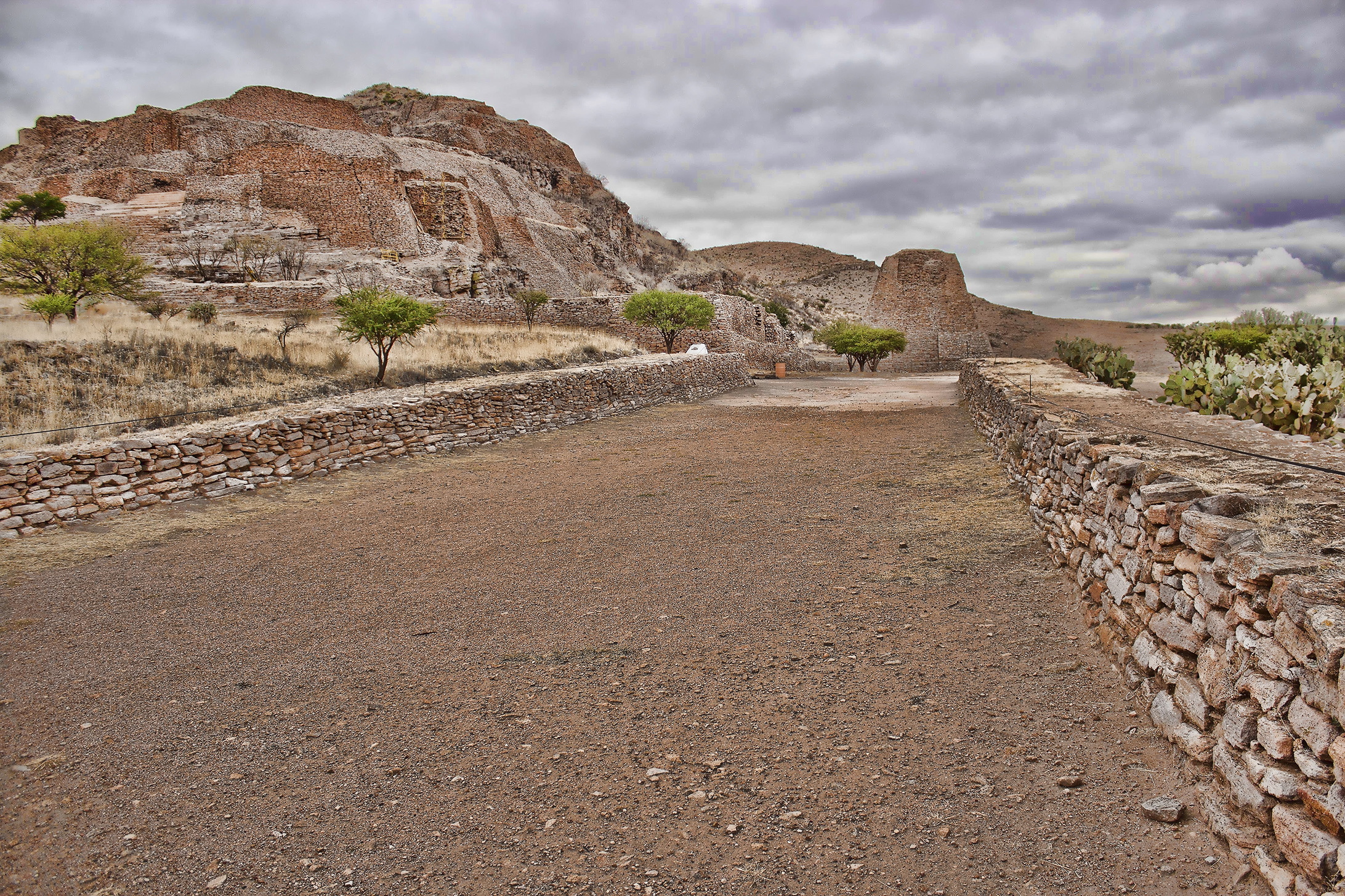
Halls, Roads, and Walls
Three complexes define the site. The Ciudadela, or citadel, anchors the north with a defensive wall 800 meters long, four meters wide, and four meters high. The Palace occupies the center of the hill. The Temple complex closes the southern end. Among the most striking structures is the Salon de las Columnas -- the Hall of Columns -- a 41-by-32-meter enclosure where eleven pillars once supported a roof that may have risen more than five meters. Its exact function remains unknown, though 1950s excavations suggested ceremonial use, possibly involving human sacrifice. Outside the hall, the Calzada Mayor extends 400 meters across the landscape, an engineered avenue with side walls of stone slabs and a surface paved with clay and pebbles. More than 170 kilometers of similar roads radiate through the Malpaso Valley, connecting La Quemada to dozens of smaller satellite sites.
The Burning and the Silence
Between 700 and 1100 AD, La Quemada's role shifted. No longer just a node in a trade network, it became the dominant center in the region -- and began competing with its neighbors. The architecture tells the story of escalating tension: a massive defensive wall rose on the north flank, and at least two internal stairways were deliberately removed to restrict movement within the complex. Then came the fire. Evidence of burning appears throughout the site, and archaeologists infer a violent end to the settlement. The Salon de las Columnas itself appears to have been destroyed by flames. After that, silence. La Quemada was abandoned, its roads leading to satellite communities that no longer answered. The hilltop that had connected Mesoamerica's heartland to its frontier for nearly a millennium stood empty, waiting for the Spanish friars who would eventually give it a name that matched its fate.
From the Air
Located at 22.46N, 102.82W on a prominent hilltop approximately 56 km south of Zacatecas city along Federal Highway 54 (Zacatecas-Guadalajara). The archaeological site is visible from the air as terraced stone ruins climbing a rocky hill above the Malpaso Valley. Look for the long Calzada Mayor extending from the site across the valley floor. Elevation approximately 2,200 meters. Nearest airport: General Leobardo C. Ruiz International (MMZC/ZCL) in Zacatecas, approximately 60 km north. Terrain is semi-arid with scattered hills -- maintain safe altitude.