La Tuna Fire
September in the Verdugo Mountains is dry tinder. The hills above Burbank and Glendale are chaparral country — dense scrub that evolved to burn, adapted over millennia to a fire cycle that human development has compressed and complicated without eliminating. On September 1, 2017, shortly before 1:30 in the afternoon, fire broke out in La Tuna Canyon. By nightfall it was burning in four directions at once. By the following night it had consumed 5,800 acres. When it was fully contained, nine days later, it had burned 7,194 acres and become the largest wildfire in the history of the City of Los Angeles.
Labor Day Weekend, 106 Degrees
The La Tuna Fire was first reported on a Friday afternoon, at the start of a holiday weekend, under conditions that made it difficult to fight: temperatures up to 106°F, relative humidity as low as 16 percent, and the kind of dry, gusting winds that turn embers into artillery. By 4:00 p.m. the fire had established itself on both sides of Interstate 210, and the California Highway Patrol closed the freeway between Lowell Avenue and Sunland Boulevard. By 9:30 p.m., 1,500 acres had burned.
Mandatory evacuation orders went out for neighborhoods in Glendale, Burbank, and the Sunland-Tujunga community. Los Angeles Mayor Eric Garcetti declared a local emergency on Saturday night. California Governor Jerry Brown declared a state of emergency for Los Angeles County. By that point, 1,061 firefighters were on the fire with 206 engines, 9 helicopters, 5 water tenders, and 4 dozers. One hundred firefighters who had been deployed to assist with Hurricane Harvey relief in Houston were recalled to Los Angeles.
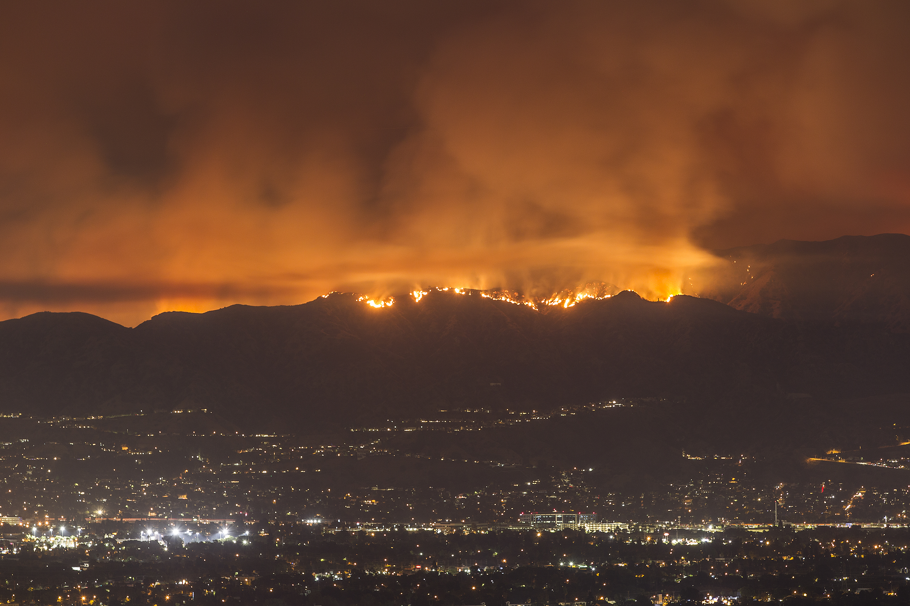
The Work of Containment
The fire burned for nine days. Smoke became trapped beneath an atmospheric inversion — a layer of warm air above cooler air near the surface — and settled over Burbank and the eastern San Fernando Valley in a gray-brown haze. The South Coast Air Quality Management District issued advisories telling affected residents to stay indoors. At times, air quality meters registered dangerous levels.
The containment lines advanced when conditions allowed: when wind speeds dropped, when humidity climbed slightly at night, when air tankers could operate without being buffeted off course. Ground crews worked in the canyon terrain — steep, brushy, with limited access — while helicopters made water drops from above. The fire was fully contained on September 9. On October 26, 2017, the Los Angeles Fire Department closed its investigation into the fire's origins without determining a cause. The report stated that the fire was "not suspicious in nature" and showed no evidence of arson. The cause has never been determined.
The Verdugo Mountains After Fire
The Verdugo Mountains are a small, isolated range rising above Burbank and Glendale — the hills visible from the 5 and 210 freeways that form the distinctive skyline of the northeastern Los Angeles Basin. They are not wilderness in any pristine sense; they are surrounded on all sides by dense urban development. But they are genuine open land, and the fire burned through them with the thoroughness that chaparral fires achieve.
In the aftermath, the blackened hillsides turned green within a single rain season. Chaparral is built for this: many of the shrubs that form it, including chamise and toyon, sprout from root crowns that survive fire underground. The La Tuna Fire destroyed five homes and five outbuildings and caused at least ten injuries. The loss was real and specific for those families. For the mountain ecosystem, fire is not an aberration but a recurring event — one that clears the old growth and makes room for what comes next. The fire also inspired the formation of the volunteer-based La Tuna Canyon Fire & Rescue department, established to improve local emergency preparedness.
From the Air
The La Tuna Fire burned through the Verdugo Mountains at approximately 34.23°N, 118.27°W, a compact range rising above Burbank and Glendale between the I-5 and I-210 corridors. The fire-scarred terrain on the south and west faces of the range is visible from the air on approaches to Burbank (KBUR), which is 3 miles SW. La Tuna Canyon Road runs through the burn area. Best viewed at 3,000–5,000 ft AGL.