Laguna de Apoyo
The water is warm. Not sun-warmed, the way a shallow pond heats up on a summer afternoon, but geothermally warm -- heated from below by the residual energy of the volcano that created this place. Laguna de Apoyo sits inside a caldera roughly six kilometers across, a nearly circular basin punched into the Nicaraguan highlands between the cities of Masaya and Granada. The lake has no river feeding it and no river draining it. Rainfall and volcanic springs fill it; evaporation and seepage take the water away. The result is a body of water so transparent it makes nearby Lake Cocibolca look like milk by comparison.
A Crater You Can Swim In
From the surrounding plateau, the lake surface lies about 150 meters below the rim. One paved road descends from the northwest, dropping steeply through the crater wall to reach the shoreline at a junction the locals call El Triangulo. Because this is a crater lake, the bottom drops away sharply -- wade a few steps from shore and the lakebed falls at nearly 45 degrees beneath your feet. The maximum depth reaches 175 meters, making Apoyo one of the deepest lakes in Central America relative to its modest diameter. Being volcanic, the water stays pleasantly warm in every season, warm enough that a wetsuit would be absurd. Trade winds blow from the east and southeast, which means the sheltered southeastern bays can be glassy calm while the northwestern shore, where most of the hotels cluster, takes the full force of wind-driven waves.
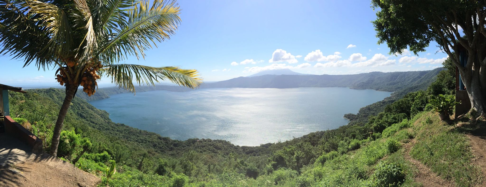
The View from Catarina
The best way to grasp the scale of Laguna de Apoyo is from the village of Catarina, perched on the crater's southern rim. From the mirador there, the entire laguna spreads out below -- a near-perfect circle of blue-green water ringed by forested slopes that plunge to the shoreline. The Laguna de Apoyo Nature Reserve protects the crater and its drainage area, preserving the forested slopes that keep the water clean. Because the catchment is small, with almost no agriculture or settlement on the steep inner walls, the lake has avoided the pollution that plagues larger Nicaraguan waterways. The southern shore remains largely wild, accessible only by kayak or by cow trails that descend from the plateau above.
Life on the Hotel Strip
Over a dozen small resorts and hostels line the northwestern shore, strung along a road that runs parallel to the water from El Triangulo. This is the laguna's only developed stretch. A school, a couple of small grocery stores, and a few comedores make up the local infrastructure. Much of the beach frontage belongs to private resorts that charge day-use fees for access to their docks, hammocks, and kayaks. Public beach sections exist between the properties, though they tend to be more crowded. Getting here without a car means catching one of the three daily buses from Masaya -- old North American school buses that make the leisurely 16-kilometer ride in about an hour, stopping on demand along the way. Bicycles and oversized luggage go on the roof.
Paddling Against the Wind
Kayaking is the best way to explore beyond the hotel strip. Experienced paddlers set out early in the morning, when the wind is lightest, heading east into the prevailing breeze. The logic is simple: paddle against the wind while you are fresh, then ride the waves home in the afternoon. A circumnavigation reveals shores that most visitors never see -- the wild southern coast where no buildings stand, the northeastern corner where private villas perch on high ground with paths switchbacking down to the water, and the eastern rim where a rough footpath shared with local cattle drops from the farmland above to a swimming spot with a view of the entire crater. Navigation has its own challenge: from the water, every resort looks the same, a low-slung building backed by green slopes. Locals recommend memorizing the names of neighboring properties, because when you paddle up to a stranger's dock asking for directions, they will know the name of their own place but probably not yours.
From the Air
Located at 11.92N, 86.03W between the cities of Masaya and Granada in western Nicaragua. The crater is approximately 6 km in diameter and strikingly circular from altitude, making it one of the most recognizable volcanic features in the region. Best viewed from 5,000-8,000 feet AGL where the full caldera shape is visible. The dark blue water contrasts sharply with the surrounding green terrain. Nearest airport: Augusto C. Sandino International (MNMG) in Managua, approximately 20 nm northwest.