Laguna Lejia
Scientists looking for Mars came to the Atacama. Specifically, they came to Laguna Lejia, a shallow salt lake perched at 4,325 meters in the Puna de Atacama, surrounded by volcanoes and stripped by wind to a present-day surface of just 1.9 square kilometers. What drew the astrobiologists was not the lake's size but its story: during the last ice age, Lejia swelled to 10 square kilometers and filled with freshwater, building stromatolites and bioherms along its shores. Then the climate shifted, the water shrank, and the microbial ecosystems adapted or died. The parallels to ancient Martian lakes — particularly Jezero crater, where NASA's Perseverance rover hunts for signs of past life — are close enough that researchers have used Lejia as a terrestrial analog for understanding what habitable environments look like as they dry up and vanish.
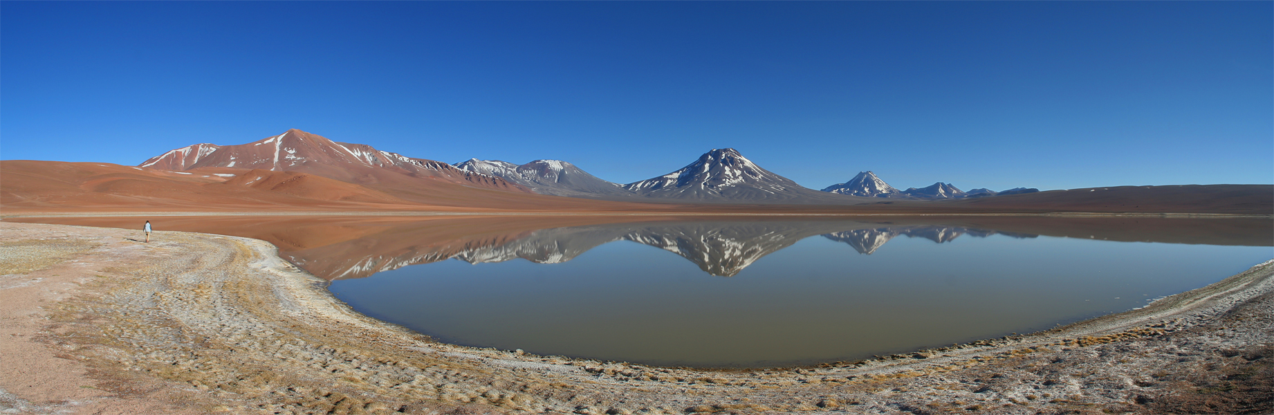
Ringed by Fire
Laguna Lejia sits in a tectonic depression within a 193-square-kilometer catchment, encircled by volcanoes that have shaped and reshaped the landscape for millennia. Lascar, one of Chile's most active volcanoes, looms to the north — its 1993 eruption sent ash and pyroclastic material directly into the lake. To the south and west stand Chiliques, Tumisa, and the Cordon de Puntas Negras volcanic chain. A lava flow forms the lake's southern shore, a reminder that the geology here is not merely scenic but actively in motion. Cerro Overo, a nearby maar — a shallow crater formed by groundwater-magma interaction — adds yet another volcanic feature to a basin where the boundary between liquid and fire has always been thin. Two creeks from Aguas Calientes and Lascar feed the lake from the north, while streams from Chiliques enter from the south.
When the Lake Was an Inland Sea
During glacial periods, decreased evaporation and increased precipitation transformed Lejia from a shallow salt puddle into a freshwater lake five times its current size. Water levels rose roughly 25 meters above their present mark, and bioherms — mound-like structures built by microbial communities — developed around the expanding shoreline. A volcanic marker tephra erupted by the Cerro Corona lava dome, dated to approximately 16,700 years before present, predates the lake's highstand, helping geologists bracket the timing of these wetter conditions. Lake levels remained elevated into the Holocene before declining to the saline remnant visible today. The terraces left by those ancient shorelines still ring the lake, preserving stromatolite remnants that record how microbial ecosystems responded to each swing between wet and dry. Even the larger Soncor eruption from Lascar, some 26,450 years ago, left its signature in the lake sediments.
Life at the Edge of Possibility
Despite average temperatures hovering around 2 degrees Celsius and precipitation of just 200 millimeters per year — most of it during the summer months and far below the annual evaporation rate — Laguna Lejia supports a community of organisms adapted to extremes. Diatoms colonize the water, including species like Amphora coffeaeformis and Navicula halophila that tolerate high salinity. Algae and their parasites maintain their own microscopic food web. Along the shoreline, tough grasses and cushion plants of the Puna cling to the margins where moisture gathers near springs. At lower elevations in the catchment, bunch grass and shrub vegetation provide sparse cover, giving way above 4,500 meters to the rosette plants and cushion species that define the high Puna's distinctive, carpet-like vegetation. Flamingos visit the lake, adding improbable splashes of pink to a landscape dominated by brown, white, and volcanic black.
Hunters on the High Terrace
Archaeological artifacts from the archaic period have been found on an upper terrace of Laguna Lejia, evidence that ancient hunters traveled to this altitude despite its punishing conditions. The lake, even in its diminished state, would have attracted game animals to its shores, and the surrounding Puna grasslands supported the vicunas and guanacos that Andean peoples hunted for millennia. The artifacts suggest that these high-altitude environments were not barriers to human movement but waypoints in a network of seasonal routes connecting the Pacific coast to the Altiplano. The lake's position — 103 kilometers southeast of San Pedro de Atacama, near the Argentine border — places it along pathways that traders and hunters used for thousands of years before Spanish colonization disrupted those patterns.
A Mirror in the High Desert
From the air, Laguna Lejia appears as a small, reflective patch surrounded by the muted tones of the high Atacama — tan volcanic slopes, dark lava flows, and the pale mineral deposits left by vanished shorelines. The lake's salinity creates zones of different color and opacity, and depending on season and angle, the water can appear turquoise, white, or nearly invisible against the salt-crusted margins. The ring of ancient terraces is discernible from altitude, concentric lines tracing the memory of a larger, wetter world. Farther south, the sister lakes of Laguna Miscanti and Laguna Miniques sit in their own volcanic amphitheaters. The clarity of the atmosphere at this altitude — the same transparency that makes the Atacama a premier site for astronomical observatories — renders the entire scene with a sharpness that feels almost artificial.
From the Air
Laguna Lejia lies at approximately 23.50°S, 67.69°W at an elevation of 4,325 meters (14,190 feet) in Chile's Puna de Atacama, close to the Argentine border. From altitude, the lake appears as a small reflective surface surrounded by volcanic peaks including Lascar, Chiliques, and the Cordon de Puntas Negras. The sister lakes Laguna Miscanti and Laguna Miniques are visible to the south. The nearest airport with services is El Loa (SCCF) at Calama, approximately 150 km to the northwest. San Pedro de Atacama lies 103 km to the northwest. Extreme altitude and thin atmosphere provide exceptional visibility but significant density altitude challenges for aircraft. No airports exist near the lake.