Lahaina, Hawaii
The name itself is a curse at the sky. A bald-headed chief, so the story goes, walked the Kauaula Valley without shade and looked up at the relentless sun: "He keu hoi keia o ka la haina!" -- "What a merciless sun!" The name stuck. Lahaina sits in the rain shadow of the West Maui Mountains, one of the driest places in Hawaii, where the sun burns down on a narrow coastal strip that has served as a seat of kings, a haven for whalers, a missionary battleground, and a tourist destination -- before fire took nearly all of it in a single August afternoon.
Kingdom at the Water's Edge
Long before its modern name, this place was called Lele -- "to leap" or "to fly" -- for the way the land juts into the sea. The aliʻi nui Piʻilani was the first to unite all of Maui under one rule from here, extending his sovereignty over Lanaʻi, Kahoʻolawe, and parts of Molokaʻi. By 1802, Kamehameha the Great had stationed his fleet of peleleu war-canoes along Lahaina's shore as he consolidated his grip on the entire island chain. His wife Kaʻahumanu refused to live in the western-style Brick Palace he built for her, choosing a traditional Hawaiian home just feet away -- a quiet act of cultural defiance that set the tone for the tensions to come. Kamehameha III later ruled from the sacred island of Mokuʻula, set within a spring-fed pond in the middle of town, and signed the first Hawaiian constitution here on October 8, 1840. Lahaina was the capital until 1845, when the growing commercial pull of Oʻahu drew the court to Honolulu.
Grog, Gunpowder, and God
When New England whaling ships began arriving in 1819, Lahaina transformed into the rowdiest port in the Pacific. Sailors who had spent months hunting sperm whales came ashore desperate for drink and companionship. The Hawaiian chiefs, influenced by American missionaries, imposed a kapu prohibiting women from visiting the ships. The whalers were furious. Riots erupted in 1825, 1826, 1827, and 1843 -- in one incident, a British whaling ship fired cannon shots over missionary William Richards's home. Governor Hoapili responded by building a coral-block fort on the waterfront in 1831, topped with 47 cannons. The fort confined unruly sailors under a sunset curfew: if the drums sounded and you were still ashore, you slept in a cell. But the whaling economy was Hawaii's lifeline, and the tension between commerce and morality defined Lahaina for decades. The industry's decline after the discovery of Pennsylvania oil in 1859 and the Civil War left the town quietly fading into the sugarcane era.
Front Street and the Banyan's Shade
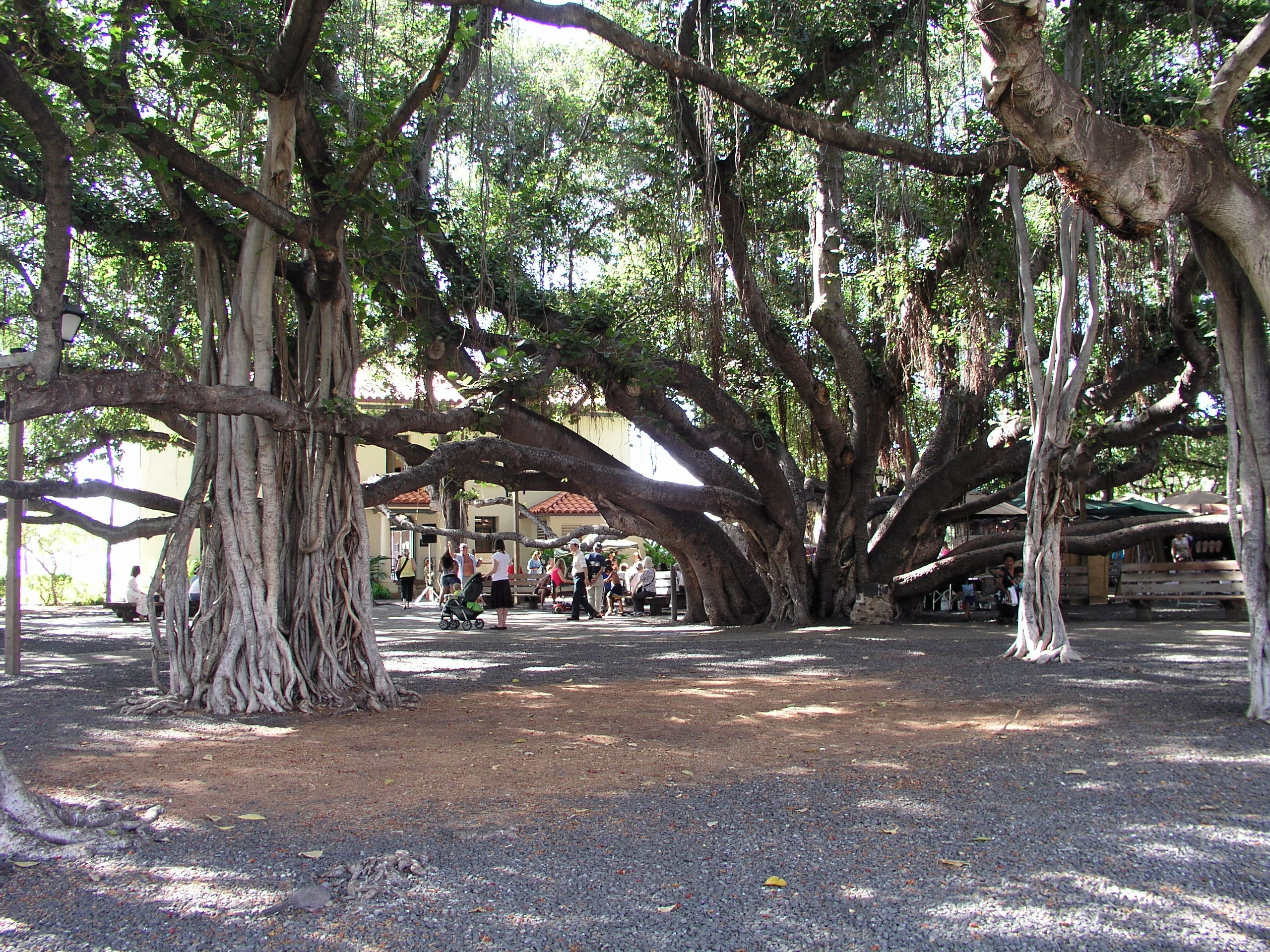
By the twentieth century, Lahaina had reinvented itself again. Front Street, lined with galleries, restaurants, and surf shops, earned a spot on the American Planning Association's list of Top Ten Greatest Streets. The Lahaina Historic District encompassed 60 sites managed by the Lahaina Restoration Foundation. At its heart stood the banyan tree planted in 1873 by Sheriff William Owen Smith -- an eight-foot seedling from India that grew to cover two-thirds of an acre with 16 trunks. Each evening, common myna birds roosted in its canopy, their cries building to a cacophony as the sun dropped behind Lanaʻi. The Pioneer Inn, built in 1901, anchored the harbor. Whale-watching boats launched from the small-boat harbor where humpbacks breached offshore every winter. Halloween drew thirty thousand costumed revelers to Front Street in what locals called the Mardi Gras of the Pacific.
August 8, 2023
The fire moved faster than anyone expected. Driven by winds from a passing hurricane, flames swept through Lahaina on August 8 and 9, 2023, destroying approximately 80 percent of the town and killing 102 people -- the deadliest wildfire in the United States in over a century. The Old Lahaina Courthouse, built in 1859 from coral blocks salvaged from the demolished fort, was gutted; only its charred outer walls remained standing. The Pioneer Inn was lost. Waiola Church, which had already burned and been rebuilt multiple times since 1823, burned again. The banyan tree was scorched but survived, its blackened trunk sending out green shoots in the months that followed. The King Kamehameha III Elementary School, the library, and block after block of homes and businesses were reduced to ash. Lahaina's population of 12,702 was displaced overnight.
What Remains, What Returns
Rebuilding has been slow and contested. In 2024, Maui County released plans for reconstructing the commercial district, infrastructure, and affordable housing, with a six-year timeline. The 2023 disaster reignited calls to restore Mokuʻula, the sacred royal island buried beneath a baseball field since 1919, and to return water to the Mokuhinia wetlands that the sugar industry had drained. Governor Josh Green pledged unilateral action. For many Native Hawaiians, the fire exposed something that had been true for generations: that Lahaina's layers of history -- Polynesian, royal, missionary, whaling, plantation, tourist -- had always been in tension, and that rebuilding meant choosing which layers to honor. The banyan tree, scarred but alive, stands as the most visible symbol of that choice.
From the Air
Lahaina sits at 20.886N, 156.675W on Maui's northwest coast. From the air, the town is visible as a narrow coastal strip between the West Maui Mountains and the ocean. The burn scars from the 2023 wildfire are clearly visible from altitude. Kapalua Airport (PHJH) is 6 nm to the northwest; Kahului Airport (PHOG) is 23 nm to the east. Best viewed at 2,000-4,000 feet for town detail. The island of Lanaʻi is visible across the Auʻau Channel to the west.