Lake Abbe
Fifty-meter limestone chimneys rise from a flat expanse of salt, venting steam into air so hot and dry it seems to evaporate before it climbs. The landscape looks like it belongs on another planet — so much so that Djiboutian tour guides have long claimed the shores of Lake Abbe stood in for the alien world in the 1968 film Planet of the Apes. That story is a myth; the film was shot in Arizona and California. But the myth's persistence speaks to something real about this place. The geology here is not fiction. Lake Abbe sits at the Afar Triple Junction, the single point where three tectonic plates, the African, Arabian, and Somali, are pulling away from each other. The continent is splitting apart beneath your feet. Everything about this place, the chimneys, the salt flats, the boiling springs, the shrinking lake, is a consequence of that slow, relentless tearing.
Where the Earth Comes Apart
The Afar Triple Junction is one of the few places on the planet where a continental rift can be observed above sea level. Three pieces of Earth's crust are separating here, though not all at the same speed, and the result is the Afar Depression, a geological wound that has been widening for millions of years. Lake Abbe sits at its heart, the terminal destination of the Awash River, which flows northeast from the Ethiopian highlands through a chain of six connected lakes before ending here with no outlet to the sea. Water flows in carrying dissolved minerals, and pure water evaporates from the surface, concentrating salt with every cycle. The lake is hypersaline, an amplifier lake whose level fluctuates dramatically in response to small climate changes. On its northwest shore, the dormant volcano Mount Dama Ali rises to 1,069 meters. Along the southwestern and southern shores, salt flats extend ten kilometers wide, blindingly white under the equatorial sun.
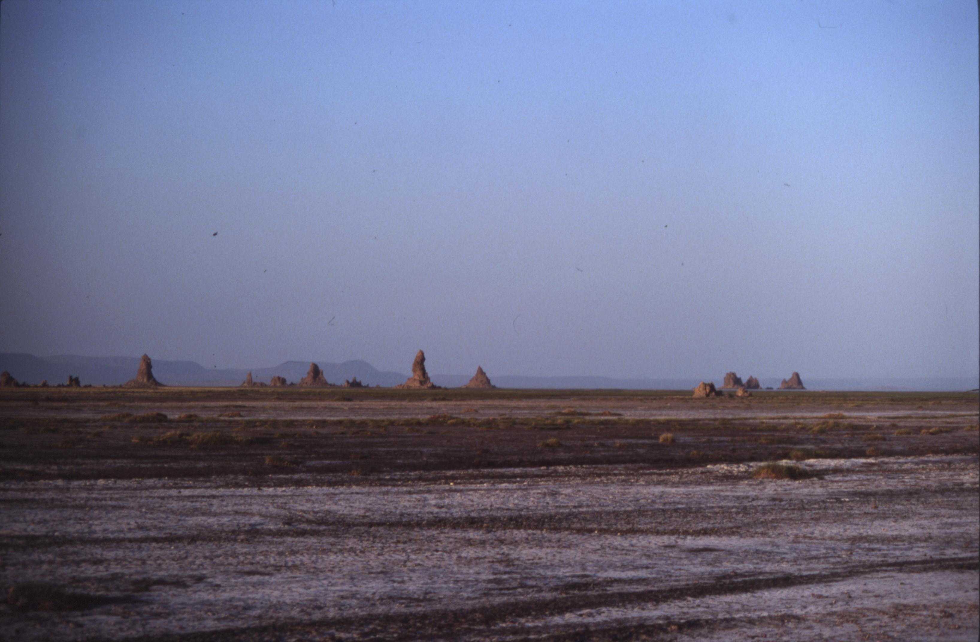
The Chimneys
Lake Abbe's most striking features are its carbonate chimneys, towering columns of limestone that reach heights of 50 meters and vent geothermal steam from their tops. They form where lake water mixes with deeper geothermal fluid, precipitating calcium carbonate into structures that look like they were designed by a sculptor with an appetite for the surreal. At dawn and dusk, when the low sun catches the steam and the chimneys cast long shadows across the salt flats, the landscape becomes genuinely otherworldly. The chimneys are not static. They grow, erode, and reform as the lake level changes and geothermal activity shifts. Some stand alone like solitary sentinels. Others cluster together in groups that suggest ruined architecture. The steam that emerges from them is a visible reminder that the mantle is close to the surface here, heating groundwater that has percolated down through fractured rock.
A Lake That Is Disappearing
Lake Abbe is shrinking. By 1984, its surface area had decreased to two-thirds of what it was in 1940. During that period, roughly 11,500 hectares of new salt flats formed to the southwest. The causes are both climatic and human. Recurring droughts have reduced inflow, but the more significant factor is the extraction of water from the Awash River for irrigation upstream. Every liter diverted for agriculture is a liter that never reaches the lake. The consequences ripple outward. Flamingos, which gather on the lake's waters in flocks visible from the air, depend on the lake's particular chemistry and depth. As the lake recedes, their habitat contracts. The climate offers no relief: annual rainfall averages less than 172 millimeters, summer temperatures sit between 30 and 45 degrees Celsius, and even the coldest months rarely dip below 21 degrees. Lake Abbe is considered one of the most inaccessible places on Earth, reachable only by rough tracks through the Afar lowlands.
The People of the Furnace
The Afar people have maintained a settlement near Lake Abbe's shore, living in one of the most extreme environments inhabited anywhere on the planet. The Afar are pastoralists and salt traders who have adapted to the Depression's brutal heat over centuries. Their presence here is not incidental. The salt flats that form as the lake recedes are a resource, and salt from the Afar Depression has been traded into the Ethiopian highlands for generations, carried by camel caravans along routes that predate recorded history. The seasonal wadis, the Oleldere and Abuna Merekes, that cross the salt flats from the west and south are the lifelines of this settlement, providing intermittent water in a landscape that otherwise offers none. Living beside Lake Abbe requires an intimate understanding of the land's rhythms: where water will appear, when salt can be harvested, which routes the camels can travel. It is a knowledge measured not in years but in generations.
From the Air
Located at 11.17N, 41.78E on the Ethiopia-Djibouti border in the Afar Depression. The lake and its limestone chimneys are dramatic from altitude, especially at dawn when steam is most visible. The salt flats and shrinking lake surface are clearly visible from above 5,000 feet. Mount Dama Ali (1,069m) on the northwest shore is a useful visual reference. Nearest airport is Djibouti-Ambouli (HDAM), approximately 100 miles to the east. Extreme heat and minimal landmarks make GPS navigation essential. The terrain is flat desert and salt flats surrounding the lake basin.