Lake Batur
On the morning of June 19, 2011, the surface of Lake Batur turned a sickly greenish white. The discoloration spread from the village of Toya Bungkah toward Buahan, and by midday thousands of dead fish bobbed in the shallows. The culprit was not pollution in the usual sense -- it was the lake itself. A sharp temperature swing at the onset of the dry season had triggered deep mixing, churning decomposing sediments from the bottom and releasing toxic gases that suffocated everything with gills. Within two days the water cleared, the color returned to its usual dark blue-green, and life resumed. That cycle of destruction and renewal is the essential story of Lake Batur, a body of water that exists only because a volcano created it, feeds it, warms it, and periodically reminds everyone who is in charge.
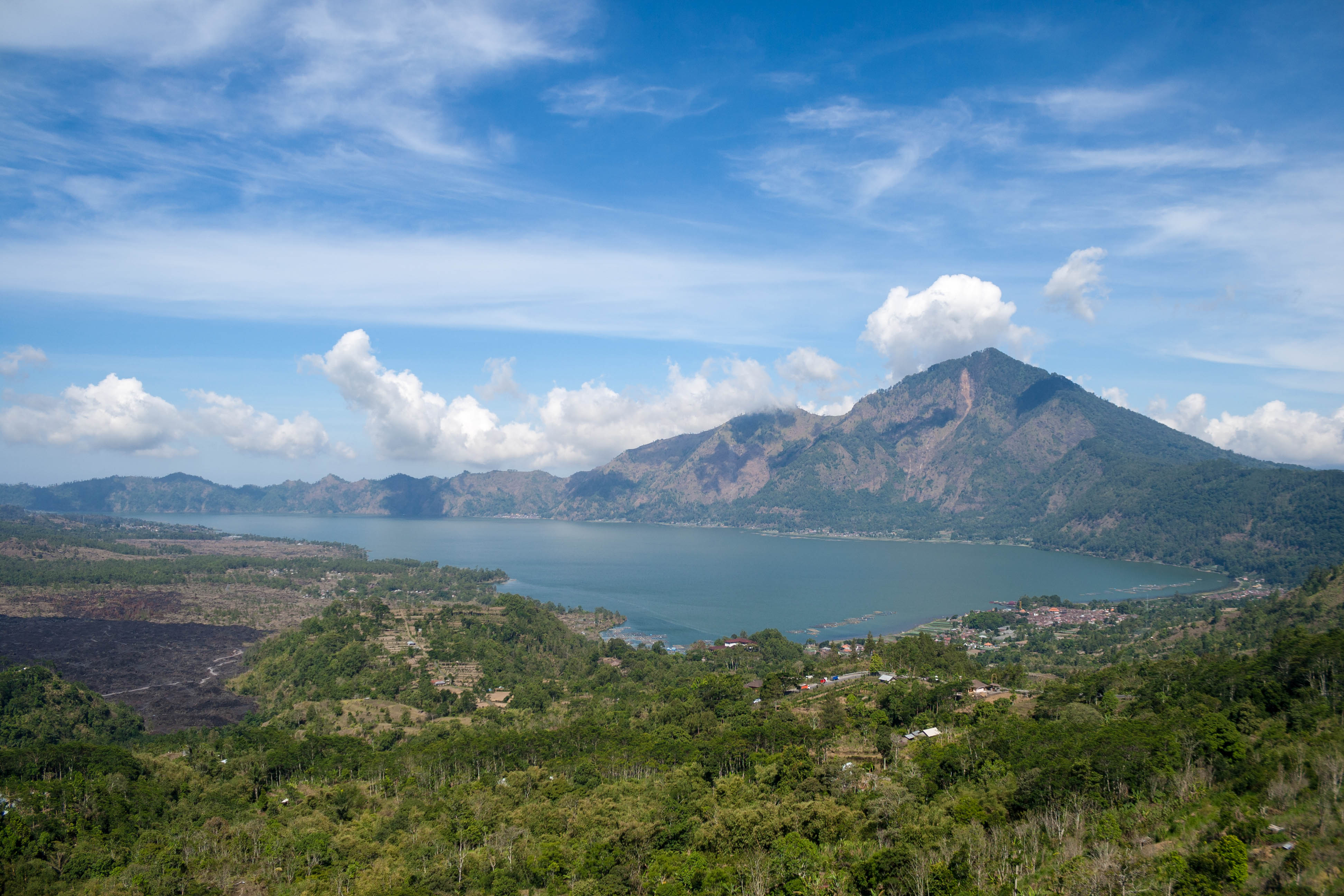
Born from Collapse
Lake Batur sits in the southeastern portion of Mount Batur's caldera, about 30 kilometers northeast of Ubud in Bali's Bangli Regency. The caldera itself is a nested structure -- a larger outer ring roughly 10 by 13 kilometers across, formed when the magma chamber collapsed around 29,300 years ago, with a smaller inner caldera about 7.5 kilometers wide that followed roughly 20,000 years ago. The lake filled the low point of this double depression, collecting rainfall, agricultural runoff, and geothermal inflow into a basin that reaches 88 meters at its deepest. It is the largest lake on the island of Bali, and it sits along the Pacific Ring of Fire, that restless arc of tectonic boundaries where the earth's crust never quite settles.
The Waters That Give and Take
What makes Lake Batur unusual is how many sources feed it. Hot springs in the village of Toya Bungkah, heated by the volcanic plumbing beneath Mount Batur, send mineral-rich water flowing into the lake. These springs have been developed for tourism -- visitors soak in warm pools while looking out across the caldera -- but their geological function is older and simpler: they are vents, pressure releases for the heat building below. Meanwhile, farmers in the caldera cultivate a wide range of produce, pumping water up from the lake for irrigation, then letting it drain back carrying nutrients and sediment. The lake receives everything the caldera gives it. In recent years, aquaculture has added another layer to this exchange. Nile tilapia -- called Ikan Mujair locally -- became the dominant species after fish farming expanded, and by 2011 the lake's biology had been significantly reshaped by these introductions.
A Lake Under Pressure
The fish kill of 2011 was dramatic but not surprising to anyone watching the lake's trajectory. Heavy sedimentation from volcanic ash and agricultural runoff has been steadily shrinking the lake's volume. Water hyacinths, fed by nutrient-rich inflows, have spread across the surface in dense mats that block light and consume oxygen. The combination threatens a feedback loop: sedimentation fills the lake from below while hyacinths smother it from above. Some observers have openly wondered whether the lake could eventually disappear. Plans have been proposed to restrict tourist accommodations around the shoreline, reduce the number of fish farm cages, and dredge accumulated sediment, but progress has been slow against the economic pressures of a region that depends on both agriculture and tourism.
Living in the Caldera
Fifteen villages sit within the caldera walls, with Kedisan, Songan, Trunyan, and Toya Bungkah among the largest. The people here farm, fish, and increasingly cater to tourists who come to hike Mount Batur's summit at dawn or soak in the hot springs. Trunyan, on the lake's eastern shore, is home to the Bali Aga, descendants of the island's original pre-Hindu inhabitants, who practice a distinctive form of open-air burial. The caldera is a self-contained world in many ways -- walled off by ridgelines, fed by its own water cycle, shaped by the volcano at its center. In 2012, UNESCO recognized this landscape by adding Mount Batur's caldera to the Global Geoparks Network, an acknowledgment that the geology here is not just scenery but a living system that has shaped human settlement for millennia.
From the Air
Located at 8.26S, 115.41E in central-eastern Bali. The lake is a prominent dark blue feature cradled within Mount Batur's caldera, easily visible from cruising altitude. The caldera rim (Kintamani viewpoint) sits on the southwest ridge. Nearest major airport is Ngurah Rai International (WADD) approximately 45 nm to the south. Expect tropical convective weather in the afternoons. The lake, the volcanic cone, and the caldera walls form one of Bali's most recognizable aerial landmarks.