Lake Chapala
No water has flowed out of Lake Chapala in over thirty years. That fact, quiet and enormous, defines the story of Mexico's largest freshwater lake. Fed by the Rio Lerma and three smaller rivers, Chapala once drained northwest through the Rio Grande de Santiago toward the Pacific Ocean. But upstream diversion, agricultural demand, and the growing thirst of Guadalajara have reduced the inflow so severely that the lake simply absorbs what it receives and keeps it. In July 2022, the water stood at 63.63 percent of capacity. For a body of water that carbon-14 dating places at 38,000 years old, born in the late Pleistocene on one of the youngest geological areas of the American continent, the modern decline has been breathtakingly fast.
Shallow Water, Deep Time
Lake Chapala is an enormous lake, but not a deep one. Its mean depth is just seven meters, with a maximum of 10.5 meters. It sits in a basin surrounded by sierras with names that catalog the landscape: Cerro Viejo, Cerro San Miguel, Cerro del Tigre. Three small islands break the surface. Isla de los Alacranes is visible from the town of Chapala. Isla Mezcala, the largest, holds the ruins of an old Spanish fort and a former Mexican prison. A third islet, La Isla Menor, huddles next to Mezcala like an afterthought. The lake inherited its status as Mexico's largest freshwater body almost by default: Lake Texcoco, which had been larger, was drained by the Spanish in the early seventeenth century to build what became Mexico City. Chapala has held the title since, though holding it grows harder each decade.
Threatened Lake of the Year
Guadalajara has drawn water from Lake Chapala since the 1950s, and the consequences have been mounting ever since. Water levels began a steep decline in 1979, and though they partially recovered by 2007 and 2008, they have never returned to their pre-decline levels. The Global Nature Fund named Chapala its 'Threatened Lake of the Year' in 2004, drawing international attention to the crisis. Agricultural runoff, domestic sewage, and industrial discharge all contaminate the water. Treatment plants along the Lerma River improved conditions somewhat, but a 2017 study assessed the lake's water quality as a risk to public health. The decline has also exposed political disputes that had been submerged, literally and figuratively, for years. Chapala's fate is tangled with every upstream decision made along the Lerma basin, a watershed that supports agriculture and industry across several Mexican states.
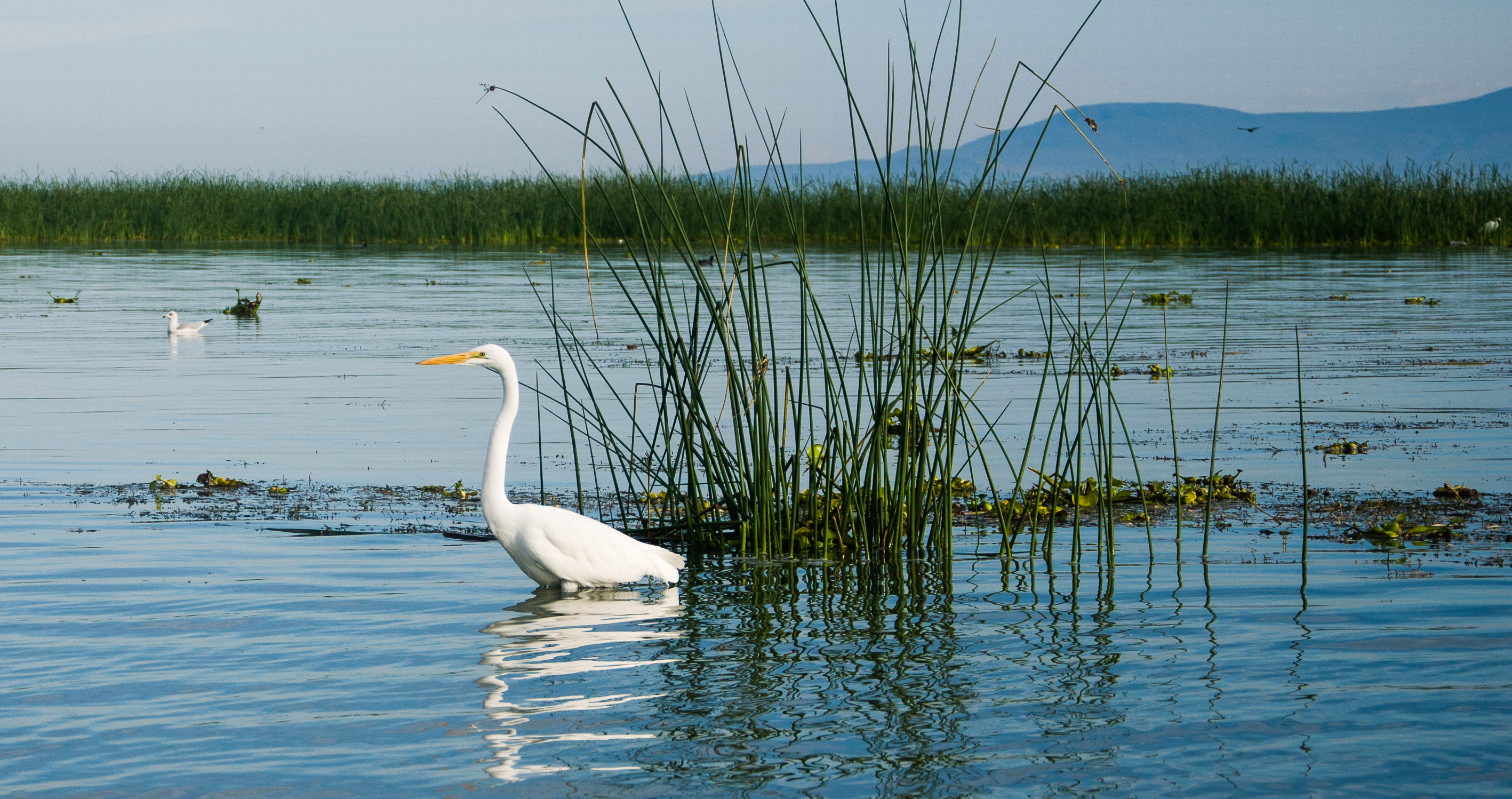
Pelicans, Lampreys, and 173 Species of Bird
Despite its ecological pressures, Lake Chapala remains a critical waypoint for migratory birds, including the American white pelican. The local Audubon chapter, the Audubonistas de Laguna de Chapala, conducts an annual Christmas Bird Count that has documented the lake's avian richness: 117 species in 2006, 125 in 2007, and 173 by January 2011. The lake also harbors species found nowhere else on Earth. The chapalaense subspecies of the rough-footed mud turtle is largely restricted to Chapala, while a semi-aquatic subspecies of the Mexican garter snake lives only in the lake. The waters support a species flock of Chirostoma fish, known locally as charales, along with endemic goodeids, Algansea chubs, two species of Tetrapleurodon lampreys, and the Chapala chub. Several of these endemic species are highly threatened, their survival tied to water levels and quality that humans control.
The Shoreline Villages and 30,000 Expatriates
Dozens of towns and small cities ring the lake: Chapala, Ajijic, Jocotepec, San Juan Cosala, Mezcala de la Asuncion, Tizapan El Alto, and many more. Spanish conquistadors arrived uninvited at these shores in 1530, and Western interest has never fully waned. Tourism took root in the nineteenth century and accelerated through the twentieth, particularly in Ajijic, a town just west of Chapala that became a magnet for artists, writers, and retirees. Today an estimated 30,000 foreign residents live along the lake's shores, making the Chapala Riviera one of the largest expatriate communities in Mexico. The draw is the climate, the cost of living, and the pace of life in lakeside villages where bougainvillea spills over stone walls and the mountains frame every sunset. For the lake itself, the question is whether the communities that depend on it, Mexican and expatriate alike, can reverse the trajectory that turned a Pleistocene giant into a body of water struggling to stay half full.
From the Air
Lake Chapala lies at 20.333N, 103.000W, stretching roughly 80 km east-west between the states of Jalisco and Michoacan. From 5,000-10,000 feet AGL, the lake dominates the landscape south of Guadalajara, its pale blue expanse bordered by mountains on all sides. Three small islands are visible near the northern shore. The town of Chapala sits on the north bank, with Ajijic to its west. Guadalajara International Airport (MMGL) is approximately 45 km to the northwest. The lake surface sits at roughly 1,524 meters (5,000 feet) elevation. Expect haze over the water, especially in warm months.