Lake Clifton
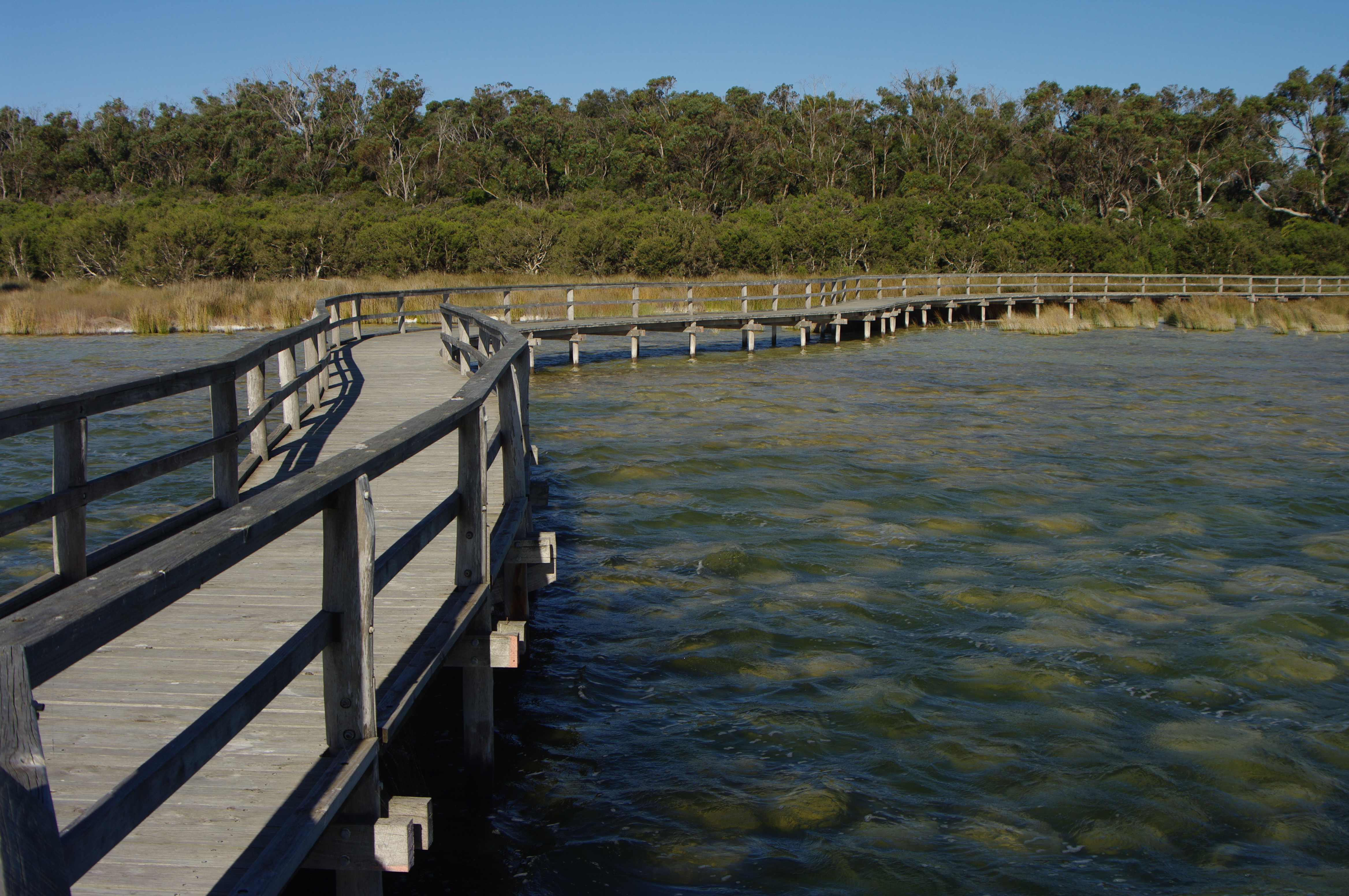
The rocks at the edge of Lake Clifton are not rocks at all. They are thrombolites, lumpy structures built grain by grain over millennia by colonies of microorganisms whose ancestors were among the first living things on Earth. A boardwalk extends over the shallows so visitors can peer down at these fragile formations without crushing them underfoot, and the effect is something like visiting a natural history museum where the exhibits are still alive. Lake Clifton the town sits quietly beside Lake Clifton the body of water, population 759 at last count, a place defined less by what humans have built than by what existed here long before humans arrived.
Three Names Before It Stuck
The lake takes its name from Marshall Waller Clifton, who arrived in Western Australia as Chief Commissioner of the Western Australian Land Company and later served on the Legislative Council. Explorers Dr. Alexander Collie and Lieutenant William Preston first encountered Lakes Preston and Clifton in 1829 while mapping the coastline between Mandurah and Bunbury. European settlement came slowly. John Fouracre built the area's first house in 1852 and established a wayside inn two years later along what would become the Old Coast Road. The townsite itself did not materialize until 1920, when the W.A. Portland Cement Company began mining a lime deposit and needed housing for its workers. Officials first gazetted the town as Leschenault, then changed it to Garbanup when the original name caused confusion with Bunbury. Government railways objected that Garbanup sounded too much like Dardanup, so in 1923 it became Lake Clifton. The cement mine closed that same year, the railway was dismantled and shipped to Lake Grace, and the brief boom ended almost as quickly as it began.
Living Fossils in the Shallows
Along the western shore of the lake, thrombolites rise from the shallow water like weathered stepping stones. Similar to the more famous stromatolites found elsewhere in Western Australia, these structures are built by cyanobacteria and other microorganisms that trap and bind sediment particles, slowly accreting into solid forms. Scientists believe their presence at Lake Clifton is linked to upwellings of fresh groundwater rich in calcium carbonate, which provides the chemical conditions the organisms need to calcify their structures. The thrombolite reef here stretches approximately 15 kilometres along the northeastern shoreline, making it the largest such lake-bound thrombolite reef in the Southern Hemisphere. What makes these formations remarkable is not just their size but their lineage. Microbial structures like these dominated Earth's ecosystems for billions of years before complex life evolved. Walking the observation boardwalk at Lake Clifton is as close as most people will come to witnessing the biological processes that shaped the planet's earliest history.
Yalgorup's Fragile Corridor
The Yalgorup National Park, established in the 1970s, protects the chain of coastal lakes, swamps, and tuart woodland that runs through this stretch of the Peel region. Tuart trees, a species of eucalyptus found only on the Swan Coastal Plain, form woodlands here that once covered vast stretches of the coast but have been reduced by clearing and development. The park also serves as a critical corridor for waterbird migration, connecting wetland habitats along the Western Australian coast. Lake Clifton itself is part of a broader hydrological system fed by seasonal rainfall and groundwater flows, and any disruption to that system threatens the thrombolites that have made the area scientifically significant. The town sits at the northern end of the park, a small community whose identity is increasingly tied to the ancient biology at its doorstep rather than the mining and timber industries that once drove settlement in the region.
Passing Through
Lake Clifton straddles the Old Coast Road, the original route between Mandurah and Bunbury that now forms part of Highway 1. A couple of roadhouses serve passing trucks and motorists, and rural residential estates have sprung up at nearby Tuart Grove, but the town remains fundamentally a place people drive through rather than to. Transwa buses on the Perth-Bunbury route stop here, and the Forrest Highway terminates nearby, connecting the Old Coast Road to the faster inland route north. The community hall hosts local activities, and basic accommodation exists for visitors who come specifically for the thrombolites or the national park. It is a town whose greatest asset lies not in its commerce or infrastructure but in the shallow waters of the lake beside it, where organisms too small to see with the naked eye have been quietly building something extraordinary for longer than anyone can properly comprehend.
From the Air
Located at 32.81S, 115.69E on the eastern shore of Lake Clifton in the Peel region of Western Australia. The lake and adjacent Yalgorup National Park are clearly visible from the air as a chain of coastal lagoons running parallel to the coast between Mandurah and Bunbury. The thrombolite reef is along the western shore but not individually distinguishable from altitude. Nearest airports: Mandurah (no ICAO, private strips) and Bunbury Airport (YBUN) approximately 50 km south. Best viewed at 3,000-5,000 ft to see the chain of lakes and the narrow coastal strip between the Indian Ocean and the Darling Scarp.