Lake Maracaibo
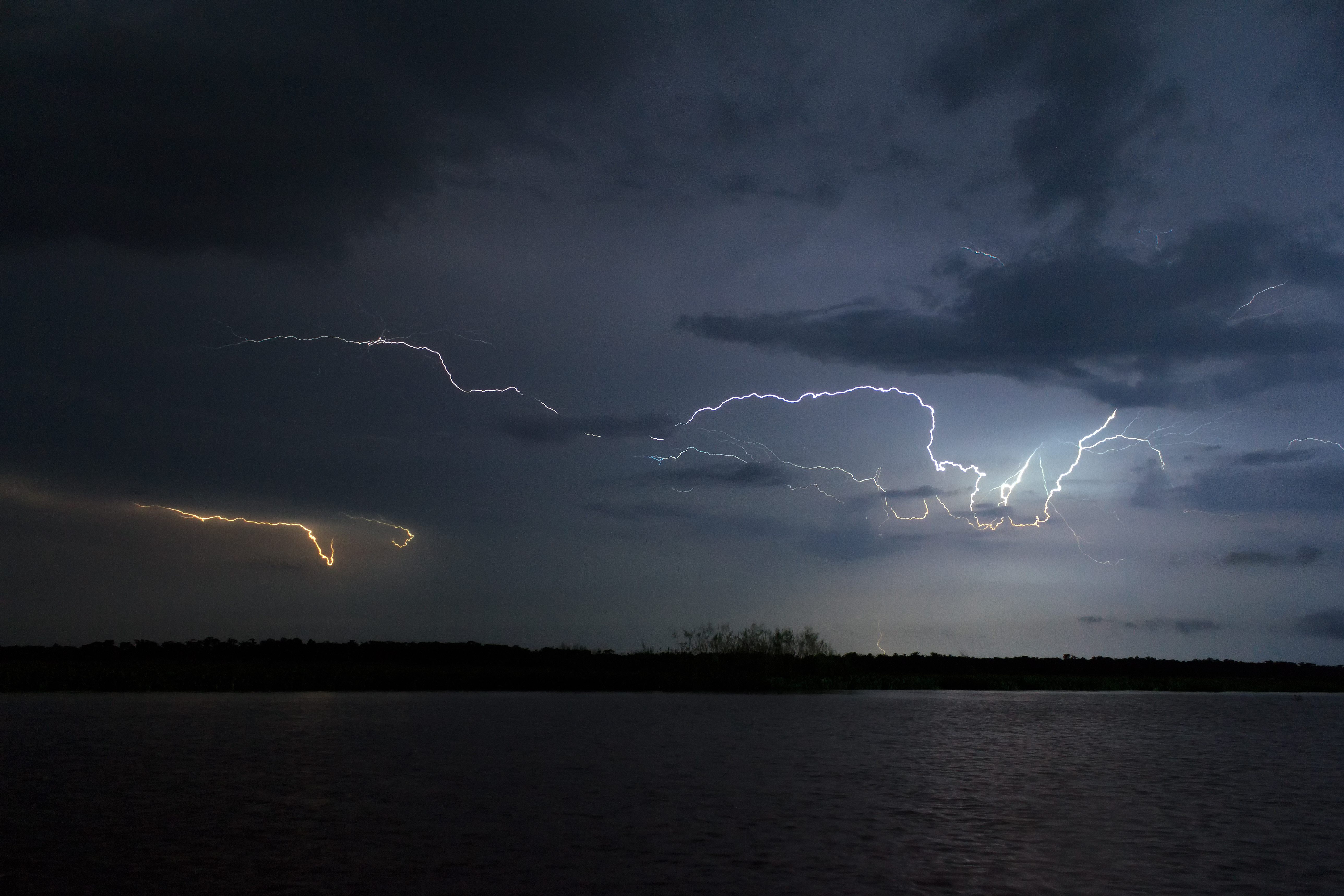
Somewhere over Lake Maracaibo, on an average evening, lightning is striking the water at up to 280 flashes per hour. This is not a storm passing through. It is the Catatumbo lightning -- a phenomenon so persistent it occurs roughly 297 nights per year where the Catatumbo River empties into the lake's southern basin, so reliable that Spanish sailors once used it as a navigation beacon. The lake itself is almost preposterously old, formed 36 million years ago when faults collapsed during the uplift of the Andes. At 13,512 square kilometers, it is the largest lake in South America, larger than Lake Titicaca, though hydrologists debate whether it should properly be called a lake at all. Its northern end connects to the Gulf of Venezuela through a narrow strait, making it technically an estuary -- a body of brackish water that is neither fully fresh nor fully salt, neither entirely lake nor entirely sea.
The Name on the Map
The indigenous peoples who lived along its shores -- the Wayuu, the Caquetios, the Quiriquires -- called the lake Coquivacoa. When Italian navigator Amerigo Vespucci and Spanish explorer Alonso de Ojeda sailed into these waters on August 24, 1499, the stilt houses of the Anu people reminded Vespucci of Venice. He named the region Veneziola -- "Little Venice" -- which became Venezuela in Spanish. The name stuck to the entire country. Spain tried twice to establish settlements around the lake, in 1529 and 1569, before the city of Maracaibo was finally founded in 1574. The lake has witnessed some of the most dramatic chapters in Caribbean history: the privateer Henry Morgan raided its towns and destroyed a Spanish war fleet here in 1669, and the decisive naval battle of Venezuelan independence was fought on its waters on July 24, 1823.
Shaped Like a Vase, Built on Fire
The lake occupies the Maracaibo Basin, a geological depression formed in the late Eocene when the rising Andes caused the underlying faults to collapse. The result is a vase-shaped body of water 210 kilometers long, 121 kilometers wide, and up to 35 meters deep, with roughly 1,000 kilometers of shoreline. Some fifty rivers drain into it, the largest being the Catatumbo, the Chama, and the Escalante. Over millions of years, lighter freshwater floating atop heavier saltwater deposited nutrients that accumulated into a sediment layer more than 5 kilometers thick. Beneath that sediment lies one of the richest petroleum reserves on Earth. The first oil well was drilled in 1917, and large-scale extraction began in 1922. Today the lake floor is crossed by more than 15,000 miles of oil and gas pipelines, most of them over half a century old, many of them leaking.
An Ecosystem Under Siege
Lake Maracaibo's highly oxygenated waters once supported extraordinary biological diversity: endemic species of catfish, tetras, and wolf anchovies found nowhere else on Earth. Blue crabs, clams, and shrimp sustained fishing communities along the shore. But the same oil wealth that made the Maracaibo Basin Venezuela's most productive region has poisoned its waters. The lake has been drilled approximately 14,000 times. Aging underwater pipes leak crude oil into the water column. Agricultural sewage, domestic wastewater, and industrial effluent flow in from the surrounding settlements, where a quarter of Venezuela's population lives. In the spring of 2004, heavy rains flushed nutrients from the lake bottom to the surface, triggering a duckweed bloom that covered 18 percent of the lake and persisted for eight months. The government spent roughly two million dollars per month on cleanup. Coal mining has added a newer layer of contamination, and the random drainage channels called canadas carry garbage from surrounding communities directly into the water.
Bridging the Divide
For centuries, the lake was a barrier as much as a resource, splitting the region between its eastern and western shores. That changed in 1962 with the completion of the General Rafael Urdaneta Bridge, an 8,678-meter span connecting Maracaibo to Santa Rita across the southern part of the strait. At its inauguration it held the record as the longest cable-stayed concrete bridge in the world. The bridge is tall enough to allow vessels up to 45 meters in height to pass beneath it -- a necessity born of the 1950s, when the lake's entrance was dredged from 4 meters to 11 meters deep and a 3-kilometer stone breakwater was built to accommodate ocean-going oil tankers. The lake's islands add further texture to its geography: Toas has tectonic origins, while Zapara and Pescadores are sedimentary. Artificial islands serve the oil industry, including one at Cabimas built specifically for filling tankers.
From the Air
Located at 9.82°N, 71.56°W in northwestern Venezuela. Lake Maracaibo is unmistakable from altitude -- a vast oval of water 210 km long and 121 km wide, connected to the Gulf of Venezuela by a narrow strait in the north. The General Rafael Urdaneta Bridge is clearly visible crossing the strait. The city of Maracaibo sits on the western shore. Oil derricks and pipeline infrastructure are visible across the lake surface. At night, the Catatumbo lightning is visible from great distances near the southern shore where the Catatumbo River enters. Nearest major airport is La Chinita International (SVMC). Best viewed at 10,000-20,000 ft to take in the full extent of the lake and its surrounding Andean foothills.